Part 2
Part 3
Part 4
1. Introduction
The largest single Nazi killing operation against European Jewry, known as Aktion Reinhard(t), centered around three camps on Polish soil that were exclusively built for and dedicated to the systematic killing of human beings. According to the most recent data available, these three camps accounted for about 1,394,000 deaths [1]. All known evidence indicates that much of the remains of these camps' victims still lie under the ground once occupied by these camps, especially in what is left of the huge pits that were used to bury the corpses of those murdered before it was decided to cremate them.
This article starts with a presentation of what is known about the mass graves at these four camps, mainly from forensic and archaeological investigations, followed by a discussion of the main claims and arguments adduced by Holocaust deniers (so-called "Revisionists") Carlo Mattogno, Jürgen Graf and Thomas Kues, in a trilogy authored by the mentioned "Revisionist" trio or one or more of its members,[2] whereby the physical evidence of said mass graves is not compatible with or need not correspond to mass murder on the scale that historiography has established.
2. Number, Dimensions and Contents of the Mass Graves
2.1 Bełżec
2.2 Sobibór
2.3 Treblinka
2.1 Bełżec
Some of the mass graves of Bełżec extermination camp were excavated in 1945 by Polish criminal justice authorities. In his book about Bełżec, "Revisionist" coryphée Carlo Mattogno provided partial translations from the related investigation reports, which speak for themselves[3]:
On October 12, 1945, the Regional Investigative Judge of the district court of Zamosc, Czeslaw Godzieszewski, presented an "Account of the diggings in the cemetery of the Bełżec extermination camp," in which he set down the findings from the inspection of the Bełżec camp he had made that day, aided by 12 workers. In this context, he wrote:
"The opening labeled No. 1 was taken down to a depth of 8 m and a width of 10 m and attained the bottom level of the graves. During the operation, at a depth of about 2 m, we struck the first layer of ash stemming from incinerated human bodies, mixed with sand. This layer was about 1 m thick. The next layer of ash was discovered at a depth of 4 – 6 meters. In the ash removed, some charred remains of human bodies were found, such as hands and arms, women’s hair, as well as human bones not totally burnt. We also recovered pieces of burnt wood. In trench No. 1, the layer of human ash stopped at a depth of 6 meters. The opening labeled No. 2 was taken down to a depth of 6 meters. In this trench, the layer of human ash began at a depth of 1.5 m and continued down to a depth of some 5 m, with occasional breaks. Here, too, the ash contained human hair, part of a human body, pieces of clothing, and remnants of incompletely burnt bones. Openings labeled Nos. 3 and 4 were freed to a depth of 3 meters. In hole No. 4, at a depth of 80 cm, we found a human skull with remnants of skin and hair, as well as two shinbones and a rib. Furthermore, at a level of between one and three meters, these holes yielded human ash mixed with sand and fragments of incompletely burnt human bones. Openings labeled Nos. 5, 6, 7, 8, and 9 were dug to a depth of 2 m, but showed only human ash mixed with sand and human bones, such as jawbones and shinbones. Throughout all the excavations it was observed that the camp cemetery had already been disturbed by wildcat diggings; this is borne out by the fact that the layers of human ash are not uniform but mixed with sand. The recovered human bones; the bodily remains, which where in a state of complete decomposition; and the ash were collected in a common location to await the arrival of the district surgeon. Work was stopped at 17:30 hours."
The next day, October 13, 1945, the findings were inspected by the coroner. The subsequent report describes primarily the results of the examination performed by the judge and the coroner:
"During the inspection of the area of the extermination camp, particularly during the excavations at the place of the cemetery on October 12, 1945, a large number of human bones were found, such as skulls, parts of skulls, vertebrae, ribs, collarbones, shoulder blades, arm bones, lower legs, wrists, fingers, pelvic bones, thigh bones, lower legs, and foot bones. Some of the bones mentioned are either partly burnt or had not been burnt at all. Except for a few skulls showing rotting scalp and hair, the majority of the bones are free from soft tissue. Among the remains of human bodies recovered on October 12, 1945, we identified two forearms and a lumbar portion of the backbone with some soft tissue and traces of carbonization. The lumbar section belongs to an adult, whereas the forearms come from a child a few years old. From the size of the various bones one can conclude that they belong to persons of different age groups, from two-year-olds up to very old people, as borne out by toothless jaws and numerous dentures. Among the jawbones found there was one partially burnt specimen containing milk teeth as well as incipient permanent teeth, which indicates that it belongs to a person 7 to 8 years of age. No traces of bullet holes or other mechanical wounds were found on the skulls. The long bones show no traces either of gunshot wounds or fractures. Because of the advanced state of decomposition it was very difficult to say to what organs the recovered shapeless portions of soft tissue from human bodies might belong. In a hole dug by the local population in a search for gold and valuables, two lower legs belonging to a two-year-old child were discovered. These members are partly decomposed, partly mummified. The area of the cemetery, in particular the wildcat holes, is covered with layers of human ash of varying breadth, which stem from the incineration of human corpses and wood; they are intermingled with sand in varying proportions. The color of the ash varies between light-ash and dark gray; the ash has a heavy consistency and smells of decomposing human bodies. In the ash, charred human bones as well as pieces of charcoal are clearly visible. In the lower strata of the ash the smell of decomposition is more pronounced than in the layers nearer the surface. The hair discovered belongs mainly to women, as shown by their length and by the type of arrangement (braids and buns fixed with hairpins). In addition to natural hair, we encountered ladies’ wigs as well. With this, the inspection was terminated."
The coroner’s report about the inspection of the corpses is followed by an expert opinion not transcribed and translated by Mattogno,[4] of which an English translation is provided hereafter.
Expert Opinion
On grounds of the postmortem examination made I find that the aforementioned bones and soft tissue parts as well as the ash are predominantly of human origin. A very small part comes from wood. Judging by the huge amount of ash and bones I assert that the same must be from a very large quantity of human bodies. The small soft tissue parts of human bodies that are in the ash and not completely carbonized issue a smell that is caused by the decomposition process of the remains of human soft tissue parts. This smell is also caused by the fact that the soil is soaked by the masses of decomposing human corpses that were burned after having been extracted from the soil. Considering the sandy soil in which the human corpses were burned and the state of decomposition of the body parts found, one has to assume that these corpses were presumably buried about 3 years ago. The human body parts not carbonized and the huge amount of hair proves that some corpses were buried after the time when the corpse burning in the extermination camp was stopped, eventually they may also be corpses that were not extracted from the mass grave during cremation. Due to the fact that the skull bones show no traces of shots, it must be assumed that these people did not die from shooting.
Signature: Dr. Mieczyslaw Pietraszkiewicz
Further complementing the reports partially quoted by Mattogno there is the report about an official inspection of the Bełżec site on 10 October 1945, obviously by the same examining judge, the German translation from Polish of which is quoted by German public prosecutor Adalbert Rückerl[5]. The following translation of a part of that report illustrates the extent of the mess of human ashes and other partial remains, brought to the surface by robbery diggers, and especially the size of the area covered by that mess:
Along the camp’s northern border, from about the middle until the point where it touches the eastern border, the camp area is churned up and plowed through in a width of about 100 meters. Also a strip along the whole eastern border is dug up and churned up in a width reaching up to the middle of the whole camp area. According to information from the assisting public servants of the citizens’ militia from the militia post in Bełżec, the described churning-up of the camp area comes from the neighboring population, which was searching for gold and jewels left behind by the murdered Jews. In the churned-up area there lie huge amounts of scattered human bones, skulls, vertebrae, ribs, shinbones, jawbones, tooth implants made of rubber, hair (mainly female and often braided), furthermore pieces of decomposed human flesh like hands and lower limbs of little children. Furthermore there lie on the whole area described above huge amounts of ashes from the burned victims as well as remains of the burned human bones. From the deeply dug-up holes there comes the smell of decomposing human bodies. All this proves that the camp area along the northern and eastern border is a continuous common grave of the people murdered in the camp.
A photo showing a pit made by robbery diggers can be found in the archives of the Ghetto Fighters House (Image 2.1.1)[6]. Another photo from the same source[7] possibly shows some of the human remains examined by the Polish coroner whose report is quoted by Mattogno (Image 2.1.2). The images can be enlarged by clicking on them.
Image 2.1.1

Image 2.1.2

A detailed archaeological investigation, conducted in 1997-1999 by archaeologist Prof. Andrzej Kola of Nicolaus Copernicus University in Toruń, Poland, led to the discovery, approximate measurement and establishing of the contents of 33 mass graves in the Bełżec area. Prof. Kola’s book about this archaeological investigation [8] contains exemplificative core sample drawings from some of these graves, plans and sections of each grave and a description of each grave and its contents (cremation remains as well as whole corpses in some of the graves), as established by core drilling. Digital copies of the core sample drawings, plans and sections of the mass graves and descriptions of the same are available online[9]. Prof. Kola’s finds about the mass graves at Bełżec have been the subject of a lengthy discussion between Mattogno and me[10]. The most important claims and arguments presented by Mattogno in this discussion, as well as their refutation, will be addressed in the present chapter.
Descriptions of the Bełżec mass graves can also be found in a report prepared by Michael Tregenza, a British researcher who accompanied the Bełżec excavations[11], and in a book by another researcher, Robin O’Neill[12]. Tregenza’s descriptions differ from Kola’s as concerns the graves’ measurements and interpretation of their contents, and their graphic detail contrasts with the sober, aseptic descriptions of the mass graves in Prof. Kola’s book.
The presence of corpses in wax fat transformation[13] besides cremation remains is mentioned in Prof. Kola’s description of the graves numbered 1, 3, 4, 10, 13, 20, 25, 27, 28 and 32. Core drilling by Prof. Kola’s team came upon corpse layers up to 2 meters thick[14] in the graves’ lower parts. Why these corpses were left in the graves and not cremated by the SS is not known. Tregenza surmised that "perhaps after five months of supervising day and night the gruesome work of exhuming and cremating the hundreds of thousands of rotting remains the SS had simply had enough, and against orders, abandoned the task"[15]. A likelier explanation is that the SS simply found it too difficult to extract these corpses from the bottom of the graves, as is mentioned regarding Treblinka extermination camp by survivor eyewitness Oscar Strawczyinski, who wrote that the graves "could never be emptied entirely, because blood mixed with water accumulated at the bottom"[16].
The measurements of the mass graves reported by Prof. Kola and his estimates of the graves’ volumes are shown in the following table (which, like all other tables in this blog, can be enlarged by clicking on it). Where I made assumptions because the graves do not have a rectangular shape or no measurement data were provided, this is pointed out in the notes:
Table 2.1.1 Measurements of the Bełżec Mass Graves

Notes:
(1) In grave # 4 drilling was given up at at the depth of 2.30 m, because of a layer of bodies in wax-fat transformation. The volume estimate refers only to the part filled with cremation remains, while the total volume of the grave was not estimated.
(2) The pit was in shape close to a high trapezoid with the base sizes 13.00 and 14.00 m and the height of about 27 m. Length in table is the medium of base sizes.
(3) The grave was very deep (the drills in particular places were stopped at the depth of 4.25 to 5.20 m, because of bodies in wax-fat transformation and underground waters presence). Depth in the table is the maximum depth.
(4) The grave has the shape of an irregular trapezoid, with edges 6.00, 16.00, 11.00, 5.00 and 18.00 m. Area was calculated according to the trapezoid formula (A = ((a+b)÷2) x h), assuming that a = 6 m, b = 5 m and h = 18 m.
(5) In bottom views the grave has a shape of trapezoid with the base of 12.50 and 11.00 m and the height of 17.00 m, with the depth reaching up to 4.80 m.
(6) A vast grave basin of irregular shape. Length came to 37 m, approximate width about 10 m.
(7) In the bottom view the grave has a shape close to a flattened triangle with the base of about 9.00 m and the height of 15.00 m. Height was halved for calculation.
(8) Length and width of this grave are not given by Prof. Kola, figures in table are this writer's guess based on plan and section.
(9) The grave is lengthened and has the shape of an irregular rectangle with the size of about 25.00 x 9.00 m and the maximum depth of about 4.50 m.
(10) Only graves in which Volume estimated < Volume calculated
Prof. Kola’s volume estimates are not identical with the volumes established by multiplying the values for a grave’s length, width and depth in the table, but tend to be smaller, sometimes considerably so, for example in graves nos. 1 (1,500 vs. 2,304 m³), 8 (850 vs. 1,120 m³) and 20 (1,150 vs. 1,430 m³). The total volume of all graves according to Prof. Kola’s estimates is 21,310 cubic meters, of which 15,840 cubic meters (line "Subtotals") correspond to graves in which the estimated volume is smaller than the calculated volume in Table 2.1.1. The sum of estimated volumes in these graves (15,840 m³) is about 86.6 % of the sum of calculated volumes in the line "Subtotals" (18,290 m³). This difference is probably due not or not only to my assumptions or the irregular shape of some graves (graves nos. 1, 8 and 20 are regularly shaped rectangles), but also and especially to the sloping of the graves’ walls in order to achieve greater stability in the sandy soil of Bełżec, which led to graves being narrower at the bottom than at the top. The deeper a grave, the higher the volume reduction due to sloping is likely to be. For a grave 50 meters long, 25 meters wide and 10 meters deep (50 x 25 x 10 = 12,500 cubic meters), Alex Bay calculated an actual volume (considering the walls’ sloping) of 8,502 cubic meters, i.e. 68 % of the volume calculated by multiplying length, width and depth[17]. The graves at Bełżec were not that deep and the volume loss due to sloping was thus probably less. Nevertheless, it seems recommendable to apply at least the percentage mentioned above (actual volume = 86.6 % of volume calculated by multiplying measurements) when estimating the volume of a mass grave based on its length, width and depth.
Matching Prof. Kola's maps with his analysis of wartime air photographs, Alex Bay argues that Prof. Kola did not discover all of the Nazi mass graves at Bełżec[18]. Bay’s demonstration is persuasive enough[19] to at least consider the possibility that the mass grave volume available at Bełżec was somewhat higher than what becomes apparent from Prof. Kola’s estimates. However, as Bay’s study provides no data that would allow for calculating the size and volume of the additional graves he points out, it will be assumed in the following that the grave volume available for burial at Bełżec was as estimated by Prof. Kola.
The 21,310 cubic meters of mass grave volume that Prof. Kola’s estimates add up to include graves that must be assumed to have been used only to dump cremation remains but never to bury whole bodies, because of their small volume (< 150 m³) or because they are expressly referred to as crematory graves by Prof. Kola (grave # 2). I assumed that graves nos. 2, 11, 21, 28, 30, 31 and 33, with a total estimated volume of 640 m³, were mere crematory graves. The grave volume available for burying corpses is thus considered to have been 21,310 – 640 = 20,670 cubic meters.
2.2 Sobibór
A description of the Sobibór site during postwar examinations by investigating judge Zdzisław Łukaszkiewicz is quoted Mattogno, Graf & Kues’ book about Sobibór[20]. Łukaszkiewicz mentioned that "in the central part of the area, presumably at the sites used for burial of the ashes, there is a growth of young firs covering some 1,200 square meters" and that diggings "showed the presence of ashes and of bone fragments mixed with ashes below a layer of sand half a meter thick", furthermore that over the whole area of the camp "human bones can be found here and there". He referred to an opinion prepared by the institute of forensic medicine of the Jagellonian University whereby "the bones sent there for analysis were human bones", and an opinion of the institute of forensic medicine at Cracow indicating that "the sand removed from the diggings is mixed with bone ashes and fat".
Photos presumably related to the site inspection conducted by Polish investigators or to robbery digging in the former extermination camp’s area can be found in the Archives of the Ghetto Fighters’ House, including those shown in Images 2.2.1 and 2.2.2 below.[21]
Image 2.2.1

Image 2.2.2

Bone fragments still littered the area around the Sobibór mass graves and memorial when I visited it between 14 and 16 October 2008[22].
Like the area of Bełżec extermination camp, the Sobibór area was also subject to an archaeological investigation headed by the same Prof. Andrzej Kola who had conducted the archaeological investigation at Bełżec. The location, size and contents of the mass graves surrounding the Sobibor memorial were described as follows in Prof. Kola’s report about his archaeological research[23]:
Grave no 1 is located in the north - eastern part of hectare 17, just west from the memorial to victims. The site was excavated by 27 drills. Horizontally, it measures 20 x 20 m and is up to 4.30 m deep. It was a body burning grave.
Grave no 2 is located in the western part of the hectare 17, south from the memorial. It was excavated by 28 drills. Horizontally its shape is irregular, measuring at least 20 x 25 m – with its longer side in NS position – and with depth up to 4 metres. It was a body burning grave.
Grave no 3 is located in the south- western part of hectare 11 and north - western part of hectare 17. It was excavated by 17 drills. Horizontally, it's irregular, measuring around 20 x 12 m - with its longer side in NS position. The biggest part of the grave is located under north - western part of the memorial. It’s up to 5.80 m deep. In bottom layers, the grave is bony, with human remains in wax- fat transformation. The upper layers are a mixture of burnt body remains with layers of lime stone, sand and charcoal. The northern part of the grave is located near to northern part of the grave no 4. The more precise location of the graves requires additional research.
Grave no 4. It’s a grave with significant size, located in southern part of hectare 11, as well as northern and central parts of hectare 18. It was excavated by 78 drills. Horizontally, in NS position, it measures 70 x 20-25 m with the depth of around 5m. In bottom layers the grave is bony, with human remains in wax-fat transformation. The upper layers are a mixture of burnt body remains with layers of lime stone, sand and charcoal.
[...]
Grave no 5. It’s not a very vast grave, located in the north-western part of hectare 18. It was excavated by 7 drills. Horizontally, it's irregular, measuring at least 10 x 12 m, with its depth up to 4.90 m. In its bottom layers the grave is bony, with human remains in wax-fat transformation. In the upper layers – burnt body remains.
Grave no 6. It’s located in the central part of hectare 18, south from grave no 5. It was excavated by 22 drills. Horizontally, it’s irregular, measuring at least 15 x 25 m, with its depth up to 3.05 m. In its bottom layers the grave is bony, with human remains in wax-fat transformation. The upper layers - burnt body remains.
Grave no 7. Location of body burning activity, measuring at least 10 x 3 m, with its depth up to 0.90 m, in the central part of hectare 18, around 10-12 m south from the southern side of grave 4. The vast majority of burnt body remains were found in 6 drills. Around, vast ground transformation of an uncertain genesis. Only because of the burnt body remains found, the structure was thought of as a grave. In order to state the function of the place more accurately, further archaeological research needs to be conducted.
Prof. Kola’s findings about the location and shape of the mass graves are plotted on two maps on pages 122 and 123 of the cited publication, the larger of which is shown below (Image 2.2.3); I added the numbering of the graves according to the above-quoted description.
Image 2.2.3

The mapping of archaeological finds is corroborated by the coincidence of some of these graves with greener areas clearly visible on a satellite photograph of the Sobibor memorial area, as shown in Image 2.2.4 below[24].
Image 2.2.4

They are also corroborated by air photos published in an article by archaeologists Isaac Gilead, Yoram Haimi and Wojciech Mazurek, who are carrying out further investigations on the Sobibór site[25].
Prof. Kola’s descriptions of the mass graves contain the information required to calculate the available burial volume, applying the percentage established above (ca. 86.6 %) to take account of volume loss due to sloping of the grave walls. Grave # 7, which according to the archaeologist’s description was obviously a cremation site or a pit to dump cremation remains but never a burial grave, was not included in the graves mentioned in Table 2.2.1 below.
Table 2.2.1 Measurements of the Sobibor Mass Graves

According to Prof. Kola’s description, two of the graves in the above table – nos. 1 and 2 – were mere body-burning graves, never used to bury whole corpses. Assuming that the archaeologist’s findings are correct, this means that only graves 3, 4, 5 and 6, with a total volume (corrected for sloping) of 9,525 cubic meters, were used for burial at Sobibór extermination camp.
A look at the annotated satellite image above (Image 2.2.4) shows that graves nos. 3 and 4 were next to each other, and so were graves nos. 5 and 6. This suggests the possibility that each of these pairs was a single grave during camp times, which would explain why former SS-man Bolender spoke of two graves in his deposition on 18 December 1963 in Hagen.[26]
2.3 Treblinka
Unlike the areas of the other two extermination camps of Aktion Reinhard(t), the area of Treblinka extermination camp has not yet been subject to an archaeological investigation. The most thorough investigation of the Treblinka site to this day was carried out in November 1945 by Judge Zdzisław Łukaszkiewicz. The thoroughness of this investigation is acknowledged even by Mattogno & Graf (M&G), who provide what they claim to be a complete translation of the report of 13 November 1945 signed by Examining Judge Łukaszkiewicz and State Attorney Maciejewski.[27] M&G also quote parts of Łukaszkiewicz' protocol dated 29 December 1945, which was presented by the Soviets at the Nuremberg Trial as Document USSR-344[28]. The parts of either report referring to a mass graves area, as rendered by M&G, are transcribed hereafter.
From the report of 13 November 1945:
The largest of the craters produced by explosions (numerous fragments attest to the fact that these explosions were set off by bombs), which is at maximum 6 meters deep and has a diameter of about 25 meters – its walls give recognizable evidence of the presence of a large quantity of ashes as well as human remains – was further excavated in order to discover the depth of the pit in this part of the camp. Numerous human remains were found by these excavations, partially still in a state of decomposition. The soil consists of ashes interspersed with sand, is of a dark gray color and granulous in form. During the excavations, the soil gave off an intense odor of burning and decay. At a depth of 7.5 meters the bottom was reached, which consisted of layers of unmixed sand. At this point the digging was stopped here.
From the report of 29 December 1945:
With the assistance of an expert land surveyor and witnesses, I made an exact inspection of the terrain. According to the measurements, the area of the camp is approximately 13.45 hectares and had the shape of an irregular quadrilateral.[…] In the northwestern section of the area, the surface is covered for about 2 hectares by a mixture of ashes and sand. In this mixture, one finds countless human bones, often still covered with tissue remains, which are in a condition of decomposition. During the inspection, which I made with the assistance of an expert in forensic medicine, it was determined that the ashes are without any doubt of human origin (remains of cremated human bones). The examination of human skulls could discover no trace of« wounding. At a distance of some 100 m, there is now an unpleasant odor of burning and decay.
Mattogno & Graf claimed that Łukaszkiewicz' investigations had failed to produce evidence of mass murder, obviously failing to take into account what
a) the depth of the crater in which Łukaszkiewicz' ordered further excavations "to discover the depth of the pit[s][29] in this part of the camp" (7.5 meters!), and
b) the size of the area he found to be covered by human ashes and larger partial human remains, which was obviously the burial area or one of the burial areas of the Treblinka extermination camp sector (2 hectares = 20,000 square meters),
revealed about the enormous amount of burial space that had existed at that camp.
The aspect of the Treblinka site and the robbery digging there was also conveyed by Karol Ogrodowczyk, member of a delegation from Warsaw that inspected the site[30]:
"The fields are dug up and rummaged through, the pits are about 10 meters deep, bones are lying around and objects of all kinds, shoes, spoons, forks, chandeliers, hair of wigs worn by Jewesses. In the air hangs the stench of decomposing corpses. … The foul smell so numbed me and my colleagues that we vomited and felt an unusual rasping in the throat. (...) Under every tree seekers of gold and gems have dug holes (...) Between the trees cavort local peasants, eager to find treasures. When we ask them 'What are you doing here?' they give no answer."
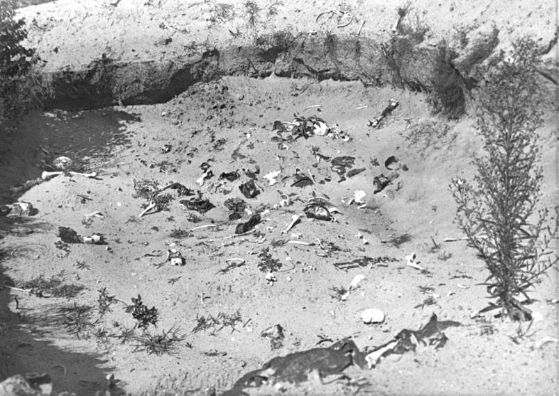
A number of photos illustrating the above-quoted descriptions of the Treblinka site are included in one of my photo collections[31]. Four of these photos – showing, respectively, a moonscape of holes and what seem to be bones (Image 2.3.1), upturned soil/ash saturated with white shards that are obviously bone fragments (Image 2.3.2), a close-up of skulls and bones (Image 2.3.3) and a larger pit in the camp area (Image 2.3.4) – are reproduced below.
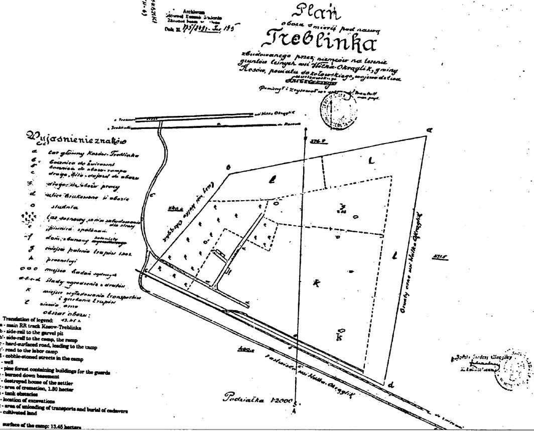
Neither of the aforementioned investigations provided information about the number of mass graves and the shape and size of each of them. However, a contemporary map related to Łukaszkiewicz investigation (Image 2.3.5)[32] shows a 1.8 ha area in the camp’s south-eastern part called the "area of cremation".
Image 2.3.1[33]

Image 2.3.2[34]

Image 2.3.3[35]

Image 2.3.4[36]

Image 2.3.5

This must have been the area covered by ashes and larger human remains that was described by Łukaszkiewicz in his report of 29 December 1945, where its size is rounded upwards to the nearest full hectare and its location is wrongly (maybe due to a misreading of the map) given as being the northwestern part of the camp.
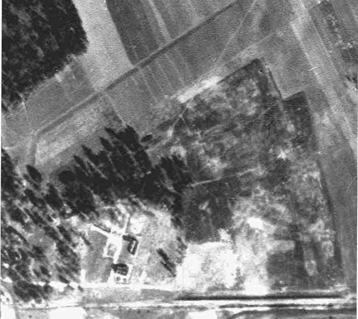
On a copy of air photo of the (by then long dismantled) Treblinka extermination camp taken in September 1944[37], I have highlighted an area with the aspect of what I would expect the "area of cremation" to look like on an air photo, considering Łukaszkiewicz description (Image 2.3.6). The soil in this area is thoroughly churned up – so thoroughly that, according to Alex Bay, it is not longer possible to make out the shapes of individual mass graves.[38]
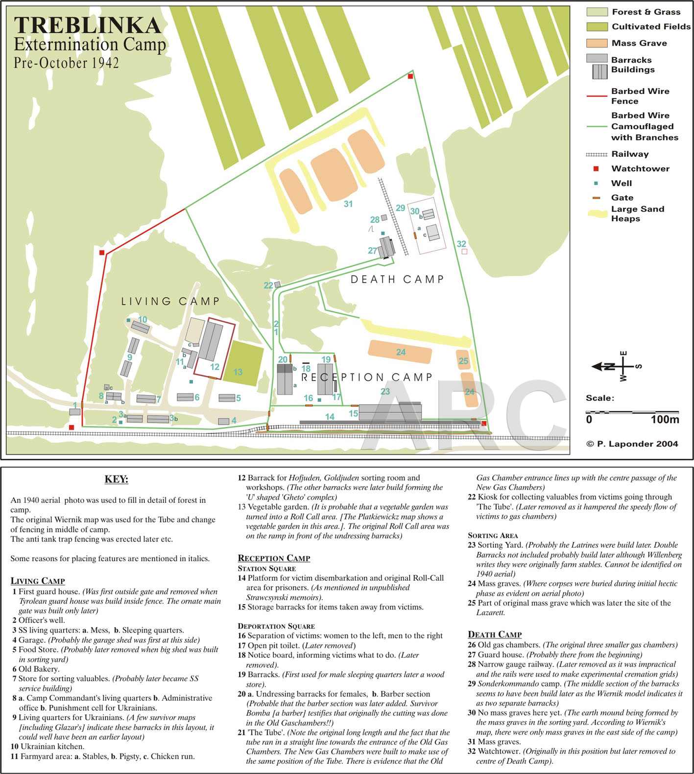
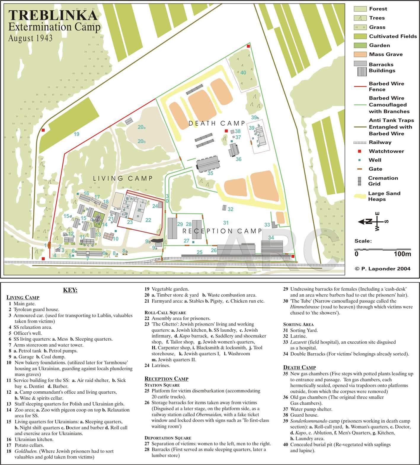
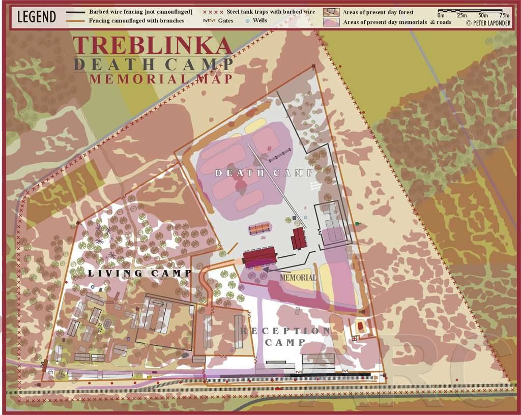
In the camp’s former "reception" area/sorting yard, on the other hand, Peter Laponder, author of a model of Treblinka[39] and three maps of the camp[40] identified several mass graves on the September 1944 photograph (Image 2.3.7).[41]
Image 2.3.6

Image 2.3.7

According to Peter Laponder, arrow "1" in Image 2.3.7 shows the position of the high earth mound between the camp’s sorting yard and the "death camp" extermination sector, arrow "2" shows the position of the "Lazarett" (where sick and infirm people arriving at Treblinka, who would otherwise slow down the march of the other arrivals to the gas chambers, were shot and their bodies burned inside a pit) and arrows "3" shows "In all probability the Pits for Corpses which were used during the first phase of Treblinka".
Unlike at least one of the pits in the "death camp" sector, excavated during Judge Łukaszkiewicz’ investigation in November 1945, the early burial pits identified by Mr. Laponder and shown in his map of Treblinka before October 1942[42] don’t seem to have been excavated by investigators, with the possible exception of the one that later became the body disposal pit of the "Lazarett". Łukaszkiewicz mentioned having ordered digging in a bomb crater 4 to 5 meters deep at the location where according to witness Rajzman the "camp hospital" had stood and a mass grave was supposed to be, and found numerous coins as well as broken pieces of various containers but no human remains. If indeed Łukaszkiewicz’s workers had been digging in the mass grave by the "Lazarett", the reported absence of "human remains" (a term that, as the previously quoted excerpt from his report of 13 November 1945 shows, Łukaszkiewicz used only for human remains larger than ashes) must have been due to the fact that the pit was completely cleared of human remains at some time during the camp's dismantlement and subsequently used merely as a pit for discarding objects that the SS considered useless. An archaeological investigation such as has been conducted at Bełżec and Sobibór could provide further information to help remove this uncertainty.
Notes
[1]Bełżec: 434,508 deportees (rounded to 435,000) mentioned in the report sent by SS-Sturmbannführer Höfle in Lublin on 11 January 1943 to SS-Obersturmbannführer Heim in Krakow (hereinafter called the "Höfle Report"), see Peter Witte and Stephen Tyas, "A New Document on the Deportation and Murder of Jews during 'Einsatz Reinhardt' 1942", Holocaust and Genocide Studies 15:3 (2001) pp. 468-486 (hereinafter "Witte and Tyas"). Sobibór: 170,165 (rounded to 170,000), thereof 101,370 until 31 December 1942 mentioned in the Höfle Report plus 68,795 in 1943, see Jules Schelvis, Sobibor: A History Of A Nazi Death Camp, 2007 by Oxford International Publishers Ltd. in association with the United Stated Holocaust Memorial Museum (hereinafter "Schelvis 2007"), p. 198. Treblinka: 713,555 until 31 December 1942 mentioned in the Höfle Report, plus 8,000 deportees from Theresienstadt in October 1942, mentioned in Yitzhak Arad, Belzec, Sobibor, Treblinka. The Operation Reinhard Death Camps, Indiana University Press, Bloomington and Indianapolis 1987 (hereinafter "Arad, Reinhard"), pp. 141/142, which I assume not to be included in Höfle’s figure. In 1943 there arrived a recorded 53,149 deportees from the General Government and the Bialystok District (including 2,000 Sinti and Roma) and 14,159 deportees from Saloniki, Macedonia and Thessaloniki (Jacek Andrzej Młynarczyk, Treblinka – Ein Todeslager im Rahmen der "Aktion Reinhard", in: Bogdan Musial (editor), Aktion Reinhardt Der Völkermord an den Juden im Generalgouvernement 1941-1944, pp. 257-281, here pp. 280f.) The total number of recorded deportees to Treblinka was thus 788,863 (rounded to 789,000).
[2] Bełżec: Carlo Mattogno, Bełżec. Propaganda, Zeugenaussagen, archäologische Untersuchungen, historische Fakten, Castle Hill Publishers, Hastings 2004. English version: Bełżec in Propaganda, Testimonies, Archeological Research and History, Theses & Dissertation Press, Chicago 2004. Sobibór: Carlo Mattogno, Jürgen Graf, Thomas Kues, Sobibór: Holocaust Propaganda and Reality, 2010 The Barnes Review, Washington D.C. Treblinka: Carlo Mattogno and Jürgen Graf, Treblinka – Vernichtungslager oder Durchgangslager?, Castle Hill Publishers, Hastings 2002. English version: Treblinka – Extermination Camp or Transit Camp, Theses & Dissertation Press, Chicago 2003. The three books are hereinafter referred to as, respectively, "Mattogno, Bełżec", "MGK, Sobibór" and "M&G, Treblinka". Where there is also a version in another language, references are made to the respective English version, unless otherwise stated.
[3] Mattogno, Bełżec, pages 79 f. Mattogno argued that the coroner’s «insistence, in the description, on single bones as if they were unique pieces leaves us wondering about the value one should attribute to the "very large" quantity of corpses conjectured by the coroner» – a conspiracy theory oblivious of the fact that the coroner was obviously interested in what the remains examined revealed about the victims’ age and sex, especially the presence of children among the victims. For the German translations from Polish of the excavation protocol dd. 12 October 1945 and coroner Dr. Mieczyslaw Pietraszkiewicz’s report and opinion of 13 October 1945, which were partially transcribed and translated by Mattogno, see BAL (Bundesarchiv Zweigstelle Ludwigsburg, German Federal Archives Ludwigsburg Branch Office) B162/208 AR-Z 252/59, Bd. VI, fl. 1121 ff. Digital copies of these pages are included in Jules Schelvis’ research files published as PDF by the Dutch archives, hereinafter referred to as "Schelvis files", in this case Schelvis file 8, pp. 127 ff. (pagination refers to the PDF view).
[4] German translation from Polish in BAL B162/208 AR-Z 252/59, Bd. VI, fl. 1124, Schelvis file 8, p. 131.
[5] Rückerl, Adalbert, NS-Vernichtungslager im Spiegel deutscher Strafprozesse,(hereinafter "Rückerl, Vernichtungslager"), 2nd edition 1978 by Deutscher Taschenbuch Verlag GmbH & Co. KG, Munich, pages 143 - 145.
[6] Brief Description: Pits dug on the grounds of the Belzec camp by Poles scavenging for valuables that had belonged to the camp's victims. Catalog No.: 10891
[7] Brief Description: The skulls and bones of Belzec camp victims, brought to a bunker on the grounds of the camp. Catalog No.: 10892
[8] Kola, Andrzej (2000) Bełżec: the Nazi Camp for Jews in Light of Archaeological Sources: Excavations 1997-1999, Warsaw-Washington, The Council for the Protection of Memory of Combat and Martyrdom and the United States Holocaust Memorial Museum (hereinafter "Kola, Bełżec").
[9] See the thread Archaeological investigation of Belzec mass graves on this blog site’s forum. The core sample drawings are on pages 14 to 18 of the book, the plans and sections and descriptions of the mass graves on pages 21 to 40. Page 19 includes a map of the graves and on page 70 there is a map of the core drillings whereby the graves were identified.
[10] See the series Carlo Mattogno on Belzec Archaeological Research.
[11] Tregenza, Michael, Report on the Archeological Investigation at the Site of the Former Nazi Extermination Camp in Belzec Poland, 1997-98, Lublin, 1998 (hereinafter "Tregenza, Report").
[12]O’Neill, Robin (2004), Belzec: Stepping Stone to Genocide Hitler’s answer to the Jewish Question (hereinafter "O’Neill, Belzec"). Descriptions of the mass graves are in Chapter 15.
[13] Wax-fat transformation, as explained on the Australian Museum’s related webpage, is as state in which grave wax, also known as adipocere, "accumulates on those parts of the body that contain fat - the cheeks, breasts, abdomen and buttocks. It is the product of a chemical reaction in which fats react with water and hydrogen in the presence of bacterial enzymes, breaking down into fatty acids and soaps. Adipocere is resistant to bacteria and can protect a corpse, slowing further decomposition".
[14] Kola, Bełżec, page 20.
[15] Tregenza, Report, page 27.
[16] Cymlich, Israel and Strawczynski, Oskar, Escaping Hell in Treblinka. Yad Vashem and the Holocaust Survivors’ Memoirs Project: New York, 2007 (hereinafter "Escaping Hell"), page 169.
[17] Alex Bay, The Reconstruction of Treblinka (hereinafter "Bay, Treblinka"), Appendix D - Ash Disposal and Burial Pits (Continued).
[18] Bay, Alex, The Reconstruction of Bełżec (hereinafter "Bay, Belzec"), 4.6 - Camp II: The Killing and Graves Area.
[19] See the discussion in Belzec Mass Graves and Archaeology - Continuation (2).
[20] MGK, Sobibór, pages 107/108. MGK’s source is Z. Łukaszkiewicz, Glowna Komisja Badania Zbrodni Niemieckich w Polsce, "Obóz zaglady w Sobiborze", in: Biuletyn Glownej Komisji Badania Zbrodni Niemieckich w Polsce, No. III, Posen 1947, p. 49.
[21] Image 2.2.1: Brief Description: Pits in the woods near the Sobibor extermination camp, in which victims were buried. Catalog No.: 11683. Image 2.2.2: Brief Description: The woods of Sobibor, photographed after the war. Catalog No.: 11681
[22] See the thread My Trip to Sobibór on the RODOH discussion forum, which contains numerous photos and film stills showing such bone fragments as well as the aspect of the area around the memorial.
[23] Kola, Andrzej, "I Badania archeologiczne terenu byłego obozu zagłady Żydów w Sobiborze w 2001 r" ("1st Archaeological Research of the Former Jew Extermination Camp at Sobibor in 2001", hereinafter "Kola, Sobibór"), in: Przeszłość i Pamięć. Biuletyn Rady Ochrony Pamięci Walk i Męczeństwa Nr. 4 (21) z 2001 r, pages 115 to 123; descriptions of mass graves on pages 116/117. Translated into English by Katarzyna Piotrowska. The translation is available in the thread 1st Archaeological Research of the Former Jew Extermination Camp at Sobibór in 2001.
[24] The satellite photograph on which I wrote the numbers of the graves is an enlargement of a Google satellite map as it looked at the time of my blog Mass Graves at Sobibor – 10th Update. Graves 2, 3, 4 and 6, and to a lesser extent also grave 1, can be distinguished as areas where vegetation grows more strongly than in their surroundings. John Hunter and Margaret Cox, Forensic Archaeology, 2005 Routledge, New York (hereinafter "Hunter & Cox"), p. 34, write that "The disturbance created by a grave, although relatively insignificant in volumetric terms in the context of a wider landscape, can induce various strong visual effects and can be long-term (…). These can include color change (i.e. from stressed vegetation), enhanced or inhibited flowering, shadows from increased or stunted growth with the presence of a low sun (e.g. winter months or summer mornings or evenings), and spreads of subsurface material in plough soil according to the timing of the agricultural cycle". The wording suggests that this can but need not always happen, which means that, while the visibility of such changes on air or satellite photography signals the presence of graves, the non-visibility thereof does not necessarily signal their absence.
[25] Gilead, Isaac, Yoram Haimi and Wojciech Mazurek, "Excavating Nazi Extermination Centres" (hereinafter "Gilead et al, Extermination Centres") in: Present Pasts, Vol 1 (2009), online.
[26] Quoted in Schelvis 2007, pp.110-1. In his deposition in Hagen on 18.12.1963 (Dortmund Public Prosecutor’s Office Ref. StA.Do Sob 35-116, copy in Schelvis file 46, pp. 213 ff., p. 217) Bolender mentioned that the second grave started being used when it was not yet completely finished because the first grave was completely full. The second grave’s not having been completely finished may be the explanation for grave # 6 being considerably less deep than grave # 5 (3.05 m vs. 4.90 m). Another former SS-man, Hubert Gomerski, mentioned that there had been three huge pits, of which the third was no longer used to bury corpses as the camp’s body disposal method was changed from burial to cremation (depositions of Hubert Gomerki in Butzbach prison on 24 February 1964, BAL B162/208 AR-Z 252/59, Bd. VII, fl. 1254-8, Schelvis file 48, pp. 121 ff., pp. 122-23) and on 30.11.1965 in the main proceedings of the trial against Kurt Bolender et al in Hagen (StA Dortmund IV 1965, fl. 709, 712 Schelvis file 48, pp. 141, 142 and 144). It is possible that graves nos. 1 and 2 identified by Prof. Kola are parts of said third pit, which Gomerski referred to as "die obere Grube", the upper pit, presumably by reference to the map drawn by former SS-man Erich Bauer and used at the Hagen trial. The map is included in the judgment LG Hagen v. 20.12.1966, 11 Ks 1/62, Justiz und NS-Verbrechen XXV, Lfd. Nr 642 and shown in a partial translation of this judgment available online.
[27] M&G, Treblinka, pp. 84-86
[28]Ibid, p.87.
[29] The German text of M&G, Treblinka, p.107 reads: "um die Tiefe der Gruben in diesem Lagerteil zu ermitteln" - "to discover the depth of the pits in this part of the camp". Łukaszkiewicz obviously assumed that the crater had been blown into one of the pits used to bury the corpses in "this part of the camp" – his earlier mention of searching for the gas chamber building shows that he was in the former extermination sector of Treblinka – and that, by digging below the bottom of the crater to the bottom of this pit, he would establish how deep the burial pits in the extermination sector had been.
[30] Piotr Głuchowski and Marcin Kowalski, "Gorączka złota w Treblince" ("Gold Rush in Treblinka"; hereinafter "Głuchowski and Kowalski, Gold Rush"), in: Duży Format Nr. 1/760, 7. January 2008, attachment to Gazeta Wyborcza, pages 2 to 4; translated into German by Dr. phil. Joachim Neander, whose translation I translated into English.
[31] Photographic documentation of Nazi crimes, photos numbered 1.1.79, 1.1.84, 1.1.85, 1.3.1 to 1.3.7, 2.7.1 and 2.7.2.
[32] Survey Map 1945, shown on the webpage Mapping Treblinka.
[33] Brief Description: Heaps of ashes on the grounds of the Treblinka camp. Catalog No.: 11337.
[34] Brief Description: A heap of ashes in the Treblinka camp. Catalog No.: 11341.
[35] Brief Description: Human skeletal remains in the Treblinka camp. Catalog No.: 11338.
[36] Webpage Treblinka - Last Traces HUMAN REMNANTS AND BELONGINGS #2
[37] As note 32, 1944 AERIAL PHOTO
[38] Bay, Treblinka, Reconstruction of the Death Camp.
[39] Presented on the webpage The 2004 Laponder Model.
[40] Treblinka Extermination Camp Pre-October 1942, Treblinka Extermination Camp August 1943 and Treblinka Death Camp Memorial Map.
[41] Peter Laponder, RECONSTRUEING THE RECEPTION CAMP – SORTING YARD AREA - 29 PIT FOR CORPSES, part of the considerations underlying the making of the model, sent to the author as attachment to a private message on 28 November 2006.
[42] Treblinka Extermination Camp Pre-October 1942
Come mai (domanda retorica) gli ebrei sono così bugiardi?
ReplyDeleteWrite English or piss off, asshole.
ReplyDelete