What is known about these mass graves, which are probably the largest ever made?
Many blogs on this blog site (labeled "graves") have mentioned these graves and addressed related issues, especially "Revisionist" claims that the graves do not contain amounts of human remains compatible with the scale of mass murder that becomes apparent from other evidence or were not even large enough to take in the number of corpses that according to such other evidence were produced at each camp[2].
The purpose of the present blog is to put together in one place the information currently known to this writer about the size and contents of the mass graves at the four Nazi extermination camps (click respective icon below for direct access to information regarding each camp).
Chelmno
Belzec
Sobibor
Treblinka
1. Chelmno
Investigation of the camp area by Judge Włodzimierz Bednarz in 1945 apparently included excavation of pits containing human remains, even though such excavation is not mentioned in the report about Chelmno issued by the Central Commission for Investigation of German Crimes in Poland[3]. Remains found by Bednarz and presumably mentioned in his book Obóz straceń w Chełmnie nad Nerem, Warsaw 1946, are referred to in an article by Łucja Pawlicka Nowak[4], the pertinent parts of which are quoted hereafter.
3. Archeological work carried out in 2003-2004.
The cemetery in the Rzuchów Forest.
Between 1960 and 1964 a great and difficult task of tidying up and commemorating the great cemetery in the Rzuchów Forest was undertaken. Unfortunately, these actions often caused irreversible damage, obliterating the traces of the barbarian acts committed here. The need to carry out archival and field research was neglected; an important element - the Chełmno residents' memory - was not made use of. Many of the residents knew the postwar layout of the clearings, as well as the post-crematorium and post-grave sites from their personal observation. A few decades after the war, the accounts collected by the Museum were very helpful at carrying out the excavations.
The basic aim of starting the archeological work in the cemetery was to verify whether the boundaries of mass graves marked with stone walls between 1962-1964 were correct.
The data acquired from two photointerpretations of the aerial photographs of 1986 and 2002 needed to be verified and the remaining crematoria found. Furthermore, within the scope of capabilities, the location of the trenches for burying human ashes described by Bednarz and linked to the first phase of the center operation needed to be verified.
The research in the cemetery was carried out with the application of methods which did not disturb the layers and places where human remains were expected to be found. We adopted the method of intersecting objects on the photointerpretations with 1-meter long probes, thus obtaining a legible horizontal stratigraphy, that is a photograph of sod and a humus layer, only sporadically reaching deeper, when stratigraphy was disturbed. Due to the large extend of the research, it was decided to make boreholes in the places where clarifications were needed.
The cemetery grounds were divided into plots; the terminology was adapted from the terminology of forest land maps.
Plot II
The first grave.
During the first research in the cemetery in 1986, we came across a trace of, most likely, one of the two first graves, described by District Forester Heinz May in his account. The 2003 research examined the extent of the grave. It is situated parallel to an old forest track (about 18 m towards the West) running through the clearing marked as plot II along the NW-SE line. The grave has an irregular shape; the width of the northern part can be established at 8 m and narrows by 3 meters towards the south. Its length equals 62 m. More or less in the middle, it is cut by a concrete road of the period between 1962 and 1964. Its irregular shape and relatively insignificant length in comparison with the other graves indicate that the grave was dug by hand. Under the humus, on the top of the ash layer, we found several unburned objects belonging to the victims. These are: flatware, a mirror with the image of a young woman on the back, a bottle, a toothbrush, a full box of the Nicea cream (with the inscription "Posen"). Finding small objects belonging to the victims may confirm the assumption that the grave comes from the initial period of the center operation, when, most likely, a certain number of people were buried with their clothes (January 1942). While uncovering the grave we noticed that the earth must have contained some active substances: protective rubber gloves became destroyed.
Collected earth samples were examined by the Karol Marcinkowski University of Medical Sciences in Poznań, Department of Forensic Medicine. Caustic substances in the grave may provide evidence for experiments connected with liquidation of corpses. The special unit (Sonderkommando) under the command of SS Hauptsturmführer Herbert Lange, which in autumn 1941 in the Kazimierz Forest near Konin killed an undetermined group of victims by boiling them alive in pits filled with quicklime, was later transferred to the center in Chełmno at that time being established. It seems very likely that the attempts to liquidate the corpses with the use of lime were shifted to Chełmno. This method apparently did not prove successful with a significant number of bodies. In the cemetery thus far we have not come across another such place where the earth would contain active chemical substances.
Plot III
It is marked by a rectangular clearing running along the forest track. The main objective of the research carried out at this plot was to check the route of the grave situated in it. In the years 1962-1964 mass graves in the cemetery were marked with stone walls. The analysis of the aerial photos raised considerable doubts as to the correctness of establishing their location. Furthermore, the scope of the research program was widened trough the issue of explaining the existence of a "furnace" situated on the opposite side of the old forest track, at the south-western entrance to the clearing, marked on the 1951 plan by geodesists. A probing survey excluded the existence of a crematorium or any other construction at the site. In the place of an "interval" in the forested area, opposite the alleged furnace, during a probing survey we found traces of strengthening the track with demolition debris (not from chamotte brick) and traces of posts (strengthened inside the pits with broken limestone), possibly linked to the fence whose construction is mentioned by H. May. Probably in this place there was the entrance to the clearing, which is why it was necessary to strengthen the junction and the forest track. Difficult to be unambiguously explained is the fact of finding lumps of coke.
The second grave, so-called "włocławska"
Situated about 20 m east of the old forest track, the grave runs parallel to it. Its current length is marked with a stone wall and equals 185 m. In order to establish its actual run, transverse probes were put up, while in inaccessible places drills were made.
On the basis of the drills made, it was possible to state that the clearing where the grave is situated was originally longer: it stretched over 45 m further south. The grave had an irregular width, ranging from about 7 m in the southeastern part, through about 10 m in the middle part, to only 4 m in the northeastern edge. While the new layout was being uncovered, the existence of burned-out objects and ashes as well as crushed human bones both burned and unburned was stated. Moreover, a number of unburned objects belonging to the victims were found, e.g. metal pots, a fragment of a pipe, a fragment of a photo of a man on a porcelain plaque. Further part of the grave contains burned-out objects mixed with inclusions of ash and bonemeal as well as lumps of burn waste and coke. Striking is also the absence of objects belonging to the victims. The total length of the grave equals 254 m. Its southeastern edge was established on the basis of drills. The depth established on the basis of drills equals 3 m. The aerial photograph of May 1942, very important for the cemetery research, shows both clearings; the graves were probably masked. However, the photograph of October 1944 clearly shows the clearings with the graves and the place where the burned-out forest used to grow. The burnt-out forest is the evidence of involving burning corpses with Thermite bombs during the first phase of the center operation. The dimensions and size of the two observed grave segments seem to indicate that it was formed during a longer period of time. The northern segment was probably dug by hand. The dimensions and the straight line of the grave's southern segment's edge suggest that it was probably made with the use of mechanical equipment. The character of the contents of both segments also suggests the existence of two phases of the grave formation. The northern segment contains a number of unburned objects belonging to the victims, which may suggest burying corpses with their clothes. Absence of objects in the southern segment may indicate burying the victims naked. The emptying of the graves probably was also done at other times. The northern segment of the grave may probably be linked to different attempts to remove the corpses, burn them inside the graves or in primitive furnaces-hearths as well as to the process of crushing bones. In the other segment, bones ground into bonemeal can already be found. During one of the traverse probing surveys we found a fragment of a smoked concrete pipe. This may suggest that in some part of the grave, perhaps in the initial phase, corpses were burned. South of the grave a round aluminum badge with no. 1280 and a hole for hanging the badge was found. According to the accounts of the employed workers, in the period between 1962-1964 when the cemetery was being tidied, 6 similar badges were found near the "włocławska" grave. They were later handed over to the Town Council in Dąbie, which further handed them over to a newly-established Museum in Chełmno. Interesting is the fact that the badges have the same diameter, while the numbers on most of them form a sequence: 3276, 3277, 3378, 3280, 3281, 2521. In the Chełmno estate grounds, near the granary, a smaller badge with number 1104 was found. It is unknown which group of prisoners had to wear such badges. Significantly greater quantities (over 300) of such numbered badges made of concrete were found during archeological research in Bełżec; their function, however, has not been explained there either. Perhaps an answer to this question lies in the organization of labor camps for Jews.
Plot IV
It is represented by the largest of the clearings, with the shape of an irregular quadrilateral. Objects described as graves are located in the eastern part of the clearing. Objects interpreted as furnaces for burning corpses are situated in the western part of the clearing. The aim of the research was to determine the actual layout of the graves as well as recognize the objects known from the photointerpretations of the aerial photographs in its eastern part. Taken in 1998, the aerial photos of the cemetery grounds suggested the existence of unexplained parallel lines between the forest wall and the third grave, which may have indicated the existence of one more mass grave. In order to explain this issue, traverse probes were set up and several drills made. It was stated that these were the traces of deep plowing, done with forest plows.
On account of the character of the objects located in the clearing, the method of surface uncovering of the objects' outlines was adopted within the whole terrain, and, in case of doubts, drilling was to be made.
The third grave.
Located parallel to the forest wall. On the basis of probing surveys and drills, it was stated that it reaches the forest from the south (SE), insignificantly entering its area. It passes under the forest track, which during the war most likely in this part of the clearing ran along the then forest wall, situated further on than the present one. A stone wall (about 135 meters long), which was to determine the stretch of the grave, is narrower by 2 m than the actual width of the grave. Its total length equals 174 m, width about 8 m. The contents of the grave includes sandy soil with gravel, burn waste, ash, and crushed human bones.
The fourth grave.
It is represented by a 140-metre-long wall. Located between the third and the fifth graves; its presumed location does not correspond with the actual location. The fundamental fourth grave is located between the wall of the fourth non-existent grave and covers the whole fifth grave. Its actual width equals 10 m, while its length is 182 m. It is filled with gray sandy soil mixed with inclusions of burn waste, ash and crushed bones.
The fifth grave
The last grave, or rather a line of pits filled with ashes, was not commemorated with any walls; in the 1960s it was already not discernible on the surface. On the basis of the description by Judge W. Bednarz it appears that in 1945 the pits were examined by him.
The total length of these pits equals 161 m. The stretch is made up of 11 pits, each located about 2-3 m from another. The dimensions of the pits vary from 9x7.5 m to 15.50x8.50 m. They are filled with gray soil with a significant mixture of burn waste and crushed human bones. In the southern (SE) part of the grave the bones found in the pits used to be ground; those in further parts - crushed. According to W. Bednarz, the depth of the pits was about 4 m, and the width 8-10 m. Even now the flora on the pits is more luxuriant, making this stretch more visible on the surface.
The author goes on to describe a number of objects designated as "field crematoria and pits for burning corpses". Following the description of these objects, the author concludes the following:
The described results of the archeological research do not address all questions and doubts, especially the issue of the crematoria remains much unclear. We have uncovered at least 5 temporary field furnaces, which were most likely built in order to liquidate quickly the decomposing corpses from the mass graves. Large amounts of ashes as well as ground or crushed human bones were partly thrown into the emptied graves, partly into the 11 trenches dug up in one row, parallel to the mass graves in the clearing. What amount was scattered over forests, what part was sent to Poznań to Fort VII, how much was sent to German settlers as a fertilizer - this we shall never find out. In the second phase of the center operation the ash problem was solved 'simpler' - the ashes were just thrown into the Ner River.
The "11 trenches dug up in one row, parallel to the mass graves in the clearing" seem to be the 11 pits referred to as the "fifth grave", which would mean that the author considers these pits to have been used only for burying human ashes and crushed human bones but not as mass graves for the burial of whole human bodies. If this understanding is correct, only the first four graves were graves in the proper sense of the word, in which the deportees murdered at Chelmno were buried during the first phase of the camp's operation before burial was replaced by burning as the camp’s body disposal method[5]. The data available about these graves' measurements are the following:
First grave: Length 62 meters, width 5 to 8 meters, depth not stated.
Second grave: Length 254 meters, width 4 to 10 meters, depth 3 meters.
Third grave: Length 174 meters, width 8 meters, depth not stated.
Fourth grave: Length 182 meters, width 10 meters, depth not stated.
Assuming that all graves were as deep as the second grave was determined to be, i.e. 3 meters, and that the average width of the irregularly shaped graves was the medium of their largest and smallest width, one can thus calculate the area and volume of these graves as follows (click to enlarge table):

The figures in the column "Volume available for burial" are based on the assumption that, due to the sloping of the graves' walls required for stability in sandy soil, the graves would have a smaller area at the bottom than at the top and their capacity would be accordingly reduced. According to Alex Bay’s calculations[6], a grave with the mathematical volume of 50x25x10 = 12,500 cubic meters would only have 8,502 cubic meters available for burial, or about 68 % of its total volume. Applying this relation to the mathematical volume of the Chelmno mass graves we get about 11,000 cubic meters of burial space – sufficient, according to Alex Bay's calculations, to bury almost 118,000 persons with the measurements and proportions of Leonardo Da Vinci's "Vetruvian Man" or a larger number of persons from a population largely made up of women and children (with the highest concentration per cubic meter for a starving Jewish ghetto population, considered in my discussion with Mattogno about the Belzec mass graves[7], the Chelmno graves' capacity would be in excess of 200,000 corpses).
About 100,000 Jews had been killed at Chelmno by the summer of 1942, as was established on hand of documentary evidence by the District Court of Bonn, German Federal Republic, at a trial against former members of the Chelmno staff ending in 1963[8]. The following is my translation of the relevant excerpt from the judgment:
The total number of people killed in Chelmno becomes apparent from further documents that confirm and complement the mentioned partial numbers. In this connection a letter from Gauleiter Greiser to Himmler dated 1 May 1942 is of significance, in which the following is stated:
Reichsführer! It will be possible to conclude the action of special treatment of about 100,000 Jews in the area of my Gau, authorized by yourself with the agreement of the head of the Reichssicherheitshauptamt, SS-Obergruppenfhrer Heydrich, within the next 2-3 months.
The already mentioned secret note of the RSHA dated 5 June 1942 about suggestions for technical improvements for gas vans shows that the number of 100,000 Jews killed, mentioned by Greiser, had almost been reached at this point in time. For the following is stated there:
Conc.: Technical adjustments to special vans at present in service and to those that are in production.
Since December 1941, ninety-seven thousand have been processed, using three vans, without any defects showing up in the vehicles. The explosion that we know took place at Kulmhof is to be considered an isolated case. The cause can be attributed to improper operation. In order to avoid such incidents, special instructions have been addressed to the services concerned. Safety has been increased considerably as a result of these instructions.
This part of the secret note visibly refers to the camp Chelmno, because it correctly states the start of the extermination action (December 1941) as well as the number of gas vans (three vans used) and brings these data into direct connection with the explosion of a gas van in Chelmno, which is also reported by some witnesses and defendants.
The above calculations show that Chelmno extermination camp had more than sufficient burial capacities to accommodate the Jews murdered there by mid-1942 according to Greiser's letter to Himmler of 1 May 1942[9] and the secret note of the RSHA dated 5 June 1942[10], before it was decided to burn the bodies rather than continue burying them, and also to exhume and burn those that had been buried.
2. Belzec
Some of the mass graves of Belzec extermination camp were excavated in 1945 by Polish criminal justice authorities. "Revisionist" coryphée Carlo Mattogno did historiography a favor in his Belzec book by providing partial translations from the related investigation reports[11]:
On October 12, 1945, the Regional Investigative Judge of the district court of Zamosc, Czeslaw Godzieszewski, presented an "Account of the diggings in the cemetery of the Belzec extermination camp," in which he set down the findings from the inspection of the Belzec camp he had made that day, aided by 12 workers. In this context, he wrote:
"The opening labeled No. 1 was taken down to a depth of 8 m and a width of 10 m and attained the bottom level of the graves. During the operation, at a depth of about 2 m, we struck the first layer of ash stemming from incinerated human bodies, mixed with sand. This layer was about 1 m thick. The next layer of ash was discovered at a depth of 4 – 6 meters. In the ash removed, some charred remains of human bodies were found, such as hands and arms, women’s hair, as well as human bones not totally burnt. We also recovered pieces of burnt wood. In trench No. 1, the layer of human ash stopped at a depth of 6 meters. The opening labeled No. 2 was taken down to a depth of 6 meters. In this trench, the layer of human ash began at a depth of 1.5 m and continued down to a depth of some 5 m, with occasional breaks. Here, too, the ash contained human hair, part of a human body, pieces of clothing, and remnants of incompletely burnt bones. Openings labeled Nos. 3 and 4 were freed to a depth of 3 meters. In hole No. 4, at a depth of 80 cm, we found a human skull with remnants of skin and hair, as well as two shinbones and a rib. Furthermore, at a level of between one and three meters, these holes yielded human ash mixed with sand and fragments of incompletely burnt human bones. Openings labeled Nos. 5, 6, 7, 8, and 9 were dug to a depth of 2 m, but showed only human ash mixed with sand and human bones, such as jawbones and shinbones. Throughout all the excavations it was observed that the camp cemetery had already been disturbed by wildcat diggings; this is borne out by the fact that the layers of human ash are not uniform but mixed with sand. The recovered human bones; the bodily remains, which where in a state of complete decomposition; and the ash were collected in a common location to await the arrival of the district surgeon. Work was stopped at 17:30 hours."
The next day, October 13, 1945, the findings were inspected by the coroner. The subsequent report describes primarily the results of the examination performed by the judge and the coroner:
"During the inspection of the area of the extermination camp, particularly during the excavations at the place of the cemetery on October 12, 1945, a large number of human bones were found, such as skulls, parts of skulls, vertebrae, ribs, collarbones, shoulder blades, arm bones, lower legs, wrists, fingers, pelvic bones, thigh bones, lower legs, and foot bones. Some of the bones mentioned are either partly burnt or had not been burnt at all. Except for a few skulls showing rotting scalp and hair, the majority of the bones are free from soft tissue. Among the remains of human bodies recovered on October 12, 1945, we identified two forearms and a lumbar portion of the backbone with some soft tissue and traces of carbonization. The lumbar section belongs to an adult, whereas the forearms come from a child a few years old. From the size of the various bones one can conclude that they belong to persons of different age groups, from two-year-olds up to very old people, as borne out by toothless jaws and numerous dentures. Among the jawbones found there was one partially burnt specimen containing milk teeth as well as incipient permanent teeth, which indicates that it belongs to a person 7 to 8 years of age. No traces of bullet holes or other mechanical wounds were found on the skulls. The long bones show no traces either of gunshot wounds or fractures. Because of the advanced state of decomposition it was very difficult to say to what organs the recovered shapeless portions of soft tissue from human bodies might belong. In a hole dug by the local population in a search for gold and valuables, two lower legs belonging to a two-year-old child were discovered. These members are partly decomposed, partly mummified. The area of the cemetery, in particular the wildcat holes, is covered with layers of human ash of varying breadth, which stem from the incineration of human corpses and wood; they are intermingled with sand in varying proportions. The color of the ash varies between light-ash and dark gray; the ash has a heavy consistency and smells of decomposing human bodies. In the ash, charred human bones as well as pieces of charcoal are clearly visible. In the lower strata of the ash the smell of decomposition is more pronounced than in the layers nearer the surface. The hair discovered belongs mainly to women, as shown by their length and by the type of arrangement (braids and buns fixed with hairpins). In addition to natural hair, we encountered ladies’ wigs as well. With this, the inspection was terminated."
Complementing the reports partially quoted by Mattogno there is the report about an official inspection of the Belzec site on 10 October 1945, obviously by the same examining judge, the German translation from Polish of which is quoted by German public prosecutor Adalbert Rückerl[12]. What follows is my translation of a part of that report, which illustrates the extent of the mess of human ashes and other partial remains, brought to the surface by robbery diggers, and especially the size of the area covered by that mess:
Along the camp’s northern border, from about the middle until the point where it touches the eastern border, the camp area is churned up and plowed through in a width of about 100 meters. Also a strip along the whole eastern border is dug up and churned up in a width reaching up to the middle of the whole camp area. According to information from the assisting public servants of the citizens’ militia from the militia post in Belzec, the described churning-up of the camp area comes from the neighboring population, which was searching for gold and jewels left behind by the murdered Jews. In the churned-up area there lie huge amounts of scattered human bones, skulls, vertebrae, ribs, shinbones, jawbones, tooth implants made of rubber, hair (mainly female and often braided), furthermore pieces of decomposed human flesh like hands and lower limbs of little children. Furthermore there lie on the whole area described above huge amounts of ashes from the burned victims as well as remains of the burned human bones. From the deeply dug-up holes there comes the smell of decomposing human bodies. All this proves that the camp area along the northern and eastern border is a continuous common grave of the people murdered in the camp.
A photo showing a pit made by robbery diggers can be found in the archives of the Ghetto Fighters House (caption is from that source):
"Pits dug on the grounds of the Belzec camp by Poles scavenging for valuables that had belonged to the camp’s victims"
This photo from the same source possibly shows some of the human remains examined by the Polish coroner whose report is quoted by Mattogno:
"The skulls and bones of Belzec camp victims, brought to a bunker on the grounds of the camp"
A detailed archaeological investigation conducted in 1997-1999 by Prof. Andrzej Kola led to discovery, approximate measurement and establishing of the contents of 33 mass graves in the Belzec area, the size of which is compatible with the murder of ca. 434,500 Jews at that place that becomes apparent from documentary evidence, as I demonstrated in an earlier blog[13].
Prof. Kola’s book about these archaeological investigations, which is the subject of my discussion with Mattogno, contains exemplificative core sample drawings from some of these graves[14], plans and sections of each grave and a detailed description of each grave. Links to the plans and sections are provided hereafter, together with the descriptions of the mass graves transcribed from Prof. Kola’s book about his Belzec investigations[15].
The grave pits in Bełżec
During the excavation works from the years of 1997-98 in Bełżec with 2227 archaeological probing drills in 225 cases grave structures, including the layers of corpses in wax-fat transformation or burnt human remains (burnt bones mixed with charcoal from the grates)18 were located. Although 5 m distance module of drills used in the structures does not enable to state precisely the range of the grave pits, in the light of planigraphy analysis we can initially sketch the average size and location, and the analysis of the sample structures illustrates the character of the contents of particular pits, their forms and the depth of deposition19.
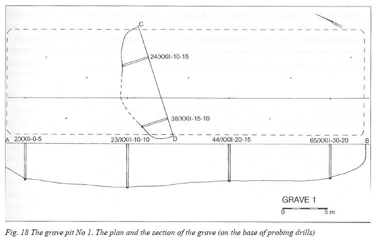
The grave pit No 1 (Fig. 18)
The grave pit No 1 was situated in the north-western part of ha XXII basing on 13 deep drills (No 2, 3, 11, 18, 19, 23, 24, 37, 38, 44, 56, 65, 66). The most probably, in bottom view, it had a shape of an irregular rectangle with the size of 40,00 x 12,00 m and the depth of 4,80 m. The pit was filled with bodies in wax-fat transformation; from the depth of about 2,00 m burnt human bones and charcoal were mixed together. Such contents was already reported at the depth of about 20-30 cm from the surface. Burnt human bones and charcoal are also found in samples drilled out in the area around that pit. In the drill No 66, except human remains at the depth of 1,40 the wastes (glass, tin) were stated and at the depth of 1,70 m the drilling was stopped: Underground waters appeared at the depth of 4, 10 m. The estimated volume of the pit was about 1500 m3.
Fig. 18 The grave pit No 1. The plan and the section of the grave (on the base of probing drills)
The grave pit No 2 (Fig. 19)
It was situated in the north-eastern part of ha XXII, basing on 3 drills (No 218-220). Significant ground disturbances of non defined origin were stated around that pit. The grave reached the size of about 14,00 x 6,00 m with the depth of 2,00 m. Crematory grave with the volume of about 170 m3.
Fig. 19 The grave pit No 2. The plan and the section of the grave
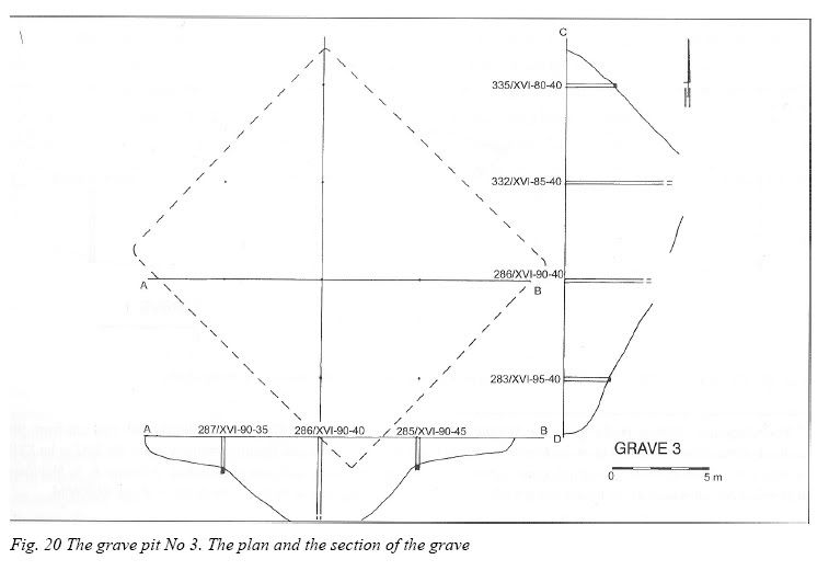
The grave pit No 3 (Fig. 20)
Situated in the southern part of ha XVI, basing on 9 deep drills. (No 283-287, 331-333, 335) In bottom view it had a shape close to a square with the size of 16,00 x 15,00 m, and the depth of over 5,00 m. Underground at the depth of 4,80 m. The contents of the pit is mixed - from about 20 cm from the top to the depth of about 4,00 m crematory contents with charcoal appears; a layer of bodies in wax-fat transformation below. The drills were stopped at the depth of ca 4,00 m. The remains of crematory character were scattered around the pit. The volume of the pit is about 960 m3.
Fig. 20 The grave pit No 3. The plan and the section of the grave
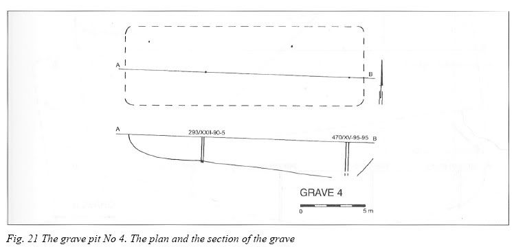
The grave pit No 4 (Fig. 21)
The pit was registered at the borderline of ha XV and XVI in their southern part. It was estimated on the base of 4 deep drills (No 293, 294, 406, 407). A small amount of crematory remains scattered around reported. The grave was in a shape of a rectangle with the size of about 16,00 x 6,00 m. The drilling was given up here at the depth of 2,30 m, because of a layer of bodies in wax-fat transformation. Above crematory remains mixed with charcoal were placed. The volume of a crematory part is of about 250 m3, the total grave body has not been estimated.
Fig. 21 The grave pit No 4. The plan and the section of the grave
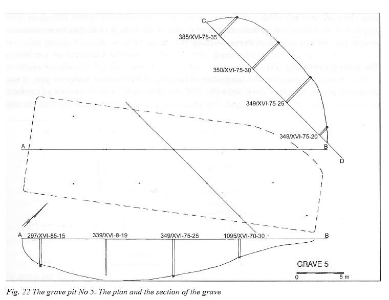
The grave pit No 5 (Fig. 22)
It was located in the south-western part of ha XVI. The range of the grave was estimated on the base of 12 deep drills (No 297, 298, 338, 339, 340, 348, 349, 350, 1095, 1096, 1097, 1099). The grave had a shape of irregular, lengthened rectangle with the size of 32,00 x 10,00 m, reaching the depth of over 4,50 m. It was of a homogenous contents. Studying the structure of it crematory layers and levelling ones were registered, which suggests multiple filling the grave with burnt relicts (compare particularly the sites No 1096 and 1097). The layer with the biggest thickness and intensity of crematory contents appeared in the lowest part of the pit and was about 1,00 m thick; above 50 cm thick layer of soil, 4 following layers of crematory remains appeared, separated from each other with 20-30 cm layers of sand. The volume of the pit is about 1350 m3.
Fig. 22 The grave pit No 5. The plan and the section of the grave
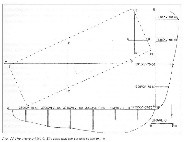
The grave pit No 6 (Fig. 23)
That grave was found in the south-central part of ha XVI. It was estimated basing on 12 deep drills (No 388-393, 1399, 1419, 1427, 1433-1435). It has a shape of a lengthened rectangle with the size of 30,00 x 10,00 m and the depth of 4,00 m. The ashes were scattered around the grave, reaching the depth of 1,00 m, according to the drill studies. It is homogenous crematory contents. The volume of it is about 1200 m3.
Fig. 23 The grave pit No 6. The plan and the section of the grave
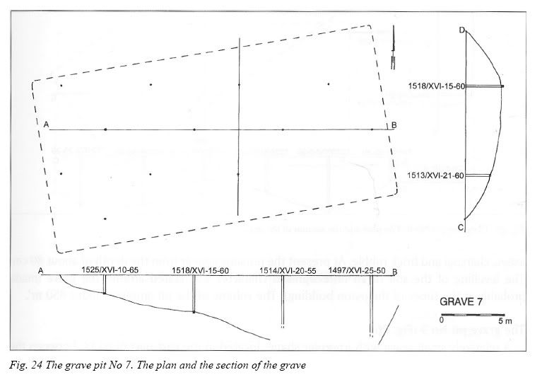
The grave pit No 7 (Fig. 24)
The grave was located in the north-central part of ha XVII. It is at present a place over which one of the pylons, commemorating the camp victims, erected in the 60s, was situated (the one farthest to the East). The area of the pit was estimated on the base of 12 deep drills (No 402, 1495-1498, 1513-1515,1517-1519, 1525 ). The traces of soil mixed with crematory remains were stated close to the pit. The pit was in shape close to a high trapezoid with the base sizes 13,00 and 14,00 m and the height of about 27 m. The depth of the pit was over 4,50 m. The grave is homogenous with crematory remains. All the drills confirmed considerably crematory ashes and sand. The lowest layer (not drilled till the very bottom) with the thickness of over 1,50 m contained the most intensive traces of body ashes. The upper layers contained as well brick rubble and stones (in the drill No 1515 at the depth of 0,80 m the works were stopped, because of rubble appearance). The volume of the grave is about 1600 m3.
Fig. 24 The grave pit No 7. The plan and the section of the grave
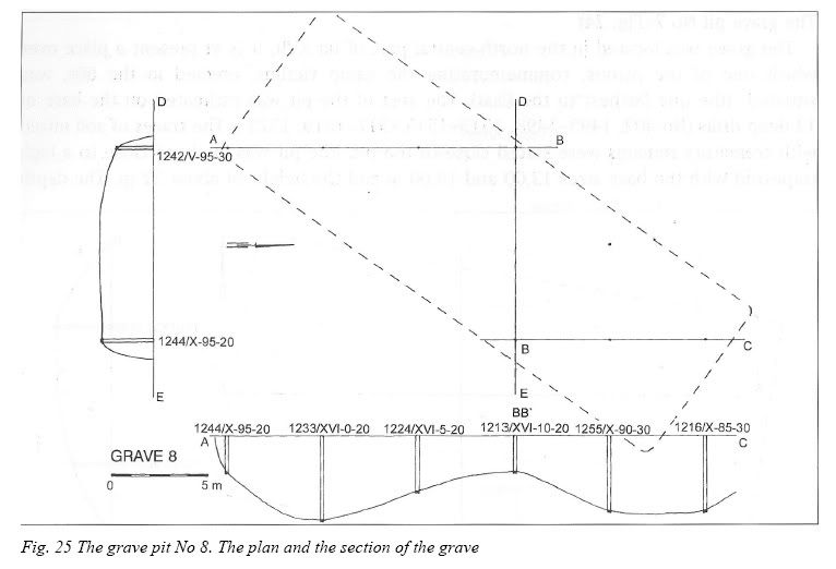
The grave pit No 8 (Fig. 25)
The grave was estimated in the south-western part of ha X. The second pylon from the 60s (counting from the east side) was erected over it. The grave was situated basing on 8 deep drills ( No 1213, 1224, 1233, 1234, 1242, 1244, 1254, 1261). The general size of the bottom view in the shape of a lengthened rectangle amounts about 28,00 x 10,00 m. The analysis of the depth of particular drills indicates that originally 2 neighbouring graves existed, joined together in one in later times. The depth of the original graves was of about 4,00 m, and their bottom parts with thickness of about 2,00 m consisted of dense crematory remains. The fillings were covered with 20-30 cm layer of sand, coming probably from the soil part separating the graves. The ditch created that way, with the depth of 2,00 m was filled with body ashes, charcoal and brick rubble. At present the remains appear from the depth of about 80 cm. The levelling of the soil of an unrecognised character was stated around the grave (made probably at the times of the pylon building). The volume of the pit amounts about 850 m3.
Fig. 25 The grave pit No 8. The plan and the section of the grave
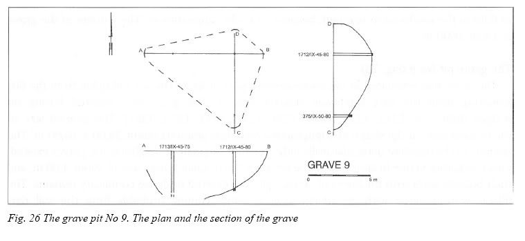
The grave pit No 9 (Fig. 26)
A relatively small grave with irregular shape, located in the east part of ha IX, between the pylon, built the farthest to the west, and present line of the camp enclosure. The pit was estimated basing on 3 deep drills (No 375, 1712, 1713). Irregular shape of the grave reached the size of 8,00 x 10,00 m. The depth exceeds 3,80 m. The contents are crematory remains and charcoal. The part of sand is observed in the grave layers (the result of purpose action or natural lowering the pit's walls). The estimated volume of the grave amounts about 280 m3.
Fig. 26 The grave pit No 9. The plan and the section of the grave
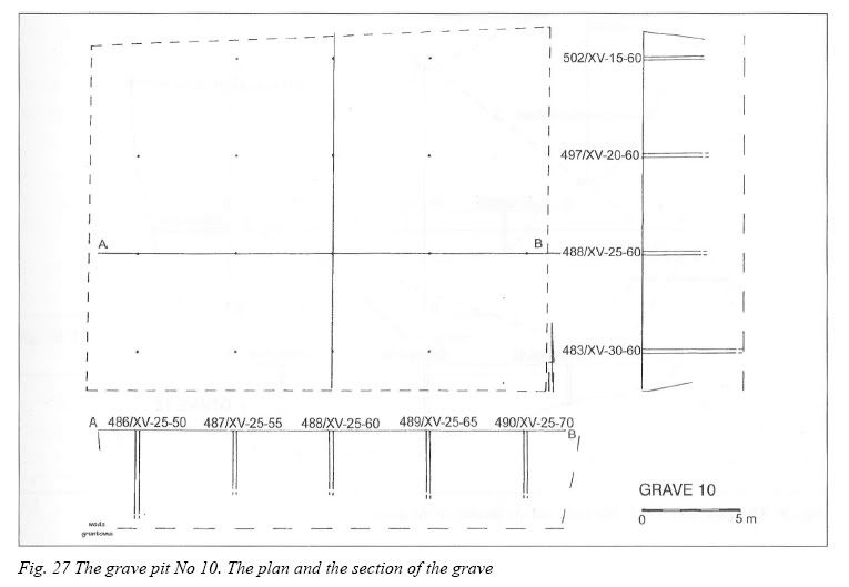
The grave pit No 10 (Fig. 27)
One of the biggest graves, in bottom view of a rectangular shape with the size of about 24,00 x 18,00 m. Situated in the north-central part of ha XV, basing on 16 deep drills (No 482-490, 494, 496-499, 501, 520); in some neighbourhood, much more shallow drills (with the ground bottom of about 1,50 m) crematory remains were reported. The grave was very deep (the drills in particular places were stopped at the depth of 4,25 to 5,20 m, because of bodies in wax-fat transformation and underground waters presence). One drill (No 483) at the depth of 4,40 m revealed the appearance of several cm layer of white sand mixed with rich lime. Over body layers there were some levels of crematory remains mixed with charcoal in turn with layers of sandy soil (20 cm). The edge parts of the pit are filled shallow, to the depth of about 1,50 m, probably because of getting some soil to make next layers between the bodies. That fact caused widening of the gravewhich was filled with next body remains. The estimated volume of the grave amounts about 2100 m3.
Fig. 27 The grave pit No 10. The plan and the section of the grave
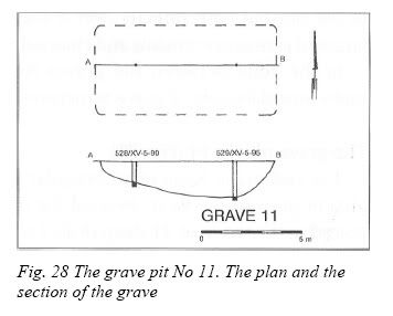
The grave pit No 11 (Fig. 28)
The grave of a relatively small volume located in the north-eastern corner of ha XV estimated on the base of only 1 deep drill (No 529) and two neighbouring ones, shallow (No 510, 528). The size is 9,00 x 5,00 m with the depth up to 1,90 m. Rather a small layer of crematory remains appears; at the depth of about 50 cm remains of musty wood were stated. The estimated volume of the grave amounts about 80 m3.
Fig. 28 The grave pit No 11. The plan and the section of the grave
The grave pit No 12 (Fig. 29)
The ditch irregular in shape, registered at the border of ha IX and XV, located on the base of 6 deep drills (No 539, 579, 1546-1549) and several shallow ones. The irregular trapezoid's edges are as follows; 6,00, 16,00, 11,00, 5,00 and 18,00 m. The depth reaches below 4,00 m. The grave contains only crematory remains in some layers. In separating layers charcoal and brick rubble was stated. The similar contents was reported in shallow drills as well. The volume of the grave amounts about 400 m3.
Fig. 29 The grave pit No 12. The plan and the section of the grave
The grave pit No 13 (Fig. 30)
It was situated towards the west of the grave No 12, also on the border of ha IX and XV. One of the concrete ever-burning fires from the 60s is placed over it. The burial place was estimated on the base of 9 deep drills (No 562-564, 577, 578, 580, 582, 585). In bottom views the grave has a shape of trapezoid with the base of 12,50 and 11,00 m and the height of 17,00 m, with the depth reaching up to 4,80 m. The contents is of body remains of mixed character. There is a layer of bodies in wax-fat transformation with thickness of about 1,00 m in the bottom part; directly over it there is a layer of sand and lime. Above there are some layers of crematory remains and charcoal. The volume of the grave is estimated for about 920 m3. In the zone between the graves No 12, 13, 14, 24 in surface layers the drills showed numerous damages of grave structures, probably caused by levelling works or robbery digs.
Fig. 30 The grave pit No 13. The plan and the section of the grave
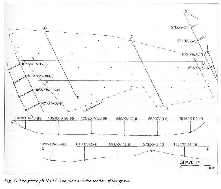
The grave pit No 14 (Fig. 31)
The vast grave basin of an irregular shape located in the western part of the fenced camp area (it goes to the west, beyond the present area) in ha IX, XIV and XV. The grave was estimated on the base of 41 deep drills ( No 566-574, 586-592, 608-611, 629, 630, 1048-1060, 1553-1558). Its length came to 37,00 m, with the approximate width of about 10,00 m. The average depth of the grave was about 5,00 m. Because of a big size of the ditch and its variety in depth one can suppose that originally there were several neighbouring pits, destroyed during placing next crematory layers over them. The drills fillings contained numerous impurities (pieces of vessel glass, plastic). The crematory remains appear in the grave directly under the soil surface. The grave's volume is over 1850 m3.
Fig. 31 The grave pit No 14. The plan and the section of the grave
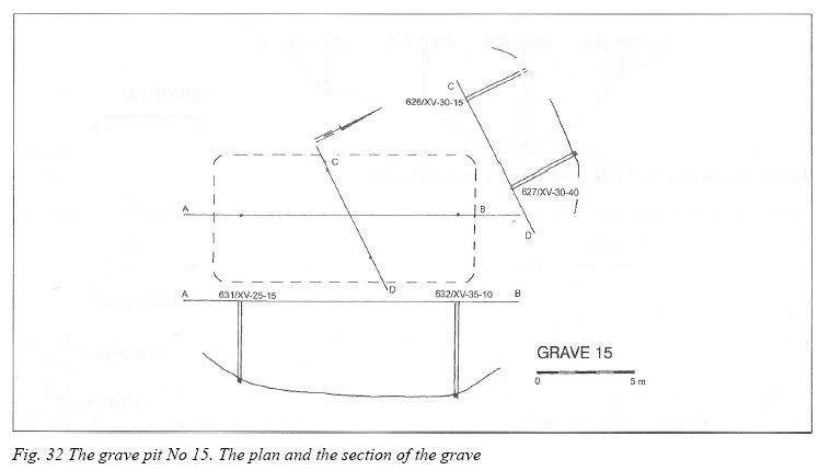
The grave pit No 15 (Fig. 32)
The grave was separated directly to the east from the previous one, in the north western part of ha XV. There is the second concrete ever-burning fire on its surface (counting from the south). The grave was estimated on the base of 4 deep drills (No 613, 626-628), and some neighbouring drills, in which rather shallow layers were located. It was in a shape of a rectangle, with the size of about 13,50 x 6,50 m and reached the depth of about 4,50 m. The grave contains only crematory remains with their highest concentration in the bottom part. The estimated volume of it is about 400 m3.
Fig. 32 The grave pit No 15. The plan and the section of the grave
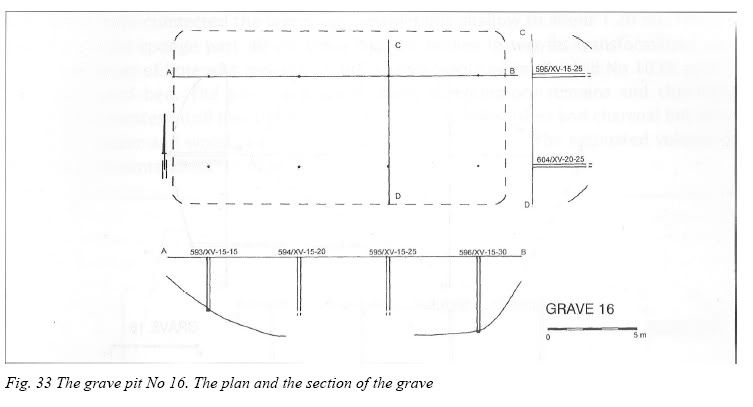
The grave pit No 16 (Fig. 33)
It was located in the north-western part of ha XV, under the third existing concrete everburning fire (counting from the south). The grave was located basing on 8 deep drills (No 593-596, 603-606). It had a shape of a rectangle with the size of 18,50 x 9,50 m and the depth of about 4,00 m. In the bottom layers lime presence was estimated (it was measured in 2 probing drills made to the ground bed). The grave contained crematory ashes in layers with sand. The shallow drills made close to the grave confirmed presence of burnt bones. The same structure of the grave contents was stated in the close to the surface layers as well. The volume of the grave amounts about 700 m3.
Fig. 33 The grave pit No 16. The plan and the section of the grave
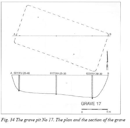
The grave pit No 17 (Fig. 34)
It was situated in the east from the grave No 16 in ha XV, estimated basing on 5 deep drills (No 601, 616, 617, 618, 623); drills made in a direct neighbourhood confirmed crematory ashes placed in shallow layers, too. The grave had a shape of a rectangle with the size of 17,00 x 7,50 m, reaching the depth up to about 4,00 m. The contents is made of crematory ashes. Burnt bones are also placed in layers with sand. A layer of rich lime was reported in 3 drills at the depth of about 3,00 m. The volume of the grave amounts about 500 m3.
Fig. 34 The grave pit No 17. The plan and the section of the grave
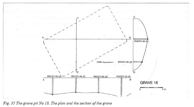
The grave pit No 18 (Fig. 35)
It was located in the eastern part of ha XV, to the east of the grave No 15, estimated on the base of 6 deep drills (No 634, 645, 646, 654, 665, 673); In the neighbourhood the shallow drills registered destroyed grave structures. In bottom view the grave was in a shape of a rectangle with the size of 16,00 x 9,00 m, with the depth of about 4,00 m. The grave contains only crematory ashes and charcoal. In the bottom part traces of lime were reported. The volume of the grave was about 570 m3.
Fig. 35 The grave pit No 18. The plan and the section of the grave
The grave pit No 19 (Fig. 36)
It was located in the eastern part of ha XV, directly under the first (counting from the south) concrete fire. The burial area was placed basing on 7 deep drills (No 648, 650-652, 667-669). The earth structures with the burial character were also reported in the neighbouring drills (the grave scattered around?). In bottom view the ditch had a shape of a square with sides of about 12,00 m. The depth is not more than 4,00 m. The grave contains crematory ashes with high density of human bones and charcoal. The volume of the grave amounts about 500 m3.
Fig. 36 The grave pit No 19. The plan and the section of the grave
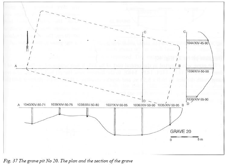
The grave pit No 20 (Fig. 37)
Separated in the western part of ha XIV on the base of 11 deep drills (No 1030, 1035 -1038, 1040-1044, 1046). The grave is situated directly to the south of the grave No 12 (the biggest of all separated here), and its western part exceeds slightly the present enclosure of the camp, reconstructed in the 60s. One can assume that the original borderline of the camp ran farther to the west. Shaped in a rectangle in bottom view, tile grave had the size of 26,00 x 11,00 m, reaching 5,00 m down in the deepest part. Within a reach of the grave 2 deep pits were reported, which made the archaeologists suppose that there had been previously 2 neighbouring graves (in the part, where the graves were connected the layers are considerably shallow to about 1,20 m). The drill No 1042 in its sponge part 40 cm thick layer of bodies in wax-fat transformation covered with a layer of lime was reported. Lime was also noticed in the drill No 1032, just above the ground bed. The grave contained layers of crematory remains and charcoal. The farthest western drill (No 1040) contained not only body ashes and charcoal but pieces of musty paper and wood, a piece of a nail and brick rubble. The estimated volume of the grave amounts about 1150 m3.
Fig. 37 The grave pit No 20. The plan and the section of the grave
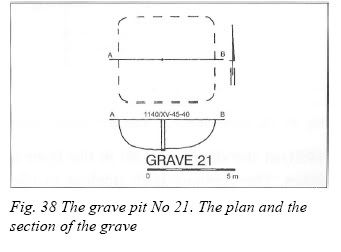
The grave pit No 21 (Fig. 38)
The grave of a relatively small surface, with the size of probably not bigger than 5,00 x 5,00 m, separated in the central part of ha XVI basing only on one, rather shallow drill (No 1140), with the depth of 1,70 m. The contents of the grave consists of crematory ashes, which were reported at the depth of 70 cm. The estimated volume of the grave amounts about 35 m3.
Fig. 38 The grave pit No 21. The plan and the section of the grave
The grave pit No 22 (Fig. 39)
The grave was separated in the eastern part of ha XVI, under the eastern end of the alley, running in front of the concrete pylons, symbolising the graves, erected in the 60s. The grave was separated on the base of 4 deep drills of the depth of about 3,50 m (No 1444, 1449, 1464, 1465). In the bottom view the grave has a shape close to a flattened triangle with the base of about 9,00 m and the height of 15,00 m. The drills made close to the grave, from its northern and western sides indicate considerably mixed layers, which probably illustrates close to the surface destruction of the grave caused by the alley building. The grave contains crematory ashes and sand. The ashes appear here not earlier than from depth of 60-70 cm. The estimated volume of the grave is about 200 m3.
Fig. 39 The grave pit No 22. The plan and the section of the grave
The grave pit No 23 (Fig. 40)
The grave was reported in the central part of ha XVI. It was separated on the base of 5 deep drills (No 1422-1424, 1439, 1440). In the bottom view the pit had a shape of a rectangle with the size of 16,0 x 8,50 m, and depth exceeding 4,00 m. In the deepest drill (No 1423) at the depth of 3,80 m the layer of lime was reported. The grave contains crematory ashes. The remains with unclear borders of layers were registered here at the depth of 1,50-2,00 m. The estimated volume of the grave amounts about 550 m3.
Fig. 40 The grave pit No 23. The plan and the section of the grave
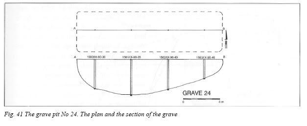
The grave pit No 24 (Fig. 41)
The grave was located in the southern part of ha IX, just to the south of fifth concrete ever-burning fire (counting from the south). The grave was separated basing on 4 deep drills (No 1560-1563). It had a shape of a lengthened rectangle with the size of 20,00 x 5,50 m, with the depth of about 5,00 m. The grave contains irregular layers of crematory ashes and lime (it appeared at the depth of 2,60 m - the drill No 1561). The lowest layer of ashes with the thickness ca 60 cm was covered here with about 40 cm thick layer of sand. Above that regular surface of body ashes and sand are reported. The estimated volume of the grave is about 520 m3.
Fig. 41 The grave pit No 24. The plan and the section of the grave
The grave pit No 25 (Fig. 42)
The grave shaped on the base of 4 deep drills (No 1581, 1582, 1597,1599) in the southern part of ha IX, under the alley, between the fifth and the sixth ever-burning fire. The surface of the grave is about 12,00 x 5,00 m. The maximum reported depth of the grave, basing on the drills reaches about 4,00 m. The contents is mixed. The bottom of the grave contains 40-50 cm layer of bodies in wax-fat transformation, covered with a lime layer. Above that there is a layer of body ashes with the thickness of about 60-8 cm, covered with 80 cm layer of sand. Over it there is another intensive layer of burnt wood with thickness 80-100 cm, covered with a surface bed of humus-like sand. The estimated volume of the grave is about 250 m3.
Fig. 42 The grave pit No 25. The plan and the section of the grave
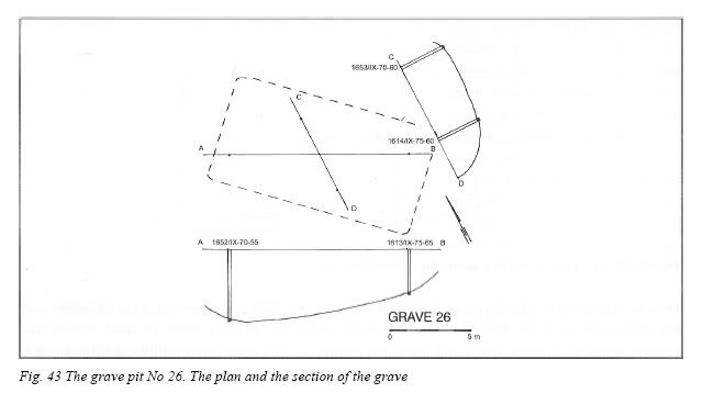
The grave pit No 26 (Fig. 43)
The grave was located to the north from the grave No 25, in the south-central part of ha IX, under the alley, close to the sixth ever-burning fire (counting from the south). The grave has a shape of a rectangle with the size of 13,00 x 7,00 m and the depth of over 4,00 m. It was located on the base of 4 deep drills (No 1613, 1614, 1652, 1653). It contains crematory ashes with clear layers of ashes, charcoal and sand. The estimated volume of the grave is about 320 m3.
Fig. 43 The grave pit No 26. The plan and the section of the grave
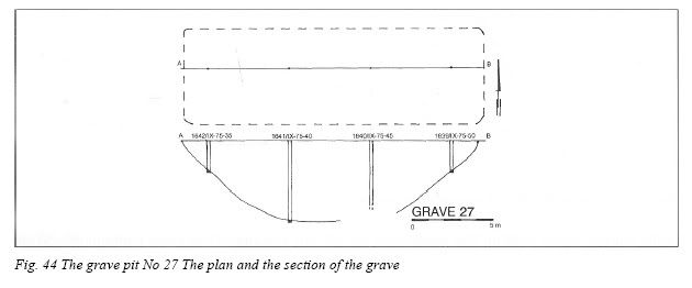
The grave pit No 27 (Fig. 44)
It was separated towards the west of the grave No 25, in the central part of ha IX, basing on 4 deep drills (No 1639-1642). In the bottom view it has a shape of a lengthened rectangle of size 18,50 x 6,00 m, with the ultimate depth reaching up to about 5,00 m. The contents has a mixed character. The bottom part consists of nearly 1 m thick layer of bodies in wax-fat transformation, over it there is 20-25 cm thick a layer of lime; above - over 2 m thick intensive layer of charcoal with the small contents of crematory ashes (similar structure was reported only in 2 middle drills). In other drills, shallow up to 2,00 m no clear stratigraphy was reported. The estimated volume of the grave was about 450 m3.
Fig. 44 The grave pit No 27 The plan and the section of the grave
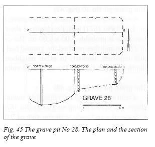
The grave pit No 28 (Fig. 45)
The grave was located towards the west from the grave No 27, in the central part of ha IX, separated on the base of only 1 deep drill (No 1647) reaching up to the depth of 5,00 m. The surface shape is difficult to define. In the drill in its bottom part 2 clear layers of bodies in wax-fat transformation covered with lime were reported; over them there are only intensive structures of charcoal without clear body ashes, noted also in 2 neighbouring drills. The volume of the grave is difficult to estimate, probably exceeding 70 m3.
Fig. 45 The grave pit No 28. The plan and the section of the grave
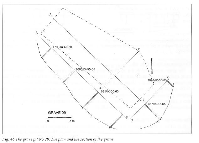
The grave pit No 29 (Fig. 46)
The grave of quite a large volume, lengthened, shaped of an irregular rectangle with the size of about 25,00 x 9,00 m and the maximum depth of about 4,50 m, located in the central part of ha IX, basing on 9 drills (No 1667, 1681, 1682, 1694-1697, 1702, 1703). The structure contains crematory ashes. In two drills presence of lime was reported (No 1667, 1695). The drills show varied stratigraphy of the grave, indicating the mixed filling of the volume of the ditch with crematory ashes structures. The estimated volume of the grave amounts about 900 m3.
Fig. 46 The grave pit No 29. The plan and the section of the grave
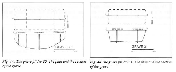
The grave pit No 30 (Fig. 47)
A relatively small crematory ashes grave, separated in the central part of ha IX, basing only on 1 drill (No 1671) with the depth of about 2,70 m. The estimated size of the grave in bottom view is probably 5,00 x 6,00 m. The crematory remains are noted only from the depth of 2,70 m and they reached the ground bed (thickness of about 1,00 m). Above that layer the drill reported, similarly to other neighbouring ones, a high density of charcoal from the depth of about 1,00 m. The estimated volume of the ditch amounts about 75 m3.
The grave pit No 31 (Fig. 48)
A relatively small grave registered towards the north from the grave No 30 in ha IX. The shape was drawn basing on 2 drills (No 1676, 1677). The grave in bottom view had probably a shape of a rectangle with the size of 9,00 x 4,00 m, reaching the depth of 2,60 m. It is crematory ashes grave. The layers mixed with sandy soil appear from the depth of about 60 cm. The estimated volume of the grave is about 90 m3.
Fig. 47 . The grave pit No 30. The plan and the section of the grave Fig. 48 The grave pit No 31. The plan and the section of the grave
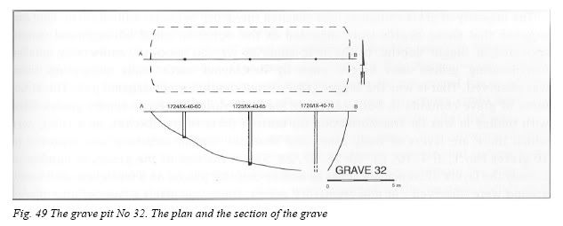
The grave pit No 32 (Fig. 49)
The grave is situated in the north-western corner of the presently enclosed area of the camp in thecentral-eastern part of ha IX. It was separated basing on 3 drills (No 1724-1726). In bottom view with the shape of a lengthened rectangle it reached the sizes of about 15,00 x 5,00 m, with the depth of over 4,00 m. The contents is mixed in structure; the bottom part contains bodies in wax-fat transformation, covered with lime at the depth of about 3,60 m. Above that appears the mixed structure of crematory ashes with charcoal. The estimated volume of the grave is about 400 m3.
Fig. 49 The grave pit No 32. The plan and the section of the grave
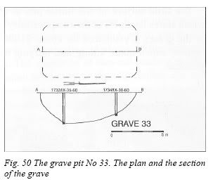
The grave pit No 33 (Fig. 50)
It is rather a small grave reported in the north-western corner of the presently existing borderline of the camp, which volume reaches beyond the fence. The grave was indicated on the base of 2 drills (No 1732, 1734). In bottom view the grave has sizes of 9,00 x 5,00 m and the depth is of about 3,00 m. The grave contains mixed remains of crematory ashes and charcoal. The estimated volume of the grave reaches about 120 m3.
Fig. 50 The grave pit No 33. The plan and the section of the grave
Planigraphy of the graves reported in the area of all the death camp in Bełżec, and their general number of 33, indicates clearly that they were located in two zones of different character. The first zone, probably the older one, contained the graves appearing one close to the other in western and north-western part of the camp. The witness S. Kozak who worked in the group of prisoners building the gas chamber used in the first stage of Jews' extermination20, informs about the presence of the mass grave, prepared by Germans in the area of the northern camp corner. That was probably the place, where they started burying the victims. Generally 21 graves were reported in that area, which makes nearly 64% of their whole number in that site. The largest graves were also registered in that part. One can not exclude, however, that several of them (reported as graves of a big volume) were previously some separated smaller ones, which borders mixed either during covering them with soil, covering the traces of the camp up after closing the camp down or result of burglary searches after the war. During the works archaeologists reported the cultural layers with the intensive changes of the ground surface, reaching as deep as about 3,00 m, which were difficult to interpret explicitly. The difficulty is additionally caused by too small density of probing drills as a base of interpretation. The present knowledge of these structures, in spite of lack of very characteristic features, typical for grave contents, can not let us regard those relicts as traces of camp buildings, either. These doubts could be probably explained during archaeological studies of the area, preferably of a wide scope character. The other zone of the graves appearance takes up the north-eastern area of the camp. 12 graves were reported here (about 36% of the total number), with more regular forms (mainly of a rectangle view), which differed from one another in size and appearing in significant scattering. In the area of those graves, transformation of ground, characteristic for the first zone does not occur at all, or very rarely. The other parts of the camp are free from graves21.
These are Prof. Andrzej Kola’s maps of the Belzec mass graves and the drills conducted therein[16]:


This is an air photograph of Belzec taken in 1944, long after the camp had been closed down[17]:

Matching Prof. Kola's maps with his analysis of wartime air photographs, Alex Bay argues that Prof. Kola did not discover all of the Nazi mass graves at Belzec[18]. Bay’s arguments and Mattogno’s related comments are discussed in earlier blogs[19].
Prof. Kola’s archaeological investigation and the construction of the Belzec memorial had as a site effects protests by Orthodox Jews who considered the works on site a desecration of the dead whose remains are all over the Belzec area. Especially sharp were the attacks by one Rabbi Weiss of New York[20], which have been addressed in several installments of my discussion with Mattogno[21]. An unfortunate long-term consequence of these protests shall be addressed in the following section.
3. Sobibor
Information about postwar investigations on the site of Sobibor extermination camp comes to us from a pamphlet published by "Revisionist" writers Carlo Mattogno, Jürgen Graf and Thomas Kues on occasion of the trial against presumed former Sobibor guard John Demjanjuk in Munich[22]. Part 13 of this pamphlet contains a German translation of an excerpt from a 1947 report by the Polish Commission for the Investigation of German Crimes in Poland ("Oboz zaglady w Sobiborze", in: Biuletyn Glownej Komisji Badania Zbrodni Niemieckich w Polsce, Nr. III, Poznan 1947), which I have translated into English:
In the middle part of the terrain, presumably at the places meant to bury the ashes, there stands a pine wood two years young, which covers an area of about 1200 m2. Excavations there revealed, below a layer of sand about half a meter deep, the presence of ash and bone splinters mixed with ash. In short distance from the camp's eastern border a pit 20 x 15 meters large with quicklime was found. On the whole camp area one finds human bones here and there. [...] For determining the camp also the results of expert analyses provide convincing proof. Thus it results from a report of the Jagiellonian University that the bones sent there for examination are human bones. From an expert report of the Institute for Forensic Medicine in Cracow it becomes apparent that the sand extracted at the grave sites is mixed with bone ash and fat.
Photos presumably related to this site inspection, or to robbery digging in the area of Sobibor extermination camp[23] can be found in the archives of the Ghetto Fighters House (captions are from that source):
"Pits in the woods near the Sobibor extermination camp, in which victims were buried"
"The woods in the area where the Sobibor extermination camp had stood"
"The woods in the area of the Sobibor extermination camp"
"The woods of Sobibor, photographed after the war"
"The woods of Sobibor, photographed after the war"
"Hair, bones and ashes found on the grounds of the Sobibor extermination camp"
"Hair, bones and ashes in the area of the Sobibor extermination camp"
Some of the remains found in the soil of Sobibor were later included in a glass display that for some time was part of a circular monument built in 1961[24]:
"A glass display case containing ashes and bones of victims of the Sobibor extermination camp"
Forty years after construction of the memorial, the Sobibor area was subject to an archaeological investigation headed by the same Prof. Andrzej Kola who had conducted the archaeological investigation at Belzec. A few photographs probably related to that archaeological investigation are available online[25] and include the following three pictures of core drilling samples extracted from the soil of Sobibor:
The white substance on the first of these core samples could be lime (the use of which alone points to presence of mass graves, for what else would lime be put in the soil for, at least in this area?), but it could also be bone ash.
The other two samples show a light-gray substance suggesting ash of human bone and tissue; the third sample also contains a black substance that could be wood ash. All these substances are clearly distinct from the light brown soil of Sobibor, which can also be seen on the photos.
These photos show just three out of the many drills whereby Prof. Kola established the location, size and contents of the mass graves surrounding the Sobibor memorial, which he described as follows in a report about his archaeological research[26]:
Grave no 1 is located in the north - eastern part of hectare 17, just west from the memorial to victims. The site was excavated by 27 drills. Horizontally, it measures 20 x 20 m and is up to 4.30 m deep. It was a body burning grave.
Grave no 2 is located in the western part of the hectare 17, south from the memorial. It was excavated by 28 drills. Horizontally its shape is irregular, measuring at least 20 x 25 m – with its longer side in NS position – and with depth up to 4 metres. It was a body burning grave.
Grave no 3 is located in the south- western part of hectare 11 and north - western part of hectare 17. It was excavated by 17 drills. Horizontally, it's irregular, measuring around 20 x 12 m - with its longer side in NS position. The biggest part of the grave is located under north - western part of the memorial. It’s up to 5.80 m deep. In bottom layers, the grave is bony, with human remains in wax- fat transformation. The upper layers are a mixture of burnt body remains with layers of lime stone, sand and charcoal. The northern part of the grave is located near to northern part of the grave no 4. The more precise location of the graves requires additional research.
Grave no 4. It’s a grave with significant size, located in southern part of hectare 11, as well as northern and central parts of hectare 18. It was excavated by 78 drills. Horizontally, in NS position, it measures 70 x 20-25 m with the depth of around 5m. In bottom layers the grave is bony, with human remains in wax- fat transformation. The upper layers are a mixture of burnt body remains with layers of lime stone, sand and charcoal.
[...]
Grave no 5. It’s not a very vast grave, located in the north-western part of hectare 18. It was excavated by 7 drills. Horizontally, it's irregular, measuring at least 10 x 12 m, with its depth up to 4.90 m. In its bottom layers the grave is bony, with human remains in wax-fat transformation. In the upper layers – burnt body remains.
Grave no 6. It’s located in the central part of hectare 18, south from grave no 5. It was excavated by 22 drills. Horizontally, it’s irregular, measuring at least 15 x 25 m, with its depth up to 3.05 m. In its bottom layers the grave is bony, with human remains in wax-fat transformation. The upper layers - burnt body remains.
Grave no 7. Location of body burning activity, measuring at least 10 x 3 m, with its depth up to 0.90 m, in the central part of hectare 18, around 10-12 m south from the southern side of grave 4. The vast majority of burnt body remains were found in 6 drills. Around, vast ground transformation of an uncertain genesis. Only because of the burnt body remains found, the structure was thought of as a grave. In order to state the function of the place more accurately, further archaeological research needs to be conducted.
Prof. Kola’s findings about the location and shape of the mass graves, which are plotted on two maps on pages 122 and 123 of the cited publication:


are corroborated by the coincidence of some of these graves with greener areas clearly visible on a satellite photograph of the Sobibor memorial area, as was pointed out in an earlier blog[27]:

 .
. They are also corroborated by air photos taken by members of the current Sobibor Archaeological Project[28].
Prof. Kola’s descriptions of the Sobibor mass graves contain the information required to calculate their volume and the volume available for burial, the latter using the same assumptions as were applied in regard to the mass graves at Chelmno (click to enlarge table):

One notes that, although the area of the mass graves is significantly smaller than at Chelmno (3,240 vs. 5,393 square meters), the volume and the volume available for burial are not much smaller (14,745.8 vs. 16,179.0 respectively 10,027.2 vs. 11,001.7 cubic meters). This is because most of the Sobibor graves were much deeper than the Chelmno graves.
According to Prof. Kola’s description, three of the mass graves – nos. 1, 2 and 7 – were mere body-burning graves, never used to bury whole corpses. The graves used for burying corpses, graves nos. 3, 4, 5 and 6, have a total volume available for burial of 7,479.2 cubic meters. At the concentration of ca. 11 bodies per cubic meter calculated by Alex Bay (which, as we have seen, is conservative for a malnourished population largely consisting of children), these four graves could thus take in over 80,000 dead bodies, i.e. the number of deportees killed at Sobibor before the camp administration decided to stop burying the corpses and to burn them instead [29].
Readers may wonder what "Revisionist" propagandists Mattogno, Graf and Kues argue against Prof. Kola's findings, especially as concerns the size and capacity of the mass graves at Sobibor and the human remains found therein.
The first thing these authors do on page 13 of their pamphlet is try to explain the corpses in wax-fat transformation at the bottom of the graves as belonging to the Jews killed during the camp revolt on 14 October 1943[30], who are supposed to have been buried and not burned because the body-burning had already been concluded at that time. I guess that's why these bodies are lying not on top of the cremation remains of earlier corpses (as they would if MGK’s explanation stood a chance of being accurate), but below such cremation remains at the bottom of these graves. Unless we are asked to believe that the SS dug up the ashes and bone fragments already inside the graves in order to place the bodies of those shot below, it seems that the trio of "Revisionist" scions forgot to think before writing. They also don’t explain why on earth one would need to bury a few hundred corpses up to 5.80 meters below ground (moreover in four graves), or why graves with such enormous depths needed to be there in the first place.
MGK's next shot is to call in question the accuracy of Prof. Kola’s findings as concerns the depth of the graves. They refer to Prof. Kola’s description of excavations in a well "not far from the graves", which supposedly had to be stopped at a depth of 3.60 meters because of a ground water stream, as contradicting the plausibility of the graves being as deep as described by the archaeologist[31].
Prof. Kola’s description of these excavations, which is partially quoted by MGK in German translation, reads as follows in Katarzyna Piotrowska's English translation of Prof. Kola’s article (emphasis added):
Object C
(Hectare XXV, acre 35. Dig 3/01)
In the depth of around 40-45 cm below the asphalt, where the cement well was located, there was started an archaeological dig, measuring horizontally 2.3 x 2.1 m. The dig was being excavated until the depth of 95 – 100 m, uncovering – at the depth of 50 m – the upper part of the first remaining cement CEMBROWINA of the well. It was noticed that while building the well, only the sand from its interior was taken out. Hence the following exploration was taken only in its interior not in the area of the dig. The depth of 5.00 – 5.10 m was reached. The exploration had to be stopped here because of the sudden leak of ground waters, of which traces started appearing at the depth of around 3.60 m. They didn’t make it till the end of the well then.
The highlighted part is left out in MGK's quote. Of interest is the last sentence, which shows that the excavation was only stopped at the depth of 5.00 to 5.10 meters because of a ground water leak, the first traces of which started appearing at the depth of 3.60 meter but were not strong enough to stop the excavation until a depth of 5.00 to 5.10 meters had been reached. MGK obviously left out this part, which suggests that it was not impossible to dig graves up to 5 – 5.10 meters deep in other parts of the camp, even if located "not far" from the well, or even deeper than that in dry times when the groundwater level was accordingly lower[32]. This omission allowed them to misrepresent Prof. Kola’s statement to the effect that ground water had forced him to stopped digging at 3.60 meters, when actually diggings only had to be stopped at a depth of 5.00 to 5.10 meters because of the ground water. Leaving out a part of a quoted text in order to give that text the meaning one would like it to have is called quote-mining. Quote-mining is a form of lying.
MGK also claim that "when A. Petcherski and his companions tried to dig an escape tunnel in October 1943, the same was flooded with water [8], which indicates a high ground water level" (my translation). The source they refer to is "A. Schelvis, Vernietigingskamp Sobibor, a.a.O., S. 181/182". "A Schelvis" must be Dutch historian Jules Schelvis, whose book about Sobibor extermination camp is available in English translation[33]. On page 152 of that translation one reads that due to "marshy soil conditions", the projected tunnel "from the Lager 1 carpenters' workshop" was to be "dug close to the surface to avoid flooding", and that one of the reasons why the tunnel turned out not be feasible was that "the terrain was too waterlogged; flooding in parts of the tunnel would be unavoidable". So Schelvis is not speaking of actual flooding but of a concern that the tunnel might be flooded[34]. This concern, as pointed out in an earlier blog[35], was not unreasonable if, as considered plausible in that blog, the water table at Sobibor had risen considerably between the initial period of the camp's operation in 1942 and October 1943. Another aspect to be taken into consideration is that the land lying near "Lager 1" ("Camp 1") seems to have had a marsh in it, which is drawn on the map made by former SS-officer Erich Bauer when testifying as a witness at the trial in Hagen, Germany[36]:

The marsh is inside the read square I drew on the map. A marsh area (horizontal blue lines) close to where "Lager 1" is also shown on a Polish topographical map of the Sobibor site as it appears today[37]:

No marsh is shown on either map in the vicinity of Camp III, the extermination area of Sobibor where the mass graves are located.
In sum, there is no reason why waterlogged soil near Camp I in October 1943 should belie the feasibility of digging mass graves up to 5.80 meters deep in Camp III during the first phase of killing operations at Sobibor, in the late spring and the summer of 1942.
The size of the graves, which they fail to explain away with they groundwater table arguments, poses a problem to MGK insofar as they cannot deny that, even with the far too low concentration of bodies per cubic meter they assume (6 adult bodies per cubic meter expanded to eight to "take into account the presence of children among the hypothetical victims" [38]), the mass graves 1 to 6 could take in 113,000 corpses[39]. So they argue that the current size of the graves is not identical with their original size as the grave structures were significantly disturbed by robbery digging, which they reason is what accounts for their current irregular shape.
While it is certain that the robbery diggers scattered human remains throughout the area, and quite possible that they somewhat disfigured the graves' original shapes, it is rather unlikely that they considerably expanded the original size of the graves, considering the enormous depth of most of them (all burial graves except grave # 6 were close to or well above 5 meters deep) and the comparatively small size of the pits made by robbery diggers, one of which seems to be what is shown on the photo captioned "Pits in the woods near the Sobibor extermination camp, in which victims were buried" in the archives of the Ghetto Fighters House:

That leaves the feeblest of MGK’s arguments in this context, which is that just because the Sobibor mass graves could "theoretically" have taken in well over 100,000 corpses (by their calculation), this doesn’t necessarily mean that this many corpses were actually buried in there.
Never mind the evidence that the SS at Sobibor and the other camps of Aktion Reinhard(t) understandably made the most of what grave space they had at their disposal, e.g. the following testimonies mentioned by Schelvis[40]:
Until the end of 1942, the bodies were taken to a Lager 3 pit, measuring about 60 by 20 meters and about 6 to 7 meters deep, the walls sloping down to prevent it from collapsing.[41] Along one side a wooden structure jutted over the edge, so that the loaded carts could be tipped over and the bodies dumped into the pit. The bodies had to be laid out by the Arbeitshäftlinge in a prescribed fashion to use all available space, and were then covered with chloride of lime.[42]
By June 1942 it had become clear to the camp leadership that the grave was filling up fast, so a second grave was dug 80 meters away from the first. Bolender testified:
The first grave had been covered with a layer of sand. As this grave was completely full, the other bodies had to be taken elsewhere, even though the new grave was not yet ready. I still clearly remember arriving for work at the second grave one morning, to find that the bodies which had already been piled up along one side had decomposed to such an extent that in the sweltering heat blood and body fluids had run all along the bottom of the unfinished grave. It was clear that we could not continue to work under such circumstances. I remember giving directions to build a kind of bank, about 30 cm high perhaps, right across the bottom of the grave. Ittner was there as well; I spoke to him about it. In this context I can also give an impression of the extent of deterioration of the bodies in the first grave. The layer of sand covering the grave cracked and rose up to the point where some of the bloated bodies were being pushed to the surface, rolling out sideways. So I had the Arbeitsjuden build a proper sand bank all around the grave. The sight of it all was intolerable, and the stench also unbearable.[43]
As Ittner, who had been working at the gas chambers for some time, stated: 'Es war mehr als eine Schweinerei dort' ('It was worse than barbaric there').[44] The stench was so intense and pungent that it permeated the air inside the little station at Sobibór, even with the windows closed. Soldiers of a security battalion in Chelm reported to their commandant that every time they neared Sobibór station on their way to Wlodawa, they were met by a most awful stench.[45]
So much for the graves' capacity being merely "theoretical". Their minds impervious to any evidence that belies their preconceived notions, the "Revisionist" scions point to the fact that in three relatively small graves excavated by the Soviets in the area of Treblinka I labor camp, the concentration of bodies was just one per cubic meter. As I pointed out in earlier blogs[46], it is hard to understand the logic whereby the lavish use of grave space in a labor camp with comparatively low mortality[47] and accordingly much lower grave space needs tells us anything at all about how grave space was used at a place where thousands of dead bodies often had to be disposed of in a single day. MGK might as well use grave space usage at a common civilian cemetery as a parameter of comparison. And they further shoot themselves in the foot with their Treblinka comparison by showing that the graves of a camp with the mortality of the Treblinka I labor camp[48] were rather small (the largest of the graves they mention was just 2.3 meters deep and had a volume of 115 cubic meters). Sobibor’s mass grave # 4 was almost 2.5 times deeper and had 68 times the volume of this Treblinka I grave. Why on earth would the SS undertake the considerable effort related to making such an enormous grave, only to then squander the grave space so laboriously created by not using it to the maximum of its capacity?[49]
Notwithstanding the pathetic absence of logic in MGK's argumentation (and its being somewhat-less-than-honest on occasion, as shown above), I expect to find it repeated in their book about Sobibor, which I’m told is due to be published this summer.
Back now from "Revisionist" propaganda to serious archaeological research. What will happen next as concerns investigation of the Sobibor mass graves (which unlike those at Belzec are still open for archaeological investigation)? In the blog I wrote following my trip to Sobibor in October 2008[50], I expressed the hope that the there would be excavations of the Sobibor mass graves, bringing their contents to the surface, thoroughly examining and documenting them and thereby striking a deadly blow to "Revisionist" charlatanry. Unfortunately, and apparently due to the religiously motivated protests of Rabbi Weiss, excavation seems to be a remote possibility at the moment, according to Gilead, Haimi and Mazurek[51]:
That Kola was allowed to drill mass graves is considered by Orthodox Jews as ‘a monumental failure’ (Weiss, 2003). As it stands now, it seems that mass graves at the Nazi extermination centres will not be excavated in the foreseeable future. Information regarding their location and extension will be obtained by remote imagery and non-invasive geophysical methods that are standard tools of forensic archaeology (Cheetham et al., 2007: 196-206).
If my hope has not been wholly crushed by religion, this is due to the amazing things that remote imagery and non-invasive geophysical technology can do these days, as I have gathered from Skype conversations with Israeli archaeologist Yoram Haimi, one of the authors of the above-quoted article. I am thus looking forward to reports about the Sobibor Archaeological Project's further progress.
4. Treblinka
The site of Treblinka extermination camp (also known as Treblinka II, Treblinka I being the nearby labor camp) was first investigated on August 22-24, 1944 by members of a Soviet commission headed by Military Examining Judge of the Military Office of Prosecution First Lieutenant of Justice Jurowski. Mattogno and Graf quote translated parts of this commission’s report in their Treblinka book[52]. Unless there is something to the contrary in parts of the report that these authors (who, as was shown in the previous section, are not disinclined to quote-mining) did not quote, the Soviet commission conducted no excavations in areas containing mass graves, though they mentioned wood and human ashes remains lying all over the place:
A huge area of the camp was covered with cinders and ashes. The road, which connected the two camps and is three kilometers long, was covered with cinders and ashes to a height of 7 - 10 cm. One could recognize the presence of lime in large pieces of cinder with the naked eye. It is well known that lime is a product of burning bones. There were no production sites in the camp, but cinders and ashes were brought out of the camp every day by the ton. This freight was loaded onto railroad cars, and 20 to 30 peasant carts distributed them and poured them onto the road. (Witness testimony of Lucjan Puchała, Kazimierz Skarzinski. Stanisław Krym inter alia).
The statements of the witnesses, the book ‘One Year in Treblinka’ [by Jankiel Wiernik], the presence of a large quantity of ashes and cinders, the presence of personal commodities and documents strewn on the grounds as well as excavated from the pits confirm that there were ovens in the camp where people were cremated.
[…]
Remaining as marks of the existence of the camp are: an abatis of barbed wire, ashes, cinders, and a great number of pits, where household objects of the cremated Jews have been buried.
The reasons why the Soviets didn’t excavate in mass grave areas can only be speculated. The report suggest that the investigators were more interested in documents and other items left behind by the victims, and they may have seen no point in excavating for what they expected to find in the mass graves according to the depositions of eyewitnesses they had interrogated (i.e. cremation remains but no whole human corpses), which they could see with the naked eye on the site anyway.
The partially quoted report of a later Polish-Soviet commission dated 15 September 1944 also suggests that no mass grave areas were excavated, if MG can be trusted not to have left out anything to the contrary[53].
The next inspection of the site was conducted more than a year later, on 6 November 1945, by a delegation of the Jewish Central Historical Commission consisting of Rachel Auerbach and Józef Kermisz, together with Judge Zdzisław Łukaszkiewicz, State Prosecutor J. Maciejewski, several witnesses, the president of the district council of Siedlce, the mayor of the neighboring village Wólka Okrąglik and a photographer by the name of Jakob Byk. Of this inspection Rachel Auerbach left a vivid account, which especially highlights the devastation of what was obviously the Treblinka mass graves area by robbery diggers[54]:
We must remember that the killing of Jews was primarily a crime of robbery with murder. The utilization of gold and valuables, like that of all the other Jewish property, and the entire process of "Werterfassung" at Treblinka, was organized in a first-rate manner from the very start. Jewelers were brought in from Germany to supervise the assorting of the cash and the valuables. One of these persons, the Treblinka veterans report, was "quite a decent Yekke"("decent" because he had never tormented Jews without cause and always tried to see to it that the Jews who worked for him would not be subjected to the selections), who hailed from Leipzig. Together with his "Goldjuden" (literally "gold Jews") he selected, appraised, and weighed and packed suitcase after suitcase of diamonds, jewelry, gold pieces and foreign currency. From time to time he would load the valises onto trucks and send them under escort to Lublin, perhaps subject to the order of SS General and Brigadeführer Globocnik, or to be sent on by Globocnik for government requirements, or for the personal use of the cabinet ministers and Reichsführer in Berlin.
It is not difficult to imagine that those who had played a predom¬inant role in procuring this source of revenue were properly re¬warded for their troubles.
It is easy to picture how the Globocniks and Himmlers would exchange gifts and favors. Less "official" but no less substantial were the "nice gifts" which the German and Ukrainian SS men gathered up and sent out for their own account; the heavy rings, the fine watches. Such things didn’t drop into their pockets just like peanuts!
The ones to benefit the least from property left behind by Jewish deportees were the Jews who arrived after them. It is true that they also tried to get their hands on some of it; with the help of Ukrainians who had been bribed, the Jews who worked in the woods bought food in the neighboring villages for good foreign currency, at skyrocketing prices.
Jews who managed to escape often took something out with them. But most of the time they were robbed of everything on the way–sometimes of life itself. And so plenty of robbers grew rich in that area.
And now that it’s all over, that the camp had been burned down and everything carried off, what hope is there for treasure now? Plenty!
Those in the know are aware that not all the dead were cremated and that, aside from those who were buried naked, Jews in some places were buried fully dressed without their pockets being searched, their hidden valuables undiscovered-secret wealth, sewn into their clothes. In some cases the posthumous "Werterfassung" did not include the extraction of gold teeth. And in fact there had been people lying in wait to dig in the soil for gold teeth, clothing and other treasures buried there by Jewish workers.
All kinds of scavengers and marauders come here in droves, shovels in hand. They dig, search and ransack; they sift the sand, they drag parts of half-rotted corpses from the earth, bones and scattered refuse in the hope that they may come upon at least a coin or a gold tooth. These human jackals and hyenas bring along live artillery shells and unexploded bombs. They explode several of them at once, tearing huge craters into the desecrated, blood-drenched soil which is commingled with the ashes of Jews.
The Sandy Soil Yields Up Its Secret. Our car came to a stop. We got out: this was where the camp area began. According to our measurements, it is 15 hectares. A well-paved road runs parallel to the railroad tracks for about 1½ kilometers and then comes to a dead end. Another road branches out from it and comes to an end even sooner. The surface of both roads contains a weird mixture of coals and ashes from the pyres where the corpses of the inmates were cremated. The second road leads in the same direction as the “Road to Heaven,” of which no trace is now left. Just a bit of the concrete foundations of a horses’ stable - this is all that is left today of the camp buildings, the barbed wire fences, the barracks, the watchtowers, the gas chambers. Some of the buildings were burned down during the uprising, and the rest were carried off by human scavengers from neighboring villages after the arrival of the Red Army.
While the Germans were still here, the whole area had been plowed up and sown with lupine grass. And the lupine grass really grew and covered the whole surface with a green mask. It looked as if all the traces of crime had been wiped away. But since then, during the past year, the human jackals and hyenas have been coming to the burial ground and here is the picture that we saw:
Here and there, like patches of grass near the seashore, half¬ covered by the shifting sands, there were still little clumps of with¬ered lupine. Not one level place in the whole area. Everything had been torn up and dug up, little hills and holes. And upon them, beneath them, and among them, all sorts of objects. Aluminum kettles and pans, enameled tin pots-blackened, dented, full of holes. Combs with teeth broken off, half-rotted soles from ladies' summer sandals, broken mirrors, leather billfolds. All this is near the station platform where the camp’s first barbed wire fences had been.
We began our tour at the place where the transports had been unloaded, and we continued on the road which the Jews who were brought here had followed. What we saw here was the remnants of the Treblinka "Werterfassung." Remnants of the huge piles of Jewish property which had been packed up and sent away, incinerated, cleared off, and yet still could not be completely cleared away. It was not possible to clear away every trace of what the hundreds of thousands of people who had passed through there had experienced. Here was the physical evidence; here were the corpora delicti.
Perhaps someone might wonder what sort of people they were who left such plentiful evidence of their truncated lives, to what nation they belonged. Well, look about you and you will see it for yourself:
Twisted Sabbath candlesticks-enough for whole collections. A scrap from a prayer shawl. just dug out of the ground, lying white and fresh, complete with a blue Star of David, is an elegant Warsaw armband (from the corner of Karmelicka and Leszno–the latest fashion in the ghetto). A whole pile of ladies’ marriage wigs.
These must be unburned, stray remnants from some store.
The hair shorn off the living women had been turned into indus¬trial raw materials, but it seems that the ritual wigs of the old, pious Jewish women had been set aside for better uses. Perhaps they could be sold, by way of a friendly "neutral" country, to Jews in America, for a good price, along with the Torah scrolls and Talmudic folios which had been carefully accumulated for this purpose, packed in cases and hidden away?
But the physical evidence was not limited to objects. As we moved further into the grounds, we walked over a field which was sown with human bones.
The bombs had uncovered the contents of the desecrated soil. Leg bones, ribs, pieces of spine, skulls big and small, short, and long, round and flat.
Skulls! ...
If only we could get an ethnologist to come here!
He could have made the most accurate anthropological meas¬urements relating to the racial features of the Jewish people.
Or perhaps what was needed here would be a philosopher; a thinker, a Prince Hamlet of Denmark to stand up and deliver a gravedigger’s speech, to look upon those skulls and speak directly to them.
"Anybody have a bag? Is there a bag around here? Let’s take a bagful of bones with us!"
In a minute, a pile of bones had been scraped together. But there was no bag around and so we couldn’t take any of the bones.
But then how much could one bag have held? What with all the cremations, we could have taken out whole carloads from there. If bones can be classed as relics, then Treblinka held relics sufficient to supply the entire Jewish people.
This Is My Child’s Foot! The further we went, the heavier the air became with the smell of death. We had already passed through the famous "grove," the sparse pine trees through which the "Road to Heaven" had run. We were now standing where the gas cham¬bers had been, the huge mass graves and the pyres. In some places, the smell of death was still mingled with the odor of fire. Indeed, here and there we could see little piles of white ashes along with blackened bones, heaps of soot. All this had been buried several meters deep in the soil, mixed with sand and covered with more sand, but the explosions had brought it to the surface again. In one place the simultaneous explosion of several bombs had created a huge crater. Deep down in the hole, some outlines could be dimly seen through the fog.
"Those aren’t just bones," says the district attorney. "There are still pieces of half-rotted corpses lying there, bunches of intestines."
By now the district attorney and the judge knew every nook and cranny here. They had been conducting their investigation for some time. They had examined both Jewish and non-Jewish wit¬nesses, taken measurements and carried out minor excavations.
The Treblinka veterans were running back and forth, pointing things out, arguing with one another. They made mistakes and then began to remember the places again. They wanted to do something, to make some extravagant gestures, that would at least reflect their emotions, bound up as they were with this place. They wanted to gather bones. They leaped into ditches, reached their bare hands into rotted masses of corpses to show they were not repelled.
They did the right thing. Now we were just like the Muslim sectarians who carried their dead along in their caravans to Mecca, considering it their sacred duty to bear the smell of death with patience and love as they went along the road. That was how we felt in these fields, where there lay the last remains of our martyrs.
"Look there, at the edge of that hole," said the judge, "these are bones from a child’s leg!" One of the Treblinka survivors rushed over. "Be careful!" said another. "There’s still some flesh hanging from that leg!" But the one who had taken it was wrapping it up into a newspaper with much the same reverence as a pious Jew wrapping up an etrog [the citron fruit which is used in the Feast of Tabernacles and must remain unblemished]. He wrapped it with the skirt of his coat, then put it into his breast pocket and hugged it to his breast.
The signs of intensive robbery-digging are also mentioned in Judge Zdzisław Łukaszkiewicz' report about the examination of the site and excavations he undertook shortly after the aforementioned inspection, between 9 and 13 November 1945, though he preferred not to mention where the bombs and bomb craters he encountered came from, probably in order to keep himself out of trouble. For Soviet troops were taking part in the scavenging, bringing along mines and blind bombs from nearby Ceranów airport and setting them off in the mass graves to make easier their search for treasures they expected to have been buried along with the victims.[55] Considering the constraints he was working under, Łukaszkiewicz did a thorough examination, as is acknowledged even by Mattogno & Graf, who provide what they claim to be a complete translation of the report of 13 November 1945 signed by Examining Judge Łukaszkiewicz and State Attorney Maciejewski[56]. M&G also quote parts of Łukaszkiewicz' protocol dated 29 December 1945, which was presented by the Soviets at the Nuremberg Trial as Document USSR-344[57]. All these quotes are transcribed in an earlier blog[58], so in the following I shall only quote the parts of Łukaszkiewicz' reports highlighted in that blog.
From the report of 13 November 1945:
The largest of the craters produced by explosions (numerous fragments attest to the fact that these explosions were set off by bombs), which is at maximum 6 meters deep and has a diameter of about 25 meters – its walls give recognizable evidence of the presence of a large quantity of ashes as well as human remains – was further excavated in order to discover the depth of the pit in this part of the camp. Numerous human remains were found by these excavations, partially still in a state of decomposition.[208] The soil consists of ashes interspersed with sand, is of a dark gray color and granulous in form. During the excavations, the soil gave off an intense odor of burning and decay. At a depth of 7.5 meters the bottom was reached, which consisted of layers of unmixed sand. At this point the digging was stopped here.
From the report of 29 November 1945:
In the northwestern section of the area, the surface is covered for about 2 hectares by a mixture of ashes and sand. In this mixture, one finds countless human bones, often still covered with tissue remains, which are in a condition of decomposition. During the inspection, which I made with the assistance of an expert in forensic medicine, it was determined that the ashes are without any doubt of human origin (remains of cremated human bones). The examination of human skulls could discover no trace of« wounding. At a distance of some 100 m, there is now an unpleasant odor of burning and decay.
In the aforementioned blog I pointed out that M&G, who claimed that Łukaszkiewicz' investigations had failed to produce evidence of mass murder, obviously failed to take into account what the depth of the crater in which Łukaszkiewicz' ordered further excavations "to discover the depth of the pit[s][59]in this part of the camp" (7.5 meters!) and the size of the area he found to be covered by human ashes and larger partial human remains, which was obviously the burial area or one of the burial areas of the Treblinka extermination camp sector (2 hectares = 20,000 square meters) – revealed about the enormous amount of burial space that had existed at that camp:
For if on this area of ca. 20.000 square meters
• there were only ten graves with the measurements 50 x 25 meters, or a smaller number of larger graves covering an equivalent area, still leaving 7,500 square meters to enable movement in between the graves,
• each of these graves was only 7.5 meters deep, and
• no more than 8 bodies per cubic meter (a density considered possible by Mattogno, which seems rather conservative considering the calculations of Alex Bay and the experiment of Charles Provan, mentioned in my article on episodes 11 and 12 of the Ugly Voice Productions video) were buried in these mass graves,
the capacity of said graves was 50 x 25 x 10 x 7,5 = 93,750 cubic meters or 93,750 x 8 = 750,000 human bodies.
Of course this is a simplified calculation, which does not consider the presumable sloping of the mass graves and the thin layers of sand or quicklime that were scattered in between or above the bodies on the one hand and the volume reduction of the bodies in the lower layers due to the effect of decomposition and/or quicklime on the other (after all the bodies were not all thrown into the graves at the same time, and those in the lower layers can be expected to have considerably shrunk due to decomposition and/or quicklime by the time those in the upper layers were added, as was also pointed out in Section 4.1 of my article Carlo Mattogno on Belzec Archaeological Research ).
But I think it sufficient to show how Carlo Mattogno, though less shy than other "Revisionists" to show evidence that goes against his articles of faith, only sees or addresses those parts of such evidence that said articles of faith allow him to see or address.
The aspect of the Treblinka site and the robbery digging there is also conveyed by Karol Ogrodowczyk, member of a delegation from Warsaw that inspected the site[60]:
"The fields are dug up and rummaged through, the pits are about 10 meters deep, bones are lying around and objects of all kinds, shoes, spoons, forks, chandeliers, hair of wigs worn by Jewesses. In the air hangs the stench of decomposing corpses. … The foul smell so numbed me and my colleagues that we vomited and felt an unusual rasping in the throat. (...) Under every tree seekers of gold and gems have dug holes (...) Between the trees cavort local peasants, eager to find treasures. When we ask them 'What are you doing here?' they give no answer."
A number of photos illustrating the above-quoted descriptions of the Treblinka site are included in my collection called Photographic documentation of Nazi crimes (photos numbered 1.1.79, 1.1.84, 1.1.85, 1.3.1 to 1.3.7, 2.7.1 and 2.7.2).
Neither of the aforementioned investigations provided information about the number of mass graves and the shape and size of each of them, and as there were no subsequent archaeological investigations like those carried out at Chelmno, Belzec and Sobibor, this means that of the four Nazi camps dedicated solely to extermination, the one that killed about as many people as the other three together is sadly the one that least is known about as concerns the location, shape and size of its mass graves. What can be established on hand of
(i) a contemporary map related to Łukaszkiewicz investigation[61]:

(ii) an air photograph taken in September 1944[62]:

(iii) a present-day air photograph[63]:

and
(iv) the fact that, according to Polish historian Martina Rusiniak, the memorial built on the Treblinka site was shaped so as to avoid further robbery digging[64] (i.e. presumably so as to cover the areas where robbery-digging was most intense, which would especially be the areas containing human remains), is the following:
a) The area described in Łukaszkiewicz’ report of 29 December as covered by human ashes and larger partial human remains was the area called "area of cremation" on the 1945 survey map. Its size was not 2 hectares (20,000 square meters) but 1.8 hectares (18,000 square meters) – Łukaszkiewicz apparently rounded the land surveyor's measurements upward to the nearest full hectare. And it was located where according to all known eyewitness evidence the extermination sector of Treblinka II extermination camp was located – not in the northwestern but in the southeastern part of the camp, the report's information as to direction in which this area was located being obviously the result of one or more mistakes.
b) The "area of cremation" largely or wholly coincided with the area labeled "C" on the annotated copy of the September 1944 air photograph shown below.

c) The "area of cremation" is partially covered by the section of the memorial labeled "4" on the annotated copy of the present-day air photograph shown below.

According to Alex Bay, the churning of the soils as a result of the repeated digging and backfilling during the camp's active life was so thorough in Treblinka’s extermination sector (known as the "Upper Camp" or the "Totenlager", the "camp of the dead" – Bay refers to it as the "death camp") that it is no longer possible to make out the shapes of the mass graves on the September 1944 air photograph[65]. In the camp’s former "reception" area/sorting yard, on the other hand, Peter Laponder, author of a model of Treblinka[66] and three maps of the camp[67] identified several mass graves on the September 1944 photograph[68]:

According to Peter Laponder, arrow "1" shows the position of the high earth mound between the camp’s sorting yard and the "death camp" extermination sector, arrow "2" shows the position of the "Lazarett" (where sick and infirm people arriving at Treblinka, who would otherwise slow down the march of the other arrivals to the gas chambers, were shot and their bodies burned inside a pit) and arrows "3" show "In all probability the Pits for Corpses which were used during the first phase of Treblinka". He further writes that
Initially various ditches were excavated in the sorting yard with three giant mass graves along and parallel to the eastern fence of the sorting yard. It seems that the top part became the Lazarett whilst the bottom part was located behind the large sorting barrack at the station which was still in operation for some time before April 1943. Here not only bodies but also refuse accumulated from the train journey was burnt. These mass graves can still be discerned on the 1944 aerial photograph and the area is indicated on the Topographical map.
Careful reading of some testimonies concerning mass graves, according to Mr. Laponder, shows that they refer not to the "death camp" sector but actually to the sorting yard.
Unlike at least one of the pits in the "death camp" sector, excavated during judge Łukaszkiewicz’ investigation in November 1945, these early burial pits, which are shown on Mr. Laponder’s map of Treblinka before October 1942:

don’t seem to have been excavated by investigators, with the possible exception of the one that later became the body disposal pit of the "Lazarett". Regarding his attempt to find this pit, Łukaszkiewicz wrote the following[69]:
The excavations began at the location described by the witness Rajzman on November 6, where the so-called ‘camp hospital’ had stood and where, according to the witness, a mass grave is supposed to exist. Since a bomb crater 4 to 5-meter deep is present at the said location – two bombs still lie at a slight distance from this crater – the digging was begun in this crater. In the course of this work numerous Polish, as well as Russian, German, Austrian, and Czech coins as well as broken pieces of various kinds of containers were discovered. At the end of the work, at approximately 3 pm, at a depth of 6 meters, we encountered a layer which had not been reached previously. There were no human remains found.
If indeed Łukaszkiewicz’s workers had been digging in the mass grave by the "Lazarett" – the area had changed so significantly since camp times, due to the camp's dismantlement and subsequent robbery digging, that even a survivor of the camp like Rajzman may have had a hard time orienting himself – the reported absence of "human remains" (a term that, as the previously quoted excerpt from his report of 13 November 1945 shows, Łukaszkiewicz used only for human remains larger than ashes) would have been due to the fact that the pit was completely cleared of human remains at some time during the camp's dismantlement and subsequently used merely as a pit for discarding objects that the SS considered useless.
These and other uncertainties regarding the Treblinka mass graves could be removed by an archaeological investigation at least as thorough as the investigations conducted at Chelmno, Belzec and Sobibor. Gilead, Haimi and Mazurek don't seem optimistic about the prospects of such investigation due to the presence of the memorial[70], but I don’t see why it should not at least be possible, despite the fact that much or most of the mass graves area is covered by a concrete plate holding the memorial stones, to at least conduct a study by remote imagery and non-invasive geophysical methods such as will hopefully be continued to be applied this year at Sobibor.
In fact such a study has already been done at Treblinka – not by professional archaeologists but by a Australian "Revisionist" Richard Craigie a.k.a. Richard Krege, who ran around on the Treblinka site with a GPR trying to prove that the soil contained no disturbances compatible with mass graves[71]. Unfortunately for "Revisionists", who initially placed high hopes in Craigie/Krege, their champ not only carried out a rather bumbling study but also seems to have found what he set out to prove the non-existence of. A GPR-scan paraded by Krege and other "Revisionists" was commented as follows by GPR expert Lawrence B. Conyers[72] (emphases added):
I looked at the web site, and the image you sent. It is only one small part of his 'grid'. The picture shows him using a 200 MHz antenna and collecting about 1 meter spaced transects in a huge grid. That image is not processed, and only shows about a 5 meter long section in one line. And even in that profile it looks like a bunch of "things" in the ground on the right hand side that could easily be mass graves. It is apparent that this guy either does not know anything of GPR, or at the very least does not know how to process it. To really do a good job, the data need to be put into a 3-D cube of reflections and processed in a batch, including ALL the profiles collected. If you really wanted to get to the bottom of this you either need to get his data and let someone else process it, or re-collect it all and re-process your own data. This is NOT a scientific or representive study of the ground by any stretch.
Mr. Cragie/Krege also seems to have realized that he shot "Revisionism" in the foot with his GPR exercise, which would explain why he has not published a report about his GPR investigation more than ten years after the same was done. The "Revisionist" scene has grown silent in Krege matters. Even the pathologically rabid "National Association of Forensic Historians", which used to make a big fuss about Krege’s "detailed FORENSIC EXAMINATION", does not mention it any longer[73].
Meanwhile, the mass graves of Treblinka extermination camp are still waiting for an investigation by serious professionals who know how to handle remote imagery and non-invasive geophysical methods and devices.
Like the past investigations at Chelmno, Belzec and Sobibor, and like future investigations at the latter, archaeological work is not necessary to prove facts that have already been proven beyond a reasonable doubt. But it is important in order to expand historical knowledge about these enormous killing sites, to convey the horror of Nazi mass murder in a more "tangible" form than can be achieved through eyewitness and documentary evidence, and to hit ideologically motivated propagandists of the "where are the bodies" – school where it hurts them most.
Notes
[1] See the blog Thomas Dalton responds to Roberto Muehlenkamp and Andrew Mathis (2). The total figure results from the addition of ca. 152,000 deaths at Chelmno, 435,000 deaths at Belzec, 170,000 deaths at Sobibor and 781,000 deaths at Treblinka.
[2] See especially my discussion with Carlo Mattogno about the mass graves at Belzec.
[3]"Extermination Camp Chelmno (Kulmhof)", in: Central Commission for Investigation of German Crimes in Poland, GERMAN CRIMES IN POLAND (Warsaw, 1946, 1947), available online. The report mentions that "Until the spring of 1942 the remains were buried in large common graves, one of which measured 27O x 9 x 6 metres (885 x 3O x 2O ft.)". However, it does not become clear from the report whether the measurements of the mass grave mentioned were established by excavation or estimated by or on the basis of eyewitness testimonies.
[4] Łucja Pawlicka Nowak, Archaeological Research, translated from Polish by from Polish by Arkadiusz Kamińsk, Museum of the former Extermination Camp in Chełmno-on-Ner.
[5] "In the summer of 1942, due to the decomposing of the bodies in the mass graves and a threat of epidemics, the transports were withheld. With the hands of Jewish prisoners unburying of the corpses from the mass graves and burning them in field crematoria especially built for this purpose began." (Museum of the former Extermination Camp in Chełmno-on-Ner).
[6] Alex Bay, The Reconstruction of Treblinka, Appendix D - Ash Disposal and Burial Pits (Continued).
[7] Summarized in the blog Thomas Dalton responds to Roberto Muehlenkamp and Andrew Mathis (4).
[8] Justiz und NS-Verbrechen, Case Nr. 594; partial transcription of the judgment in my RODOH post of 2-Apr-2007 11:34, partial translation in the post of 8-Apr-2007 18:12.
[9] Addressed in the blog Gauleiter Arthur Greiser.
[10] Facsimile, transcription and translation of this letter are available on the THHP site.
[11] Carlo Mattogno, Belzec in Propaganda, Testimonies, Archaeological Research, and History [large PDF], pages 79 f.
[12] NS-Vernichtungslager im Spiegel deutscher Strafprozesse, pages 143 - 145, after ZStL file 208 AR-Z 252/59, Volume VI, Sheets 1105 f.
[13] Belzec Mass Graves and Archaeology: My Response to Carlo Mattogno (4,1).
[14] Shown and discussed in the blogs Carlo Mattogno on Belzec Archaeological Research - Part 3 and Belzec Mass Graves and Archaeology: My Response to Carlo Mattogno (3).
[15] Andrzej Kola, Belzec. The Nazi Camp for Jews in the Light of Archaeological Sources. Excavations 1997-1999 (hereinafter "Kola, Belzec"), translated from Polish by Ewa Józefowicz and Mateusz Józefowicz, published in 2000 by The Council for the Protection of Memory of Combat and Martyrdom and the United States Holocaust Memorial Museum, Warsaw-Washington, pages 21 ff.
[16] Kola, Belzec, pages 19 and 70.
[17] As shown on the webpage Belzec Maps.
[18] Alex Bay, The Reconstruction of Belzec, 4.6 - Camp II: The Killing and Graves Area
[19] Belzec Mass Graves and Archaeology: My Response to Carlo Mattogno (2); Belzec Mass Graves and Archaeology - Continuation (2).
[20] Avi Weiss, A Monumental Failure at Belzec. The aspect of the Belzec site before and during construction of the memorial is partially visualized in several online photo collections, e.g. "Belzec"; "Belzec 13th of July 1999"; "Belzec Building Site 2003/2004".
[21] Carlo Mattogno on Belzec Archaeological Research - Introduction and Part 1; Belzec Mass Graves and Archaeology: My Response to Carlo Mattogno (1); Belzec Mass Graves and Archaeology - Continuation (1).
[22] Die Akte Sobibor.
[23] Yitzhak Arad, Belzec, Sobibor, Treblinka. The Operation Reinhard Death Camps, pages 379/380. Arad quotes from Rachel Auerbach's description of robbery digging in the area of Treblinka extermination camp and adds: "Scenes of this kind took also place in the fields of Belzec and Sobibor. The search for treasures continued. The area was dug up again and again, and each section of the land was checked thoroughly by local people and people from afar who tried their luck. These acts ceased only when the Polish government decided to turn the camp areas into national memorial sites."
[24] Sobibor Camp History
[25] ASSOCIATION
"Friends of Sobibor Remembrance", photo collection Badania archeologiczne.
[26] Prof. Andrzej Kola, "I Badania archeologiczne terenu byłego obozu zagłady Żydów w Sobiborze w 2001 r" ("1st Archaeological Research of the Former Jew Extermination Camp at Sobibor in 2001"), in: Przeszłość i Pamięć. Biuletyn Rady Ochrony Pamięci Walk i Męczeństwa Nr. 4 (21) z 2001 r, pages 115 to 123; descriptions of mass graves on pages 116/117. Translated into English by Katarzyna Piotrowska.
[27] Mass Graves at Sobibor – 10th Update. The commented satellite photograph is an enlargement of a Google satellite map. Translation of the description of grave no. 5 in that blog reads that it measures "at least 10 – 12 m", which is incorrect as checking with the original text reveals; the correct expression is "at least 10 x 12 m".
[28] Isaac Gilead, Yoram Haimi and Wojciech Mazurek, "Excavating Nazi Extermination Centres", in: Present Pasts, Vol 1 (2009): "The low altitude photography from a weather balloon of the open field immediately to the south of the ash mound is illuminating (Fig. 16). It appears to have delineated areas of mass graves in the open field, as defined by deeper green hues in the vegetation. This supports the conclusion of the 2001 coring activities carried out by Kola’s expedition (Fig. 17). It is possible that this conclusion will be further corroborated by the processing of several GPR profiles conducted across these tentatively identified mass graves."
[29] Arad, Belzec, Sobibor, Treblinka, page 177: "Only one-third of the 250,000 victims in this camp had been killed and buried before the cremating began. Those who were gassed there afterward, in the period between October 1942 and October 1943, were taken directly from the gas chambers to the cremating sites". See also the blogs More of the same trash … and "But wait", the Ugly Voice’s fans will say ….
[30] That would be about 300 corpses, according to the USHMM’s description of the Sobibor Revolt: "On October 14, 1943, with approximately 600 prisoners left in the camp, those who knew the plan for the uprising initiated the operation. The prisoners succeeded in killing nearly a dozen German personnel and Trawniki-trained guards. Around 300 prisoners succeeded in breaking out of the killing center that day; around 100 were caught in the dragnet that following and more than half of the remaining survivors did not live to see the end of the war."
[31] Die Akte Sobibor, Teil 13: "In diesem Zusammenhang sei darauf hingewiesen, dass beim Ausgraben eines unweit der Gräber befindlichen Brunnens die Arbeiten in einer Tiefe von 3.60 m aufgrund eines heftigen Grundwasserstroms eingestellt werden mussten." - "In this context it should be pointed out that when excavating a well nearby the graves the works had to be stopped at a depth of 3.60 meters due to an intense ground water stream."
[32] The sometimes considerable fluctuations that the groundwater level is subject to are addressed in my blog "But wait", the Ugly Voice’s fans will say ….
[33] Jules Shelvis, Sobibor. A History of a Nazi Death Camp
[34] The tunnel was indeed flooded, but this was due to heavy rainfalls. Arad writes: "The digging progressed smoothly for a few days, but on October 8 and 9, heavy rains fell on the camp and water penetrated the tunnel and flooded it completely. When Tsibulsky entered the tunnel on the night of October 9, he found it utterly wrecked." (Belzec, Sobibor, Treblinka, page 311).
[35] "But wait", the Ugly Voice’s fans will say ….
[36] This map is included in the judgment LG Hagen vom 20.12.1966, 11 Ks 1/64, which is addressed in the blog series Meet Karl Frenzel and partially transcribed in my RODOH posts 10705 and 10706.
[37] Available on the web page Mapping Sobibor.
[38] Die Akte Sobibor, Teil 13: "Um dem Vorhandensein von Kindern unter den hypothetischen Opfern Rechnung zu tragen, erhöhen wir diese Zahl auf acht.". In the blog Belzec Mass Graves and Archaeology: My Response to Carlo Mattogno (4,1) I demonstrated that and why Mattogno’s assumptions are wholly unrealistic under the circumstances to be considered. For a summary of my arguments in this respect see the blog Thomas Dalton responds to Roberto Muehlenkamp and Andrew Mathis (4).
[39] As above. MGK give the measurements of grave no. 6 as 15x12x3.05 = 549 cubic meters, which is wrong as Prof. Kola reported a grave "measuring at least 15 x 25 m, with its depth up to 3.05 m", which means a volume of about 1,144 cubic meters as per my calculation. On the other hand MGK wrongly assume that graves 1 and 2 were burial graves although Prof. Kola found them to be body-burning graves, and didn't make the deduction of space due to sloped walls that I made according to Alex Bay’s calculations. Thus they reached a total volume for the 6 graves of 14,125 cubic meters, which multiplied by 8 yields 113,000 dead bodies.
[40] As note 33, pages 110/111.
[41] The source given is the deposition of former Sobibor SS-man Bolender on 5 June 1961 in Munich, ZStL-252/59-11-1322. The witness was obviously describing the grave numbered "4" by Prof. Kola, which according to the archaeologist's finds was longer than but not as deep as estimated by Bolender.
[42] Source given: Deposition of former Sobibor SS-man Gomerski on 2 December 1966 in Hagen, StA.Do-XII’65-705.
[43] Source given: Deposition of Bolender on 18 December 1963 in Hagen, StA.Do-band 35-116.
[44] Source given: VoHa-66-245 [= "Schwurgericht (court) verdict of 20 December 1966 pronounced at Hagen, in the German Bundesrepublik, pertaining to the Sobibor trial against Dubois and nine others. Dossier 11 Ks 1/64 Hagen." - List of Abbreviations, pages xii].
[45] Source given: "[Deposition of] Wagner on 21 October 1960 in Munich, ZStL-251/59-2-562.". The Wagner mentioned here is obviously not Gustav Franz Wagner, the Spiess (topkick) of Sobibor, but Hans Wagner, commander of Wehrmacht Sicherheitsbattalion 689 stationed at Chelm, who is mentioned on pages 177/178 of Schelvis' book in connection with the persecution of the fugitives after the revolt on 14 October 1943, which he refused to take part in. Schelvis writes that Wagner "had already been made aware that Sobibór was a death camp; his soldiers had told him that whenever they returned to Chelm from Wlodawa, they would see smoke rising from a camp by the station at Sobibór. The awful stench had not gone unnoticed either". The source given is a handwritten statement given by Wagner on 27 September 1944, kept in AGKBZ-SAL-191/92-241 [AGKBZ = "Archiwum Głowna Komisja Badania Zbrodni Niemieckich w Polsce in Warsaw (Archive of the Chief Commission for Investigations of German War Crimes in Poland)", List of Abbreviations page xi].
[46] Carlo Mattogno on Belzec Archaeological Research - Part 4 (4); Belzec Mass Graves and Archaeology: My Response to Carlo Mattogno (4,4).
[47] As I pointed out in the blog Belzec Mass Graves and Archaeology: My Response to Carlo Mattogno (4,4), the Treblinka I labor camp existed from November 1941 to late July 1944, i.e. for about 32 months or 960 days. It is assumed to have taken the lives of about 10,000 inmates by historians, 6,800 by Mattogno, which would mean an average mortality rate of 7 to 10 per day.
[48] As above.
[49] As pointed out in the blog Belzec Mass Graves and Archaeology: My Response to Carlo Mattogno (4,4), Mattogno conceded 6,800 dead at the Treblinka I labor camp in order to (rather feebly, as demonstrated in the same blog) argue that the documented complaint by the local Wehrmacht commander of Ostrow about smell pollution from the Jewish corpses at Treblinka ("OK Ostrow reports that the Jews in Treblinka are not adequately buried and as a result an unbearable smell of cadavers pollutes the air.", quoted in Christopher Browning, Evidence for the Implementation of the Final Solution; Browning points out that Ostrow was some 20 kilometers away from Treblinka) was related to the corpses at Treblinka I labor camp. This implies his accepting the accuracy of judge Łukaszkiewicz' calculations whereby 6,500 corpses had been buried in 1,083 cubic meters of burial space at a concentration of 6 bodies per cubic meter at Treblinka I (see Mattogno & Graf, Treblinka - Extermination Camp of Transit Camp? [large PDF], page 88). But when it comes to Sobibór extermination camp, MGK expect their readers to accept that 14,125 cubic meters of burial space were created to take in a mere 10,500 dead bodies (the number of Sobibór victims that corresponds to MGK’s "estimates", see Die Akte Sobibor (Teil 17)), or that this enormous grave space was chiefly the result of robbery digging.
[50] Mass Graves at Sobibor – 10th Update
[51] As note 28.
[52] Treblinka - Extermination Camp of Transit Camp? [large PDF], pages 77 ff. This book is hereinafter referred to as "M&G, Treblinka".
[53] As above, pages 81/82.
[54] Rachel Auerbach, In the Fields of Treblinka. English translation in: Alexander Donat, The Death Camp Treblinka. A Documentary, New York 1979, pages 17 to 76. The quoted excerpts are from pages 68 to 72.
[55] Piotr Głuchowski and Marcin Kowalski, Gorączka złota w Treblince (Gold Rush in Treblinka), in: Duży Format Nr. 1/760, 7. January 2008, attachment to Gazeta Wyborcza, pages 2 to 4; my English translation of Dr. Joachim Neander's German translation from Polish is transcribed in my RODOH post 10010.
[56] M&G, Treblinka, pages 84 to 86.
[57] As above, page 87.
[58] Polish investigations of the Treblinka killing site were a complete failure …
[59] The English text of Mattogno & Graf’s book is a translation of the original German text published under the title Treblinka. Vernichtungslager oder Durchgangslager, where the respective period on page 107 reads: "um die Tiefe der Gruben in diesem Lagerteil zu ermitteln" - "to discover the depth of the pits in this part of the camp". Łukaszkiewicz obviously assumed that the crater had been blown into one of the pits used to bury the corpses in "this part of the camp" – his earlier mention of searching for the gas chamber building shows that he was in the former extermination sector of Treblinka – and that, by digging below the bottom of the crater to the bottom of this pit, he would establish how deep the burial pits in the extermination sector had been.
[60] Quoted by Głuchowski and Kowalski, as note 55.
[61] Survey Map 1945, shown on the webpage Mapping Treblinka.
[62] Shown on the same webpage.
[63] Shown on the same webpage.
[64] Głuchowski and Kowalski, as notes 55 and 60: "The memorial itself, an obelisk eight meters high, stands on a huge concrete plate, and on the same there are hundreds of boulders with the names of the victims' places of origin: Sochaczew, Siedlce, Warsaw, Saloniki. According to Martina Rusiniak, the author of a work about Treblinka, the memorial was given this shape in order to avoid the digging-up of the area."
[65] Alex Bay, The Reconstruction of Treblinka, Reconstruction of the Death Camp.
[66] Presented on the webpage The 2004 Laponder Model.
[67] Shown on the webpage Mapping Treblinka: Treblinka Extermination Camp Pre-October 1942, Treblinka Extermination Camp August 1943 and Treblinka Death Camp Memorial Map.
[68] Peter Laponder, RECONSTRUEING THE RECEPTION CAMP – SORTING YARD AREA - 29 PIT FOR CORPSES, part of the considerations underlying the making of the model, sent to this writer as attachment to a private message on 28 November 2006.
[69] M&G, Treblinka, page 85.
[70] In the conclusion of "Excavating Nazi Extermination Centres", the authors write that "Of the four Nazi extermination centres very little is known archaeologically. Treblinka has never been excavated and the entire site is now a monument. Bełżec was mostly surveyed by drilling immediately before the entire site turned into a monument. Thus these two centres, where at least 1,300,000 Jews were exterminated, cannot be excavated.".
[71] See the Wikipedia page about Richard Krege; regarding Mr. Krege's real name see Michael Mills’ post of 08 Feb 2006, 01:10 on the thread
The "ground-penetrating radar" study of the Axis History Forum.
[72] Quoted in the post dated Tue Nov 13, 2007 2:12 am by "wet blanket" on the "Atheist Parents" discussion forum; regarding Conyers' GPR expertise see his website at University of Denver. For other opinions about Krege's scan, apparently from persons who understand the subject, see on the AHF thread The "ground-penetrating radar" study the posts of 07 Feb 2006, 03:59 by "sallyg" ("Significant purturbation of the "A" or topsoil horizon is present and the inconsistent returns from the "B" or subsoil horizon certainly merits investigation. As an example of undisturbed soil, this fails any test.") and of 9 Mar 2006, 01:27 by "Obdicut" ("Mr. Mills, Since the images do show disturbance of the topsoil consistent with graves (in the most generous sense), I hope he [Craigie/Krege) didn't follow your advice.")
[73] The text about Krege that used to be on the website of the "National Association of Forensic Historians" (formerly "National Association of Forensic Criminologists, Archaeologists, Skeptics and Historians" or something like that) is quoted in Sergey Romanov’s blog Ah, these CODOH "gentlemen"... And NAFCASH.
I'm surprised to be the first to post a comment here. Thank you for this important report. Reminders as to the early eyewitness accounts - of ghoulish scavengers digging up mass human remains trying to find jewelry - chill the soul. Yes - absolutely - an international commission should begin a process of forensic investigations using mostly non-invasive, but also limited soil borings, to confirm the killing / burial grounds. In this era of holocaust denying, such proof using modern techniques is absolutely essential.
ReplyDeleteHi...Your post really got me thinking man..... an intelligent piece ,I must say. Get more information about Exterminator .
ReplyDeleteIn this era of holocaust denying, such proof using modern techniques is absolutely essential.Thank you for this important report..
ReplyDeleteConcrete Core Drill
I'm looking for actual paperwork content, maybe even punchcards or something with a bunch of names on it in regards to treblinka, I am in a convo with a revisionist and I know they exist, people reference them frequently in various ocumentrys. But as of yet, no catalougue, and it's getting harder and harder to respond to this guy as he has a far quicker toungue than i do :(
ReplyDeleteplease chack:
ReplyDeletewix.com/atavor42/europe-survey-2009
atavor42@gmail.com
please chack
ReplyDeletewix.com/atavor42/europe-survey-2009
atavor42@gmail.com
please check
ReplyDeletewix.com/atavor42/europe-survey-2009
atavor42@gmail.com
How do you account for the views of Jewish author, Joseph Ginsburg (penname: J.G. Berg). Do you dispute whether Ginsburg was a member of the Soviet-Polish team, the authority on which you base your article?
ReplyDeleteIn 1985, Berg testified in defense of revisionist Ernst Zundel, stating that, "... there were no extermination camps." What do you make of Berg's claims?
Sorry, but what "Soviet-Polish team" investigating of the camps mentioned in this article is Joseph Ginsburg supposed to have been a member of, and whence did you get the idea that he was a member of such team?
ReplyDeleteAnd what "Soviet-Polish team" is supposed to have investigated Belzec, Sobibór, Treblinka and Chelmno in the first place? The Soviets were not involved in the postwar Polish investigations from whose reports I quote, for all I know. Let alone in more recent archaeological investigations, which (along with much other evidence, including without limitation the depositions before West German courts of members of the SS staff and the utter lack of evidence supporting the "Revisionist" transit camp theory) essentially corroborate the postwar finds of Polish criminal investigators.
As to why "Berg" defended fellow "Revisionist" Zundel stating that "... there were no extermination camp", the phrase "birds of a feather fly together" comes into mind. As concerns either of these gentlemen I'll leave it open whether they are/were inveterate liars or just wanted to believe certain things so badly that they switched off their confused brains.
Are there actually any photos of human remains in these grave pits? Deniers use this lack of photographic evidence to claim that these investigations were "fraudulent."
ReplyDeleteThere's no lack of photographic evidence.
ReplyDeleteLook up the HC blogs collected under the label photographs. Regarding the camps mentioned in the article, photographs can also be found in the Yad Vashem photo archive. If you insert the name of the respective camp in the search field, a list of photos (including such that show human remains) shows up.
Not all photos taken have been published on the internet, however. I have a number of photographs pertaining to the Treblinka crime site investigation that are not available online.
PS:
ReplyDeletePhotos of archaeological investigations at Sobibór are available on this site.
Photos and maps of archaeological investigations and mass graves at Chelmno can be viewed here.
Regarding Chelmno look up the videos here and here.
Regarding Sobibór watch this video.
This comment has been removed by the author.
ReplyDeleteThis comment has been removed by the author.
Delete