Read more!
Most of these e-mails consist of questions by Gerdes, the petulance of which does not surprise one who has seen Gerdes in action on VNN and on Topix. Yoram Haimi replied to some but not all of Gerdes’ e-mails, obviously because Gerdes' tone and the nonsensical content of (let’s be generous) some of the questions convinced him that Gerdes is a raving madman, of the kind that most people (me being one of the rare exceptions, and that only because I consider Gerdes an instructive and useful demonstration object of "Revisionist" inanity and his ramblings a good opportunity to convey information about physical evidence at the Nazi extermination camps) soon have no patience to reply to anymore.
What makes this e-mail exchange interesting is an attachment to one of Yoram Haimi’s e-mails to Gerdes, a photo with a partial view of the Sobibor monument known as the "ash mountain" from the air. The photo, which was taken by Paul Bauman, and which Yoram also sent to me, is this one:
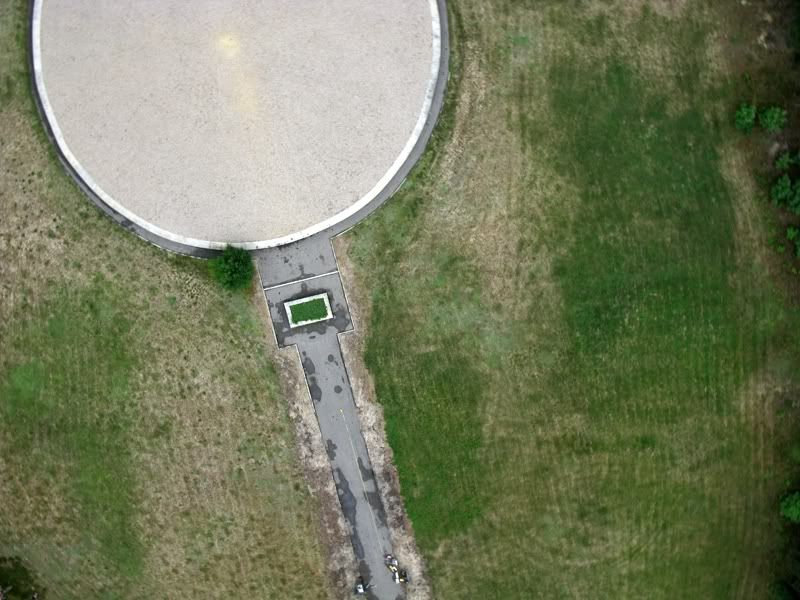
The areas around the mound which are greener than others are areas where mass graves of the Sobibor extermination camp are located. The grass grows greener over the graves, a phenomenon that can probably be explained by the fertilizing action of the human remains contained in the graves, which apparently act as a sort of dung. A similar phenomenon is reported in Lucja Nowak’s article about archaeological research at Chelmno, which I pointed out here:
The fifth grave
The last grave, or rather a line of pits filled with ashes, was not commemorated with any walls; in the 1960s it was already not discernible on the surface. On the basis of the description by Judge W. Bednarz it appears that in 1945 the pits were examined by him.
The total length of these pits equals 161 m. The stretch is made up of 11 pits, each located about 2-3 m from another. The dimensions of the pits vary from 9x7.5 m to 15.50x8.50 m. They are filled with gray soil with a significant mixture of burn waste and crushed human bones. In the southern (SE) part of the grave the bones found in the pits used to be ground; those in further parts - crushed. According to W. Bednarz, the depth of the pits was about 4 m, and the width 8-10 m. Even now the flora on the pits is more luxuriant, making this stretch more visible on the surface.[emphasis added]
In his post of Thu Sep 04, 2008 2:43 pm on the above-mentioned CODOH thread, the aptly named "Mr. Nobody" attempted an alternative explanation for the lush green patches amidst the sparsely vegetated soil:
All I see all over the site are Hundreds of years of Cultivation (Crop Sowing), Notice how deep the crop Furrows are, you wouldn't get this from a couple or years use (they wouldn't be discernible)
The Lush Green patches are indicative of well draining soil, nothing more, where as the lighter tan areas are TOTALLY consistent with the earth having been rammed or packed down to provide a firm base or "foundation" for the ROAD & MONUMENT, notice how this light tan area follows the outline of the aforementioned, the green patch next to the road could be the result of a natural drainage sump.
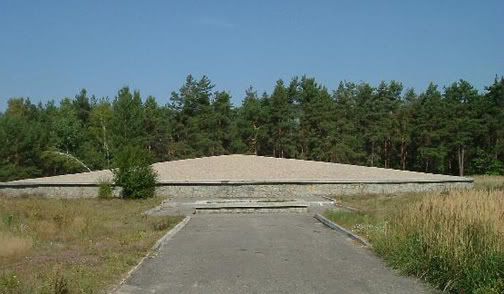
Crop land and crop furrows at Sobibor? I don’t know much about agriculture, but contemporary ground photos of the Sobibior area in general and the area around the monument in particular, like those from Michał Stępień’s collection and from archaeological research (the latter, incidentally, also include the core sample photos that are giving poor Gerdes many headaches) don’t look to me like land that was ever put to intensive agricultural use. They rather suggest a clearing in a wooded area, where vegetation is denser in the springtime and less so in the summer, which is when the air photo, as well as this photo by Alan Collins:
and this photo from the Sobibor Archaeological Project's website:

seem to have been taken.
According to the ARC page on Sobibor’s history,
The Sobibor area was swampy and is today as densely wooded as it was then.
The woody nature of the Sobibor area, as well as the sandy consistency of the soil there, are also addressed in my article “But wait”, the Ugly Voice’s fans will say ….
So there’s not much to suggest crop sowing at Sobibor, and thus no banana for "Mr. Nobody". Gerdes himself doesn’t seem convinced by his brother-in-spirit's theory, judging by what could be a conspiracy theory about manipulative dunging of the soil, in his CODOH post of Thu Sep 04, 2008 9:00 pm :
Yeah, I could have done better with a bag of Scotts Turf builder.
This is followed by a no less infantile straw-man:
Just imagine, every patch of green grass is "proof" that there are thousands of murdered jews buried below it.
and another of Gerdes statements of faith (or shall we say "lies"?):
But the funny thing is, not one pound of crushed bone has ever been located at Sobibor. And not one single tooth.
Whatever the appropriate designation is, considering the evidence referred to in, among others, my VNN post # 1094, Gerdes’ babbling gets us to the essential question of this article:
How do we know that the greener areas on the air photo contain mass graves?
We know it not just because they are greener, though my explanation for the lushly vegetated areas (human remains acting as fertilizer) is plausible whereas "Revisionist" attempts to provide a faith-conforming explanation are not. The key factor supporting this conclusion is another: the greener areas happen to coincide with the places where Prof. Kola identified mass graves in 2001, in the course of an archaeological investigation reported in the press at the time and referred to in my article More of the same trash … and in my VNN post # 777 (see exhibit IV.2.1, a Reuters press release about Prof. Kola’s findings ironically provided by Gerdes himself).
Though Prof. Kola has not yet published a detailed report about his findings at Sobibor in 2001, the essential results thereof seem to be known to other archaeologists. A map from Prof. Kola’s study, which shows mass graves areas coinciding with the lush green areas on the air photo, has been kindly provided to me by Yoram Haimi. As this map is not yet in the public domain, I have been advised not to publish it without Prof. Kola’s permission, so unfortunately I cannot show it yet in this article. In its place I show two recent maps of Sobibor including the circular monument partially visible on the air photo, in which the location and shape of the mass grave areas is similar to what is shown on Prof. Kola’s map.
One is the map made in 2002 by B. Rutherford and shown on this page:

The other is a map of the Sobibor memorial featured on the site of the Association "Friends of Sobibor Rememberance" (path: Masterplan > Camp Plan):

The clear areas in "Camp III" around the circular monument that is part of the memorial (drawn in bold red/violet lines) have the number 81, which corresponds to the designation "Burned victims’ ashes dump".
The shapes of these areas and their location in relation to the circular monument match the lush green areas on the air photo:
which are also matched by the location of the "groby" (Polish for "tombs", according to my online Polish translator) on the aforementioned map from Prof. Kola’s archaeological investigation in 2001.
Regarding ongoing trash on the CODOH thread My email to archeological 'expert' Yoram Haimi, see my VNN posts # 1147 and # 1151.
1st update
2nd update
3rd update
4th update
5th update
6th update
7th update
8th update
9th update
10th update
No comments:
Post a Comment
Please read our Comments Policy