The Auschwitz State Museum has published a 26-page booklet dedicated to Bunker 2 in Auschwitz-Birkenau (Bartosik & Martyniak, "Biały domek". Historia zagłady w bunkrze II, 2017). As already suggested by the front cover, the gassing facility known as Bunker 2 (in some accounts also Bunker 5) has been spotted on a photograph taken by the SS - AFAIK its only appearance in a contemporary ground photograph (Figure 1).
 |
| Figure 1: Construction site in Auschwitz-Birkenau, 1943 (Yad Vashem Archives, Photo Archives, Album FA157/344, Item 66393) |
The photograph in question originates from the album of the Zentralbauleitung (central construction office) Auschwitz. It is labelled as showing the construction of sewage oxygenation basins (between crematorium 3 and "Kanada", the section for storing and sorting the plundered effects of the deported Jews) at the Yad Vashem Photo Archives. However, according to "Biały domek" it was taken at the construction site of the so-called Zentralsauna, the main hygienic facility in the camp.
What follows is my take on the photograph and its interpretation in "Biały domek".
The skyline with two woods (the left one is farther away) corresponds indeed to what an observer from the sewage plant or Kanada/Zentralsauna complex looking west-northwest could see.
The photo was taken during the cold period with snow on the ground. According to documents in the publication The Architecture of Crime. The "Central Camp Sauna" in Auschwitz II-Birkenau, the construction work begun on 3 March 1943 and employed an excavator to dig the pit for the cellar in the main tract. The temperature was -5°C on this day.
The nearest tree to the left on the photograph looks similar to one close to the Zentrasauna looking in the direction of the Bunker 2 site on a photograph taken in 1962. I cannot assign all visible single trees to those on 1944 aerial photographs. However, it is possible that some had been chopped down between 1943-44.
Considering the above points, the photograph was possibly or even likely taken from construction site of the Zentralsauna looking towards the woods in the north-west, as suggested in the booklet "Biały domek" (Figure 2) (alternatively it was taken from further South at the sewage plant).
 |
| Figure 2: Illustration indicating the position and direction of view of the photographer according to Bartosik & Martyniak, "Biały domek". Historia zagłady w bunkrze II, p.8; note that the illuminated cone cannot correspond to the actual field of view, which extends to the woods on the right. |
 |
| Figure 3: Close-up of the white plastered house in Figure 1. |
Figure 3 depicts a close-up of the house shown on the photograph. It looks somewhat similar to other farmhouses in the area (Figure 4). There is also some similarity (but also differences) to a post-war drawing of Bunker 2 by the Jewish Sonderkommando prisoner David Olere (Figure 5). The house is apparently plastered in white, which is reported for Bunker 2 aka the "Little White House". Its position next to the woods and its orientation (looking approx. towards the edge of the house, with the long side to the left) corresponds to that of Bunker 2 on 1944 aerial photographs. On the other hand, its orientation does not correspond to the ruins of another house located some 20 m east of Bunker 2 (which apparently did not exist anymore at the time, though featured on a map of March 1943, because else it should appear to its right, see Figure 6).
Taking all these things together, the little white house on the photograph seems to be the infamous Bunker 2, which was employed by the SS in Auschwitz since summer 1942 to exterminate Jewish people.
There could be a security screen partly masking the entrance to the gas chambers on the long side of the building, but the else open and relatively close view from the Zentralsauna construction site and the fact that crematorium 2 was going into operation in March 1943, when I think the photograph was taken, suggests that the gassing facility was not in operation anymore.
 |
| Figure 4: Drawing of house no. 647, Budy (Van Pelt & Dwork, Auschwitz. Von 1270 bis heute, p. 337). |
 |
| Figure 5: David Olere, The Eyes of a Witness - A Painter in the Sonderkommando of Auschwitz, p.34 |
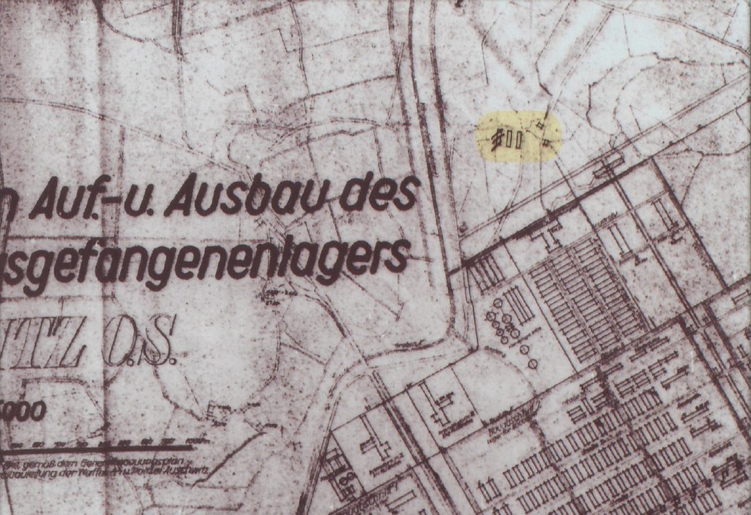 |
| Figure 6: Plan of Birkenau dated March 1943 document 15, Bartosik et al., The beginnings of the extermination of Jews in KL Auschwitz in the light of the source materials, p. 83 |
In addition to this ground photograph of 1943, Bunker 2 is shown on several aerial photographs shot between 31 May and 29 November 1944. The site was taken out of service after the crematoria took over the extermination just before or at the beginning of Spring 1943, but in May 1944 it was reactivated for the destruction of the Hungarian Jews to increase the killing and body disposal capacity of the camp.
Figure 7 compares the appearance of the Bunker 2 extermination site on 31 May and 25 August 1944. The area is mainly characterised by the gassing building (grey), two horse stables barracks (red), incineration sites (black), smaller barracks/barns (blue) and a thick security screen.
On 31 May 1944, the extermination area was still under construction and not completed yet. The horse stable barracks - for undressing and/or storing the clothing - have not been erected (the levelled ground for three barracks is visible as bright rectangles). The pentagon shaped area next to Bunker 2 is not completed and fully secured. To illustrate the incomplete nature of the site as of 31 May 1944, the perimeter as it later extends on 25 August 1944 is indicated with yellow lines. Some smoke is possibly rising from one of the incineration trenches indicating that the extermination site may have been already in operation (on this day about 9,000 Hungarian Jews arrived in Auschwitz-Birkenau and about 10,000 the day before).
 |
| Figure 7: Aerial photographs of Bunker 2 of 31 May and 25 August 1944. Markings as follows: gray = Bunker 2 building; black = incineration sites; red = location of horse stable barracks; blue = barn/barrack-like structures (storage and SS compound); yellow = site perimeter on 31 May 1944 photograph as it was on 25 August 1944. |
The next known aerial photograph of 26 June 1944 shows that two barracks were erected and the perimeter was extended and secured/camouflaged (as far as it is visible on the published photo, which only shows the eastern half of the extermination area).
The 23 and 25 August 1944 aerial photographs are of good quality and provide a more detailed look at the site (Figure 7 and 8). The full extension of the pentagon-shaped area with security and camouflage fence is obvious, several structures which could be small barracks/barns/guard stand - probably the storage and SS compound of the site -, three incineration trenches north-west of Bunker 2, several stripes between the horse stable barracks and the entrance to the gas chambers (perhaps some garden, like at the crematoria, or big benches for undressing?). Some spots along the security fence might be permanent guard posts, machine-gun nests, small bomb shelters (the Soviet investigators believed to have identified such along the south and south-west sides of the pentagon).
 |
| Figure 8: Aerial photographs of Bunker 2 of 31 May, 23 August, 25 August, 13 September, 29 November 1944 and 19 February 1945 (for sources of the photos see Auschwitz-Birkenau Aerial Photographs). |
Further aerial photographs of the area are compiled in Figure 8. On 13 September 1944, one of the incineration trenches was levelled indicating that Bunker 2 was about to get deactivated. On 29 November 1944, the body disposal sites are cleared, on 21 December 1944 the stable horse barracks are removed and the Bunker 2 building razed to the ground.
What is left on the aerial photograph of 19 February 1945, i.e. after Soviet liberation: a pit with an almost quadratic shape to the west of the former gas-chamber (also visible on prior aerial photographs) - perhaps serving as a water reservoir for fire fighting -, and a heap of wood/branches. The Soviet drawing illustrates the pile along the north-eastern side of the pentagon-shaped area found after the liberation of the camp. It was assumed to be "fuel wood for the cremation pit", but the aerial photos show that it was build up between 23 August 1944 and 29 November 1944, i.e. after the period of excessive deportations exceeding the capacity of the crematoria. It's conceivable that this is where remains of the dismantled security fence were dumped.
What do you think, Hans, did an unknown prisoner-artist depict Bunkers 1 and 2 in this piece?
ReplyDeletehttps://fcit.usf.edu/holocaust/RESOURCE/GALLERY/FWALL.HTM
https://www.historiography-project.com/books/pressac-auschwitz/543.php
Sometimes a barrack of the penal company is just that - a barrack of the penal company.
ReplyDeleteGreat analysis. Have any excavations been done at this site? This would provide really valuable additional information. Otherwise denies can claim it was just some farm house.
Delete