Part 1
Part 2
Part 3
Part 4
Part 5 (1)
Part 5 (2)
In this article I continue the presentation of administrative documents relating to mass graves from the extermination of the Jews in Lithuania in 1941, which like in the previous series will be contextualized with the 2nd Jäger Report and other evidence.
The documents presented hereafter are from districts of the GBK’s Panevėžys(Ponewesch), Šiauliai (Schaulen) and Vilnius(Wilna)-Land.
4. GBK Panevėžys(Ponewesch)
4.1 Panevėžys District
Document no.10: Letter dated 10 September 1942 from the District Medical Officer of the Panevėžys District to the Main Health Board (LCVA R627-1-150 fl. 43)[169]
This is a quite detailed report, which mentions mass graves at the following places:
1. Kupiškis community, within the limits of the Jewish grave-yard.
2. Panevėžys community:
a) Kurganava wood, 150-200 meters away from the Kurganava primary school - three graves 25x50 m;
b) Staniūnai-Keizerlingas wood, 0.5 km away from Velžis road - one 2.5x20 m grave;
c) Žaliasis wood, 2 km away from the Marčiuškos village, 300 meters away from the road to Stumbriškis - one grave, 2.5x25 m.
3. Subačius community, the Ilčiūnai wood, 0.75 km away from the Ilčiūnai primary school, about 50 m away from the field road from Ilčiūnai to the Subačiaus station and borough on the public road – Two graves, 2.5x8 m.
4. Šeduva community – in the Liaudiškiai wood, 1.5-2 km away from the Liaudiškiai village, 250 m from the road to Liaudiškiai – Paberžėlia - two graves, 3x4 m in one place, and one grave, 3x4 m, in another place.
The Kupiškis killings were not the work of the Rollkommando Hamann RKH. None of Hamann’s shooters was involved, in fact no Germans at all. In the second half of 1941, a Kupiškis self-defense unit shot about 1,000 people, largely communists and Soviet activists, in the Kupiškis Free Thinkers cemetery. [170] Throughout July and September, 1941, about 1,500–2,000 Jews from Kupiškis, Šimonys, Subačius and Viešintai rural districts were murdered. The shootings were carried out by the Kupiškis self-defense unit.[171]
EK3 was also not to blame for the murder of the Jews from Subačius, which was entirely the work of local white arm-banders[172] (aka "partisans").
The massacre of the Jews of Velžis was carried out by white arm-banders and "German soldiers" on 21 July 1941. [173] The "soldiers" were RKH killers. The massacre of 70 Jews and 33 non-Jews on that day was recorded under "Panevezys" in the 2nd Jäger Report. If the DMO’s measurements for the grave in the Staniūnai_Keizerlingas wood (2.5 x 20 = 50 m²) are correct, the grave space would have been used very generously (2 corpses per m²).
The massacre of the Jews of Šeduva community on 25-26 August 1941, at two sites as suggested by the DMO’s report (in the Liaudiškiai wood, two graves à 3x4 meters, and by the Liaudiškiai village, one grave, 3x4 meters), [174] seems to have been one of those occasions on which local forces (Šeduva policemen and white arm-banders) did the killing and Jäger claimed the credit for it. He recorded the killing of 230 Jews, 275 Jewesses and 159 Jewish children, 664 people in total, on this occasion. If the DMO’s estimate of the three graves’ measurements (3 x 4 = 12 m² each, 36 m²) is correct, the graves would probably have been deeper and the corpses would have been packed more densely in these graves than elsewhere in this district. [175]
In the Žaliasis wood the available grave space was also used economically, but less so than in the Liaudiškiai graves made for the Šeduva Jews. Two massacres took place in the Žaliasis wood, one on 4 August and another on 11 August 1941. [176] With the indispensable assistance of the Panevėžys 10th Police Battalion (20 of whose members even did or took part in the shooting proper during the second massacre), Hamann’s killers, according to the 2nd Jäger Report, ended the lives of 422 people (362 Jewish men, 41 Jewish women, 5 Russian communists, 14 Lithuanian communists) on the first and exactly 500 people (450 Jewish men, 48 Jewish women, and 2 communists) on the second occasion. If the DMO reported correctly in his letter of 10.9.1942, all these 922 corpses were buried in a single grave with the measurements 2.5 x 25 m (62.5 m²), which would thus have been used twice.[177]
The largest mass graves mentioned in the DMO’s letter, 3 graves with the measurements 25 x 50 meters each (1,250 m² per grave, 3,750 m² in total) were from the largest massacre committed in the Panevėžys district, which was also the largest massacre in which the RKH was involved and the second largest massacre on EK3’s record. Again with the indispensable assistance of the Panevėžys 10th Police Battalion, which brought the victims to the killing site and 70 of whose members took part in the shooting proper after their nerves had been steeled with vodka, Hamann’s shooters murdered 7,523 Jews (1,312 men, 4,602 women and 1,609 children) in a massacre recorded by Jäger under 23.8.1941, which may have lasted up to three days (24 to 26 August according to some sources). [178] With just 2 corpses per square meter of grave area, grave space economy was not necessary; in fact much of the grave space probably remained empty like in the grave shown on the drawing below. [179]

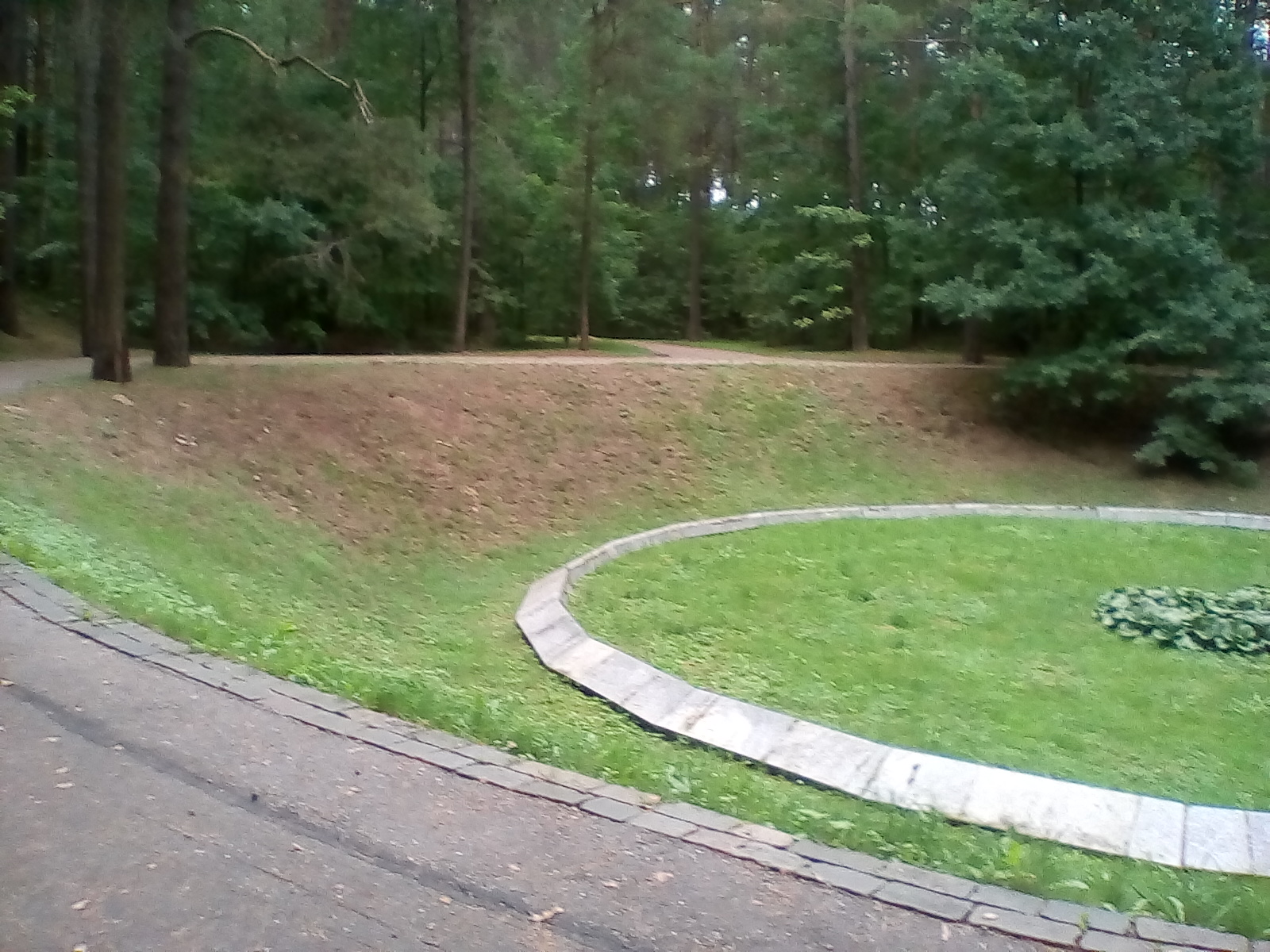
The killing site is referred to in various sources as either the Pajuostė forest[180] or the Kurganava woods. [181] The latter name seems to be linked to the nearby Kurganava Primary School (Kurganavos Pradžios Moklyos), mentioned in the DMO’s letter. The Kurganava Primary School (Kurganavos Pagrindine Mokyla) still exists; it is near road 3006 leading from a place called Kaminžkis (apparently a small hamlet) to a village called Trakiškis. There are fields and a large wooden area nearby. This seems to be the wood known as the Pajuostė forest, which the DMO called the Kurganava woods. It is not far away from the Kurganava Primary School, as can be seen on the images below. [182] The distance between the school and the current memorial is more than the 150-200 meters mentioned in the DMO’s letter. But then, the memorial, as can be seen in the photo below[183] covers only a very small part of the killing site, and the forest area may have become smaller in the decades since the massacre.


So much for the Panevėžys District of the GBK Panevėžys.
4.2 Ukmergė District
Document no.11: Letter dated 14 September 1942 from the District Medical Officer of the Ukmergė District to the Main Health Board (LCVA R627-1-150 fl. 64).[184]
In the Ukmergė District the RKH was involved in the killing of a total of 6,354 people, thereof 6,348 Jews, in four massacres recorded in the 2nd Jäger Report under the dates 1.8.1941 (296), 8.8.1941 (702), 19.8.1941 (641) and 5.9.1941 (4,709). The killing was done in the Pivonija forest[185], mentioned in the DMO’s letter. Like in other places assistance from local forces (especially that of white arm-banders from Žemaitkiemis, Vidiškiai and Kavarskas, led by K. Čiukšys) was essential. The Soviet Extraordinary Commission opened the mass graves in the Pivonija Forest at the end of August 1944. It estimated the number of victims at 12,000, which is too high.[186]
4.3 Utena District
Document no.12: Letter dated 15 September 1942 from the District Medical Officer of the Utena District to the Main Health Board (LCVA R627-1-150 fl. 66).[187]
A total of 4,609 people, thereof 4,603 Jews, were killed by RKH members and their local assistants, in 3 massacres recorded in the Jäger Report under the dates 31.7.1941 (251), 7.8.1941 (571) and 29.8.1941 (3,782). The last massacre is mentioned under "Utena und Moletai" in the 2nd. Jäger Report. Mass graves in Utena community and the Molėtai community, which are quite close to each other,[188] are mentioned in the DMO’s letter. In 1944 the Soviet commission investigating Nazi crimes found three big trenches and a few smaller ones in the Rašė forest. The commission estimated that about 9,000 people had been killed there. [189]
The other mass grave site in the Utena District mentioned by the DMO is at the Anykščiai community. Here the killing, which is not mentioned in the Jäger Report, was done exclusively by Lithuanian white arm-banders. [190]
4.3 Zarasai District
Document no.13: Letter dated 14 September 1942 from the District Medical Officer of the Zarasai District to the Main Health Board (LCVA R627-1-150 fl. 70).[191]
A single massacre in this district is mentioned in the Jäger Report, under the date 26.8.1941. A total of 2,567 Jewish men, women and children and two non-Jews were killed by members of the RKH and local white arm-banders. The place of the massacre mentioned in the Holocaust Atlas of Lithuania is the Degučiai administrative district, Dusetos forestry district, Krakynė forest.[192] According to the DMO’s letter the mass graves in the district were located as follows:
1. in the field of the Vencavai estate, the Antalieptė community;
2. Sųgardai estate in the Salakas community;
3. Steponiškiai village in the Antalieptė community.
Krakynė (Zarasai) is a village 3 km from Vencavai, a village near the road Dusetos-Degučiai. It’s only history seems to be that of the massacre on 26 August 1941. Krakynė lies in an open area that seems to be part of the Krakynės Miškas, the Krakynė forest. Another village in or close to that forest is Steponiškiai. The screenshots below show the Krakynės Miškas and each of the villages Krakynė, Vencavai and Steponiškiai.


5. GBK Šiauliai (Schaulen)
Šiauliai District
Document no.14: Letter dated 18 September 1942 from the District Medical Officer of the Šiauliai District to the Main Health Board (LCVA R627-1-150 fl. 51) [193]
The DMO’s letter mentions mass graves in the Normaičiai and Narutaičiai woods, as well as at Gruzdžiai and Žagarė. At the last of these towns 2,236 Jews (633 men, 1,107 women and 496 children) were killed on 2 October 1941 according to the 2nd Jäger Report. Žagarė merited a special mention because something extraordinary happened during this massacre: there was a revolt among the Jews being led to the killing site, whereupon 150 Jews were shot immediately, and 7 "partisans" were injured. The killing was commanded by three Germans, two lieutenants and one NCO, and the executors were the 14th Schutzmannschaft Battalion from Šiauliai, commanded by Lt. Kolokša, plus auxiliary police from Linkuva. [194] After the re-conquest of Lithuania, a Soviet commission examined the mass graves at Žagarė, opening three graves. From the first of these graves, shaped in the form of an "L", 80 meters long from north to west [south?], 42 meters from east to south [west?], 4 meters wide and 2 meters deep, 2,403 corpses were extracted, among them 530 men, 1,223 women and 625 children. [195]
6. GBK Vilnius (Wilna) Land
6.1 GBK Level
- Document no.15: Letter by the Regional Commissioner Wilna-Land to the Head Official of Nemenčinė dated 17.2.1942 (LCVA R-685-5-10-28). [196]
- Document no.16: Letter by the Regional Commissioner Wilna-Land, Horst Wulff, to the Heads of District, dated 25 April 1942 (LCVA R-685-5-10-41). [197]
- Document no.17: Letter by the Counselling Medical Officer of the Regional Commissariat Wilna-Land to the District Medical Officers, dated 16.06.1942 (LCVA R-613-1-10-71). [198]
In the first of these documents (no. 15) Regional Commissioner Horst Wulff reminded the Head Official (Amtsvorsteher) of Nemencing (Nemenčinė) that he should fence in the sites of Judenliquidationen, liquidations of Jews. Nemenčinė was one of EK3’s killing sites, where 403 Jews were killed by EK3’s Teilkommando in Wilna (TKW). The killing is recorded in the 2nd Jäger Report under 20.9.1941.
Nemenčinė was not Wulff’s only concern, as the second document (no. 16) shows. On 25 April 1942 he instructed the Švenčionys, Trakai, Vilna, Svyriai, Ašmena and Eišiškės distict heads to immediately pour chloride of lime in sufficient quantities on the sites of the liquidation of the Jews (Liquidierungsstätten der Juden) and fill up the sites with new soil. In four of these districts EK3 had conducted mass executions of Jews (Svyriai and Ašmena were only added to the Generalbezirk Litauen after EK3’s 1941 extermination campaign).
Public health concerns were also the reason behind the third document (no. 17). In this letter dated 16.6.1942 the Counselling Medical Officer of the Regional Commissariat Wilna-Land instructed the District Medical Officers of the GBK Wilna-Land to carry out an immediate control of all mass graves of Jews and prisoners of war in their respective districts as concerns their risk of epidemics, and to provide a precise description of the location of burial sites.
Three answers by District Medical Officers to this letter have been preserved and will be shown below.
6.2 Eišiškės District
Document no.18: Letter by the District Medical Officer of Eišiškės to the Regional Commissar’s Counselling Medical Officer, dated 08.08.1942 (LCVA R-613-1-10-64). [199]
Document no.19: Letter dated 10 September 1942 from the District Medical Officer of the Eišiškės District to the Main Health Board (LCVA R627-1-150 fl. 73).[200]
The first of these letters, handwritten in German with some linguistic errors as one would expect from a Lithuanian not fluent in the German language, was addressed to the Counselling Medical Officer of the Regional Commissariat Wilna-Land and thus in all probability a reply to the latter’s letter dated 16.6.1942 (Document no. 17), even though the date of that letter was mistakenly stated to be 10.6.1942. The Counselling Medical Officer’s letter dated 20.7.1942, also mentioned in the DMO’s reply, was probably a reminder after no answer to the first letter had been provided. The DMO’s letter mentions mass graves of Jews at two places in the Eišiškės District: 700 meters to the southeast of Eišiškės (city) dwelling homes, and 500 meters away from dwelling homes of the village Jursdika. Mass graves in the same places are also mentioned in the second document (no. 19).[201]
The massacre of the Jews from Eišiškės and surrounding towns, whose end result (3,446 Jewish men, women and children killed) is recorded in the 2nd Jäger Report under 27.9.1941, seems to have been committed with local assistance by a Lithuanian militia (also) known as the Ypatingasis Būris.[202] The killing was done at two places; Germans were also present but it is not clear whether they also took part in the shooting. [203]
6.3 Švenčionys District
Document no.20: Letter dated 14 September 1942 from the District Medical Officer of the Švenčionys District to the Main Health Board (LCVA R627-1-150 fl. 56). [204]
The letter mentions a mass graveyard at Švenčionėliai, the largest in the district, where about 5,000 people are buried. These people were Jews massacred on 7 and 8 October 1941 by a detachment of EK3, Ypatingasis Būris and about 120 local policemen and "partisans". The number of victims recorded in the 2nd Jäger Report under 9.10.1941 is 3,726. However, this number may be too low.[205]
The Švenčionys DMO’s letter is arguably the most significant document in the LCVA’s Main Health Board collection presented in this series, as it is the only one mentioning the number of people (about 5,000) who, according to its author’s estimate and/or information he had available, were buried at one of EK3’s killing sites. The number is in line with at least one other estimate and, if correct, would mean that Jäger undercounted the victims of this massacre and the DMO was better informed about the number killed than Jäger. The DMO’s letter doesn’t mention that the people buried in the mass graveyard at Švenčionėliai were Jews, but there’s no evidence to suggest any other possibility.
6.4 Trakai District
Document no.21: Letter dated 31 August 1941 by the Head of Trakai District to the Regional Commissioner Wilna-Land (LCVA R-500-1-4t.1-250). [206]
Document no.22: Letter by the Chief of Kaišiadorys Police Station to Trakai Head of District dated 1 September 1941 (LCVA R-500-1-4t.1-258).[207]
Document no.23: Letter by the Head of Trakai District, dated 8 November 1941, Trakai town mayor, Žiežmariai, Semeliškės and Eišiškės community provosts (LCVA R-500-1-4llt-794). [208]
Under the date 26.8.1941, the 2nd Jäger Report recorded the murder of the entire Jewish population of Kaišiadorys, 1,911 men, women and children. Either Jäger got the date wrong or the massacre lasted until 27 August, for the Kaišiadorys Precint Chief of the Trakai District Police, in a letter dated 1 September 1941, informed the Head of Trakai District that on 27 August all Jews of Kaišiadorys had been shot by "Kaunas Auxiliary Police" and "German soldiers" (Document no. 22). As usual, local forces took part in the killing – Kaišiadorys white arm-banders, police and local volunteers. According to the Holocaust Atlas of Lithuania, the massacre took place at several sites, one in the so-called Vasiliev ditch, and the other next to what is now the Vilnius–Kaunas highway. The victims also included Jews from the surroundings of Kaišiadorys, which had previously been brought to Kaišiadorys: 263 men and 85 women from Žasliai, 193 men and 85 women from Žiežmariai. [209]
A few days later it was the turn of the remaining Jews of Žasliai and Žiežmariai and those of Rumšiskės. The killing of 784 Jews (20 men, 567 women and 197 children) was recorded in the 2nd Jäger Report under the date 29.8.1941 and the place names Rumsiskis u. Ziezmariai (Rumšiškės and Žiežmariai).
In his aforementioned letter to the Head of Trakai District, the Kaišiadorys Precint Chief apparently was not breaking any news. On the date before that of the precint chief’s letter, 31 August 1941, the Head of District had already sent a letter to the Regional Commissioner in Vilnius, informing that in Kaišiadorys, Žasliai and Žiežmariai there was not a single Jew left and requesting instructions on how the mobile and immobile property of the murdered Jews was to be disposed of (Document no. 21).
The Head of Trakai District also produced the first surviving document that I know of suggesting public health concerns in connection with the mass graves of murdered Jews. In his letter dated 8.11.1941 (Document no. 23) he instructed the mayor of Trakai and the provosts of the Žiežmariai, Semeliškės and Eišiškės communities[210] to fence in the "Jewish graves" so that animals and people could not access them, and to pour chloride of lime on the graves on the 25th of each month if the ground was not frozen.
Document no.24 Letter dated 8 July 1942 by the District Medical Officer of Trakai District to the Regional Commissioner Wilna-Land (LCVA R 613/1/10 fl. 69+69a).[211]
Responding on 8.7.1942 to the letter sent on 16.6.1942 by the Counselling Medical Officer of the Regional Commissariat Wilna-Land (Document no. 17), the District Medical Officer of the Trakai District mentioned the following mass graves:
The first two mass graves can be clearly attributed to two massacres recorded in the 2nd Jäger Report: Trakai, 30.9.1941, (1,446 Jewish men, women and children) and Semiliski (Semeliškės), 6.10.1941 (962 Jewish men, women and children). These massacres were organized by EK3’s Teilkommando in Wilna (TKW), which started its killing activity on 12 August 1941 and until 17.9.1941 murdered Jews in the city of Vilnius only, before also visiting communities of the Vilnius and Trakai districts. The aforementioned earlier massacres (recorded under 26 and 29 August) in communities of the Trakai District close to the Kaunas District (Kaišiadorys, Rumšiškės and Žiežmariai) were the work of the RKH, operating from Kaunas city, and its local assistants. The territorial competences of these two sub-units of EK3 are probably the reason, or one of the reasons, why massacres at places that were relatively close together were carried out in different periods, some in late August and others in September/October 1941.
The mass grave at Trakai, according to the DMO’s letter, was 80 meters long, 4 meters wide and 4 meters deep, i.e. it had a volume of 1,280 m³. Even deducting 80x4x1.5 = 480 m³ for the soil cover, the mass grave would still be over-dimensioned for the corpses of "only" 1,446 people, especially as many of these were children. [212] This suggests that, if the DMO’s measurements were correct, the pit was originally meant for a number of victims significantly higher than those eventually buried there, and that the grave eventually remained empty in some parts like in the figure shown earlier in this article. As a grave with the measurements 30 x 4 x 4 meters would have been perfectly sufficient, [213] and as the length of the other graves in the area mentioned by the DMO is in that order, it is also possible that the "80" resulted from a typo and was meant to read "30". In the 30 meter long mass grave at Semeliškės, assuming that it had the same width and depth as the one at Trakai, use of available grave space would have been fairly economical, though with much room for improvement. [214]
As to the other to mass graves mentioned in the DMO’s report, the closest association is that of the killing of the Jews of Kaišiadorys, Rumšiškės and Žiežmariai, recorded in the 2nd Jäger Report under the dates 26 and 29 August 1941. Assuming a depth and width of respectively 4 meters for the graves mentioned under items 3, 1) and 3, 2) of the DMO’s report, the volume of these graves would be more than sufficient to take in the corpses of the 2,695 victims of these massacres, if all these victims had been buried there (see below).
The reference of the first grave site is 3 km north from Žiežmariai, 1 km from the road between Žiežmariai and Žasliai. The distance between these two locations by car is 16.4 km along the fastest route, via the Žaslių gatvė (road 1808), which runs west/northwest of the Strošiūnų kraštovaizdžio draustinis (Stošiūnai Landscape Reserve) and passes by Triliškės village. The location is shown on the screenshots below from the Holocaust Atlas of Lithuania and from Google Maps.[215]The Triliškės village is 8.1 road kilometers by car away from Kaišiadorys by the shortest route. [216]The distance between Kaišiadorys and the killing site as the crow flies would be much shorter. So the site would be quite suitable for killing the Jews collected at Kaišiadorys and Žiežmariai.


The reference of the second grave site is 5 km from Zesmaren, 2 km from the road Kaischedoren-Zesmaren, by the Bladukischker Forest. Unlike the first site, this one is not shown in the Holocaust Atlas of Lithuania, which places the second killing site of Kaišiadorys and Žiežmariai Jews near a village called Strošiūnai next to what is now the Vilnius–Kaunas highway. [217] It seems that there is no forest currently called Bladukiškės miškas (Bladukishkes Forest); the closest match on the map[218] is a wooded area to the southwest of Vladikiškės, on the other side of the Kauno gatvė (road 142/1806). The wood may have been larger in 1941 than it is now. Vladikiškės is mentioned as one of the Kaišiadorys/Žiežmariai killing sites in other sources. [219] This would mean that a mass grave mentioned by the Trakai DMO didn’t enter the Lithuanian record of killing sites while on the other hand a killing site that has a Lithuanian Unique Object Code[220] was not mentioned by the Trakai DMO in 1942, for whatever reason.


Also not mentioned in the DMO’s letter is the shooting of the last 80 Jews of Rumšiškės on the outskirts of the Pieveliai village, which took place on the same date as the massacre of the remaining Jews of Žiežmariai and Žasliai, 29 August 1941. [221] However, this omission is easy to explain. Whereas Žiežmariai was located in the Trakai District of the GBK Wilna-Land, Rumšiškės was located in the Kaunas District of the GBK Kaunas-Land, thus outside the Trakai DMO’s area of competence.
6.5 Vilnius District
Besides the aforementioned correspondence from the Regional Comissioner of the GBK Wilna Land (documents nos. 15 and 16) and his Counselling Medical Officer (document no. 17), the surviving documentation includes another response to the Counselling Medical Officer’s letter dated 16.6.1942.
Document no.25: Letter sent by the District Medical Officer of Wilna(Vilnius) District to the Regional Commissioner of Wilna Land on 30.7.1942 (LCVA R613/1/10, fl. 70+70a). [222]The DMO mentioned the following mass grave sites:
1) In the community Nemenčinė, in the forest Vienuolynas, 3 km away from Nemenčinė;
2) In the community Mickūnai, in the small forest of the Viličionis estate;
3) In the community of Rieše, at the edge of the forest Naujaneriai;
4) In the community Jašiunai, in the small forest of the Jašiunai estate.
5) In the community Rudamina, in the small forest Paneriai (near the Paneriai railway station).
Mass grave site no. 5 is the Ponary/Paneriai killing site, the largest in Nazi-occupied Lithuania, where at the time of the DMO’s letter about 28,000 people, overwhelmingly Jews, had been buried.[223] The circular pits mentioned by the DMO are now part of the Paneriai memorial. They are of course covered up, except for the upper parts, which are sloped like the walls of a crater. During a brief tour of Paneriai last 14 August I took the photos shown below.


Now to the other four mass grave sites mentioned by the Wilna District’s DMO.
According to the 2nd Jäger Report, 403 Jews were shot on 20.9.1941 at Nemenčinė, and 1,767 were shot at Rieše on 24.9.1941. Strangely the mass grave described by the DMO in the forest Vienuolynas, 3 km away from Nemenčinė (50 x 30 m large), would be grossly overdimensioned for only 403 corpses,[224] whereas the mass grave in the community of Rieše, at the edge of the forest Naujaneriai, measures only 25 x 4 m according to the DMO’s letter, [225] and would thus be much smaller not only than the one near Nemenčinė but also than the grave at Mickūnai (50 x 12 m) and the one at Jašiunai, in the small forest of the Jašiunai estate (30 x 10 m). This suggests that the "4" regarding the Rieše grave should read "40", bringing this grave more in line with the others, or that the DMO mixed up the Nemenčinė and Rieše areas in his letter as concerns the size of the mass graves. It is also possible, considering that Nemenčinė and Naujaneriai are just 13.9 car kilometers away from each other, [226] that a significant part of the Jews recorded by Jäger under Rieše are buried (or were originally meant to be buried) at a larger mass grave near Nemenčinė. The Jews of Nemenčinė were marched 3 kilometers into the forest in the direction of Vilnius, [227] whereas the Naujaneriai village, where the Jews of Rieše and other locations (Maišiagala, Paberžė, etc.) are thought to have been killed, is 7 km away from Rieše. [228] So the two killing sites must have been rather close together.
The mass grave at Mickūnai mentioned in the same letter probably corresponds to the massacre at Novo-Wilejka mentioned in the 2nd Jäger Report under 22.9.1941 (1,159 Jews, thereof 468 men, 495 women and 196 children). Mickūnai is just 7.5 km by car from Naujoji Vilnia (=Novo-Wilejka). [229] In fact, the site of the mass grave mentioned by the DMO (small forest of the Viličionis estate) coincides with the place where, according to other evidence, the Jews of Naujoji Vilnia were murdered. [230]
The mass grave at Jašiunai, in the small forest of the Jašiunai estate, clearly corresponds to the massacre of 575 Jews recorded under 25.9.1941 in the 2nd Jäger Report.[231] Again, the mass grave described by the DMO (30 x 10 meters = 300 m²) seems overdimensioned, though not as grossly as the one at Nemenčinė would be if it contained only 403 Jews.[232]
Besides the mass graves from the massacres of the Jewish population in the district for which he was responsible, the Vilnius DMO also mentioned mass graves at the "N. Wilna" (=Naujoji Vilnia) camp for Soviet PoWs, about which he had not been able to obtain information as the graves were wholly on territory controlled by the Wehrmacht. The Soviet Extraordinary Commission estimated that about 13,000 PoWs perished at this camp. [233] In another PoW camp in the Vilnius area, at Bezdonys, up to 25,000 PoWs died and were buried in 18 mass graves. [234] For some reason the Bezdonys camp isn’t mentioned in the DMO’s report. But like in other cases addressed in this article, the non-mention of a mass graves site in a report about sanitation matters does not mean that such site didn’t exist. The mention of such site, on the other hand, corroborates evidence which, like the 2nd Jäger Report, refers to mass killings in the corresponding location.
Facsimiles of the documents mentioned in this article are shown hereafter.
Following these documents is a color copy of the Jäger Report, reproduced with the kind permission of Gilles Karmasyn, who first published published this color copy on the PHDN site.
Document no. 10 (LCVA R627-1-150 fl. 43)

Document no. 11 (LCVA R627-1-150 fl. 64)

Document no. 12 (LCVA R627-1-150 fl. 66)

Document no. 13 (LCVA R627-1-150 fl. 70)

Document no. 14 (LCVA R627-1-150 fl. 51)

Document no. 15 (LCVA R-685-5-10-28).

Document no. 16 (LCVA R-685-5-10-41)

Document no. 17 (LCVA R-613-1-10-71)

Document no. 18 (LCVA R-613-1-10-64)

Document no. 19 (LCVA R627-1-150 fl. 73)

Document no. 20 (LCVA R627-1-150 fl. 56)

Document no.21 (LCVA R-500-1-4t.1-250)

Document no.22 (LCVA R-500-1-4t.1-258)

Document no.23 (LCVA R-500-1-4llt-794)

Document no.24 (LCVA R 613/1/10 fl. 69+69a)


Document no.25 (LCVA R613/1/10, fl. 70+70a)


---
Below is the aforementioned color copy of the Jäger Report, as featured on this page. Source: Russian Military State Archives in Moscow (Rossiiskii Gosudarstvennyi Voennyi Arkhiv / Российский государственный военный архив) abbreviated RGVA, aka State Archives Moscow, file 500-1-25, fls. 110 to 118. The remark at the top of the page reads as follows:


Notes
[169] Fascimile and translation.
[170] Holocaust Atlas of Lithuania, first entry for Kupiškis
[171] Holocaust Atlas of Lithuania, second entry for Kupiškis .
[172] Holocaust Atlas of Lithuania, third entry for Kupiškis. The entry mentions 80 victims, which considering the measurements of graves described by the DMO (2 graves à 2.5x8 = 20 m², 40 m² in total) means that either grave space was used very generously (2 corpses per square meter), or something bigger happened here (possibly some of the Jews from from Kupiškis, Šimonys, Subačius and Viešintai, mentioned in the second entry, were buried in these graves as well).
[173] Holocaust Atlas of Lithuania, fourth entry for Panevėžys.
[174] Holocaust Atlas of Lithuania, first and second entry for Šeduva.
[175] The burial density would have been about 6 per m³ if the graves were 3 meters deep, 9 per m³ if the depth was 2 meters. Regarding the burial density that can be achieved if there are many children among the corpses and grave space is used economically, see my article "Alleged" Mass Graves and other Mattogno Fantasies (Part 4, Section 1).
[176] Holocaust Atlas of Lithuania, second entry for Panevėžys. The Atlas mistakenly counts only the male Jews (362) of the first massacre recorded in the 2nd Jäger Report.
[177] Assuming a grave depth of 3 meters, the burial density would have been about 5 corpses per cubic meter.
[178] See notes 84 and 85.
[179] The drawing is from R. Wright, I. Hanson and J. Sterenberg, "The Archaeology of Mass Graves", in: John Hunter and Margaret Cox, Forensic Archaeology: Advances in Theory and Practice, 2005 Routledge, London and New York, pp. 137-158 (p. 148).
[180] E.g. the Holocaust Atlas of Lithuania, third entry for Panevėžys . Precise location: Panevėžys district, Miežiškiai administrative district, Biliūnai village, Pajuostė forest.
[181] E.g. "Lithuania's biggest cities to pay tribute to Holocaust victims", Delfi by The Lithuania Tribune, January 26, 2018; "Remembering the Holocaust in Panevėžys", The Jewish Community of Lithuania, 25.09.2016; Panevėžio krašto žydų istorija - Panevėžio miesto žydų bendruomenė (article on the website of the Panevėžys Jewish Community).
[182] The first two images are from Google Maps, here and here. The third image is based on the map of the Pajuostė forest killing site on the page Gedenkorte Europas 1939-1945 - Panevėžys Stadt.
[183] The photo is from the same page mentioned in the previous note.
[184] Facsimile and translation.
[185] Holocaust Atlas of Lithuania, fourth entry for Ukmergė.
[186] Dieckmann, Besatzungspolitik, p. 368, citing Act of the Commission in GARF (Государственный архив Российской Федерации – ГАРФ, the State Archive of the Russian Federation), 7021-94-432, fl. 1f.
[187] Facsimile and translation.
[188] Shortest distance by car is 36.7 km according to Google Maps.
[189] Holocaust Atlas of Lithuania, second entry for Utena.
[190] Holocaust Atlas of Lithuania, Mass Killing of the Jews of Anykščiai.
[191] Facsimile and translation.
[192] Holocaust Atlas of Lithuania, Mass Killing of the Jews from the Zarasai Area.
[193] Facsimile and translation.
[194] Dieckmann, Besatzungspolitik, pp. 843-847 (p. 846).
[195] Act on Crimes of Fascist Aggressors and their Accomplices in the Vicinity of the City of Žagarė, October 5, 1944, reproduced in Tragedy, Document 16, pp. 58-60. The geographic directions may be mixed up in the English translation.
[196] Facsimile, transcription and translation.
[197] Facsimile, transcription and translation.
[198] Facsimile, transcription and translation.
[199] Facsimile, transcription and translation.
[200] Facsimile and translation.
[201] The former letter, apparently signed by the same person as the latter, mentions a soil cover of 0.5-1m, whereas in the latter it is stated that in May of that year an additional soil layer of 1.5 meters had been put on the graves close to Eišiškės, that the graves close to the Jursdika village had been arranged so that the soil cover was no less than 1.5 meters deep, and that the graves had been fenced. It cannot be established why the DMO provided different information as concerns the (additional) soil layer to the Counselling Medical Officer on the one hand and the Main Health Board on the other, and why the fencing is mentioned in the latter but not in the former letter. It is possible that the soil covering to a depth of 1.5 meters and the fencing had been done following instructions received after the first letter and the DMO had an interest in claiming earlier accomplishment. Another possibility is that when writing the latter letter the DMO had more accurate information as concerns the measures taken than when writing the former. Anyway, the graves mentioned in one and the other letter are obviously the same.
[202] Dieckmann, Besatzungspolitik.The members of this unit were recruited in Vilnius by Martin Weiss from the Lietuvos Šaulių Sajunga organization, popularly known as Shaulists. The group was commanded by Juzoas Šidlauskas, and then Balys Norvaiš, both former officers of the Lithuanian army, subordinated to the Germans. The unit started out with 50 volunteers in July 1941 and soon grew to several hundred soldiers and officers. It almost entirely consisted of Lithuanian activists, although it also included three Poles and a few Russians. Commands were issued in Lithuanian, and the unit was called Ypatingasis Burys (full name Vokieciu Saugumo policijos ir SD ypatingasis burys – The Special Branch of the Security Police and SD). Among the Polish population of Vilnius they were usually known as the "Ponary riflemen". See Piotr Niwiński, Ponary. The Place of "Human Slaughter" (brochure in Polish, Lithuanian and English), p. 16.
[203] Holocaust Atlas of Lithuania, Mass Murder of the Jews at Eišiškės; Mass Murder of the (Elderly) Jews of Eišiškės.
[204] Facsimile and translation.
[205] Dieckmann, Besatzungspolitik, pp. 908-910. Dieckmann considers a number of victims in the order of 5,000 more probable.
[206] Facsimile, transcription and translation.
[207] Facsimile, transcription and translation.
[208] Facsimile, transcription and translation .
[209] Holocaust Atlas of Lithuania, Mass Murder of the Jews of Kaišiadorys and Surrounding Areas; Dieckmann, Besatzungspolitik, p. 899.
[210] At the time when this letter was written, the Eišiškės community was part of the Trakai District of the GBK Wilna-Land. The Eišiškės District, comprising this area and areas that had been part of the Generalbezirk Weißruthenien, was formed as of 1.4.1942. See note 8.
[211] Facsimile, transcription and translation.
[212] The concentration would be just about 2 corpses per cubic meter, well below the concentration (at least about 11 corpses per cubic meter, see my article "Alleged" Mass Graves and other Mattogno Fantasies (Part 4, Section 1)) that would be feasible if the available space were used as sparingly as possible.
[213] The volume would 480 m³, 300 m³ after deducting the assumed soil cover (180 m³). 1,446 corpses in 300 m³ would be about 5 corpses per cubic meter.
[214] 962 corpses in 300 m³ = about 3 corpses per cubic meter.
[215] Žasliai to Žiežmariai.
[216] Kaišiadorys to Triliškės.
[217] See the Holocaust Atlas of Lithuania pages Mass Murder of the Jews of Kaišiadorys and Surrounding Areas and Mass Murder of the Jews (Women, Children and Elderly) of Kaišiadorys and Surrounding Areas.
[218] Žiežmariai to Kaišiadorys
[219] Diekmann, Besatzungspolitik, p. 899; Bubnys, Province, p. 55. Bubnys cites the interrogation of one A. Dvilevičius of 30 October 1952.
[220] The Unique Object Code (Unikalus objekto koda) is 10891 - Žydų žudynių vieta ir kapas - Kaišiadorių rajono sav., Žiežmarių apylinkės sen., Bačkonių k., while that of the killing site near Triliškės is 10892 - Žydų žudynių vieta ir kapas - Kaišiadorių rajono sav., Žiežmarių apylinkės sen., Triliškių k.
[221] Holocaust Atlas of Lithuania, Mass Murder of the Jews of Rumšiškės. Bubnys (Province, p. 57) considers the number 784, stated for Rumšiškės and Žiežmariai in the 2nd Jäger Report under 29 August 1941, to be too high if including only the remaining Jews from these two places. He assumes that the figure also includes Jews from other locations killed on the same day.
[222] Facsimile, transcription, translation.
[223] See my article How many people were killed at Ponary.
[224] The mass grave (50m x 30 m = 1,500 m²) would be generously dimensioned even for 1,767 corpses, and that even assuming a depth of only meter below a soil layer 2 meters thick. With only 403 corpses, the concentration would be one corpse per 3 or 4 cubic meters. Most of the grave would thus have remained empty.
[225] Assuming a depth of two meters below the soil layer, 25x4x2 = 200 m² would have been available for burying about 1,800 corpses – feasible, but unnecessary considering that larger graves could obviously be dug quite easily in soil of similar consistency at similar places.
[226] According to Google Maps, Nemenčinė to Naujaneriai.
[227] Holocaust Atlas of Lithuania, Mass murder of the Jews from Nemenčinė .
[228] Holocaust Atlas of Lithuania, Mass murder of the Jews at Naujaneriai .
[229] According to Google Maps.
[230] Holocaust Atlas of Lithuania, Mass murder of the Jews in Vėliučionys; Dieckmann, Besatzungspolitik, p. 895.
[231] The only mass killing of Jews in this area mentioned in the Holocaust Atlas of Lithuania is the Mass murder of the Jews of Jašiunai.
[232] The area of the grave was 30x10 = 300 m². Assuming a depth of 1 meter below the 2 meters of soil layer, the concentration would still be less than 2 corpses per cubic meter.
[233] Dieckmann, Besatzungspolitik, p. 1357.
[234] Gedenkorte Europas 1939-1945, Bezdonys; Dieckmann, as above.
Part 2
Part 3
Part 4
Part 5 (1)
Part 5 (2)
In this article I continue the presentation of administrative documents relating to mass graves from the extermination of the Jews in Lithuania in 1941, which like in the previous series will be contextualized with the 2nd Jäger Report and other evidence.
The documents presented hereafter are from districts of the GBK’s Panevėžys(Ponewesch), Šiauliai (Schaulen) and Vilnius(Wilna)-Land.
4. GBK Panevėžys(Ponewesch)
4.1 Panevėžys District
Document no.10: Letter dated 10 September 1942 from the District Medical Officer of the Panevėžys District to the Main Health Board (LCVA R627-1-150 fl. 43)[169]
This is a quite detailed report, which mentions mass graves at the following places:
1. Kupiškis community, within the limits of the Jewish grave-yard.
2. Panevėžys community:
a) Kurganava wood, 150-200 meters away from the Kurganava primary school - three graves 25x50 m;
b) Staniūnai-Keizerlingas wood, 0.5 km away from Velžis road - one 2.5x20 m grave;
c) Žaliasis wood, 2 km away from the Marčiuškos village, 300 meters away from the road to Stumbriškis - one grave, 2.5x25 m.
3. Subačius community, the Ilčiūnai wood, 0.75 km away from the Ilčiūnai primary school, about 50 m away from the field road from Ilčiūnai to the Subačiaus station and borough on the public road – Two graves, 2.5x8 m.
4. Šeduva community – in the Liaudiškiai wood, 1.5-2 km away from the Liaudiškiai village, 250 m from the road to Liaudiškiai – Paberžėlia - two graves, 3x4 m in one place, and one grave, 3x4 m, in another place.
The Kupiškis killings were not the work of the Rollkommando Hamann RKH. None of Hamann’s shooters was involved, in fact no Germans at all. In the second half of 1941, a Kupiškis self-defense unit shot about 1,000 people, largely communists and Soviet activists, in the Kupiškis Free Thinkers cemetery. [170] Throughout July and September, 1941, about 1,500–2,000 Jews from Kupiškis, Šimonys, Subačius and Viešintai rural districts were murdered. The shootings were carried out by the Kupiškis self-defense unit.[171]
EK3 was also not to blame for the murder of the Jews from Subačius, which was entirely the work of local white arm-banders[172] (aka "partisans").
The massacre of the Jews of Velžis was carried out by white arm-banders and "German soldiers" on 21 July 1941. [173] The "soldiers" were RKH killers. The massacre of 70 Jews and 33 non-Jews on that day was recorded under "Panevezys" in the 2nd Jäger Report. If the DMO’s measurements for the grave in the Staniūnai_Keizerlingas wood (2.5 x 20 = 50 m²) are correct, the grave space would have been used very generously (2 corpses per m²).
The massacre of the Jews of Šeduva community on 25-26 August 1941, at two sites as suggested by the DMO’s report (in the Liaudiškiai wood, two graves à 3x4 meters, and by the Liaudiškiai village, one grave, 3x4 meters), [174] seems to have been one of those occasions on which local forces (Šeduva policemen and white arm-banders) did the killing and Jäger claimed the credit for it. He recorded the killing of 230 Jews, 275 Jewesses and 159 Jewish children, 664 people in total, on this occasion. If the DMO’s estimate of the three graves’ measurements (3 x 4 = 12 m² each, 36 m²) is correct, the graves would probably have been deeper and the corpses would have been packed more densely in these graves than elsewhere in this district. [175]
In the Žaliasis wood the available grave space was also used economically, but less so than in the Liaudiškiai graves made for the Šeduva Jews. Two massacres took place in the Žaliasis wood, one on 4 August and another on 11 August 1941. [176] With the indispensable assistance of the Panevėžys 10th Police Battalion (20 of whose members even did or took part in the shooting proper during the second massacre), Hamann’s killers, according to the 2nd Jäger Report, ended the lives of 422 people (362 Jewish men, 41 Jewish women, 5 Russian communists, 14 Lithuanian communists) on the first and exactly 500 people (450 Jewish men, 48 Jewish women, and 2 communists) on the second occasion. If the DMO reported correctly in his letter of 10.9.1942, all these 922 corpses were buried in a single grave with the measurements 2.5 x 25 m (62.5 m²), which would thus have been used twice.[177]
The largest mass graves mentioned in the DMO’s letter, 3 graves with the measurements 25 x 50 meters each (1,250 m² per grave, 3,750 m² in total) were from the largest massacre committed in the Panevėžys district, which was also the largest massacre in which the RKH was involved and the second largest massacre on EK3’s record. Again with the indispensable assistance of the Panevėžys 10th Police Battalion, which brought the victims to the killing site and 70 of whose members took part in the shooting proper after their nerves had been steeled with vodka, Hamann’s shooters murdered 7,523 Jews (1,312 men, 4,602 women and 1,609 children) in a massacre recorded by Jäger under 23.8.1941, which may have lasted up to three days (24 to 26 August according to some sources). [178] With just 2 corpses per square meter of grave area, grave space economy was not necessary; in fact much of the grave space probably remained empty like in the grave shown on the drawing below. [179]

The killing site is referred to in various sources as either the Pajuostė forest[180] or the Kurganava woods. [181] The latter name seems to be linked to the nearby Kurganava Primary School (Kurganavos Pradžios Moklyos), mentioned in the DMO’s letter. The Kurganava Primary School (Kurganavos Pagrindine Mokyla) still exists; it is near road 3006 leading from a place called Kaminžkis (apparently a small hamlet) to a village called Trakiškis. There are fields and a large wooden area nearby. This seems to be the wood known as the Pajuostė forest, which the DMO called the Kurganava woods. It is not far away from the Kurganava Primary School, as can be seen on the images below. [182] The distance between the school and the current memorial is more than the 150-200 meters mentioned in the DMO’s letter. But then, the memorial, as can be seen in the photo below[183] covers only a very small part of the killing site, and the forest area may have become smaller in the decades since the massacre.


So much for the Panevėžys District of the GBK Panevėžys.
4.2 Ukmergė District
Document no.11: Letter dated 14 September 1942 from the District Medical Officer of the Ukmergė District to the Main Health Board (LCVA R627-1-150 fl. 64).[184]
In the Ukmergė District the RKH was involved in the killing of a total of 6,354 people, thereof 6,348 Jews, in four massacres recorded in the 2nd Jäger Report under the dates 1.8.1941 (296), 8.8.1941 (702), 19.8.1941 (641) and 5.9.1941 (4,709). The killing was done in the Pivonija forest[185], mentioned in the DMO’s letter. Like in other places assistance from local forces (especially that of white arm-banders from Žemaitkiemis, Vidiškiai and Kavarskas, led by K. Čiukšys) was essential. The Soviet Extraordinary Commission opened the mass graves in the Pivonija Forest at the end of August 1944. It estimated the number of victims at 12,000, which is too high.[186]
4.3 Utena District
Document no.12: Letter dated 15 September 1942 from the District Medical Officer of the Utena District to the Main Health Board (LCVA R627-1-150 fl. 66).[187]
A total of 4,609 people, thereof 4,603 Jews, were killed by RKH members and their local assistants, in 3 massacres recorded in the Jäger Report under the dates 31.7.1941 (251), 7.8.1941 (571) and 29.8.1941 (3,782). The last massacre is mentioned under "Utena und Moletai" in the 2nd. Jäger Report. Mass graves in Utena community and the Molėtai community, which are quite close to each other,[188] are mentioned in the DMO’s letter. In 1944 the Soviet commission investigating Nazi crimes found three big trenches and a few smaller ones in the Rašė forest. The commission estimated that about 9,000 people had been killed there. [189]
The other mass grave site in the Utena District mentioned by the DMO is at the Anykščiai community. Here the killing, which is not mentioned in the Jäger Report, was done exclusively by Lithuanian white arm-banders. [190]
4.3 Zarasai District
Document no.13: Letter dated 14 September 1942 from the District Medical Officer of the Zarasai District to the Main Health Board (LCVA R627-1-150 fl. 70).[191]
A single massacre in this district is mentioned in the Jäger Report, under the date 26.8.1941. A total of 2,567 Jewish men, women and children and two non-Jews were killed by members of the RKH and local white arm-banders. The place of the massacre mentioned in the Holocaust Atlas of Lithuania is the Degučiai administrative district, Dusetos forestry district, Krakynė forest.[192] According to the DMO’s letter the mass graves in the district were located as follows:
1. in the field of the Vencavai estate, the Antalieptė community;
2. Sųgardai estate in the Salakas community;
3. Steponiškiai village in the Antalieptė community.
Krakynė (Zarasai) is a village 3 km from Vencavai, a village near the road Dusetos-Degučiai. It’s only history seems to be that of the massacre on 26 August 1941. Krakynė lies in an open area that seems to be part of the Krakynės Miškas, the Krakynė forest. Another village in or close to that forest is Steponiškiai. The screenshots below show the Krakynės Miškas and each of the villages Krakynė, Vencavai and Steponiškiai.


5. GBK Šiauliai (Schaulen)
Šiauliai District
Document no.14: Letter dated 18 September 1942 from the District Medical Officer of the Šiauliai District to the Main Health Board (LCVA R627-1-150 fl. 51) [193]
The DMO’s letter mentions mass graves in the Normaičiai and Narutaičiai woods, as well as at Gruzdžiai and Žagarė. At the last of these towns 2,236 Jews (633 men, 1,107 women and 496 children) were killed on 2 October 1941 according to the 2nd Jäger Report. Žagarė merited a special mention because something extraordinary happened during this massacre: there was a revolt among the Jews being led to the killing site, whereupon 150 Jews were shot immediately, and 7 "partisans" were injured. The killing was commanded by three Germans, two lieutenants and one NCO, and the executors were the 14th Schutzmannschaft Battalion from Šiauliai, commanded by Lt. Kolokša, plus auxiliary police from Linkuva. [194] After the re-conquest of Lithuania, a Soviet commission examined the mass graves at Žagarė, opening three graves. From the first of these graves, shaped in the form of an "L", 80 meters long from north to west [south?], 42 meters from east to south [west?], 4 meters wide and 2 meters deep, 2,403 corpses were extracted, among them 530 men, 1,223 women and 625 children. [195]
6. GBK Vilnius (Wilna) Land
6.1 GBK Level
- Document no.15: Letter by the Regional Commissioner Wilna-Land to the Head Official of Nemenčinė dated 17.2.1942 (LCVA R-685-5-10-28). [196]
- Document no.16: Letter by the Regional Commissioner Wilna-Land, Horst Wulff, to the Heads of District, dated 25 April 1942 (LCVA R-685-5-10-41). [197]
- Document no.17: Letter by the Counselling Medical Officer of the Regional Commissariat Wilna-Land to the District Medical Officers, dated 16.06.1942 (LCVA R-613-1-10-71). [198]
In the first of these documents (no. 15) Regional Commissioner Horst Wulff reminded the Head Official (Amtsvorsteher) of Nemencing (Nemenčinė) that he should fence in the sites of Judenliquidationen, liquidations of Jews. Nemenčinė was one of EK3’s killing sites, where 403 Jews were killed by EK3’s Teilkommando in Wilna (TKW). The killing is recorded in the 2nd Jäger Report under 20.9.1941.
Nemenčinė was not Wulff’s only concern, as the second document (no. 16) shows. On 25 April 1942 he instructed the Švenčionys, Trakai, Vilna, Svyriai, Ašmena and Eišiškės distict heads to immediately pour chloride of lime in sufficient quantities on the sites of the liquidation of the Jews (Liquidierungsstätten der Juden) and fill up the sites with new soil. In four of these districts EK3 had conducted mass executions of Jews (Svyriai and Ašmena were only added to the Generalbezirk Litauen after EK3’s 1941 extermination campaign).
Public health concerns were also the reason behind the third document (no. 17). In this letter dated 16.6.1942 the Counselling Medical Officer of the Regional Commissariat Wilna-Land instructed the District Medical Officers of the GBK Wilna-Land to carry out an immediate control of all mass graves of Jews and prisoners of war in their respective districts as concerns their risk of epidemics, and to provide a precise description of the location of burial sites.
Three answers by District Medical Officers to this letter have been preserved and will be shown below.
6.2 Eišiškės District
Document no.18: Letter by the District Medical Officer of Eišiškės to the Regional Commissar’s Counselling Medical Officer, dated 08.08.1942 (LCVA R-613-1-10-64). [199]
Document no.19: Letter dated 10 September 1942 from the District Medical Officer of the Eišiškės District to the Main Health Board (LCVA R627-1-150 fl. 73).[200]
The first of these letters, handwritten in German with some linguistic errors as one would expect from a Lithuanian not fluent in the German language, was addressed to the Counselling Medical Officer of the Regional Commissariat Wilna-Land and thus in all probability a reply to the latter’s letter dated 16.6.1942 (Document no. 17), even though the date of that letter was mistakenly stated to be 10.6.1942. The Counselling Medical Officer’s letter dated 20.7.1942, also mentioned in the DMO’s reply, was probably a reminder after no answer to the first letter had been provided. The DMO’s letter mentions mass graves of Jews at two places in the Eišiškės District: 700 meters to the southeast of Eišiškės (city) dwelling homes, and 500 meters away from dwelling homes of the village Jursdika. Mass graves in the same places are also mentioned in the second document (no. 19).[201]
The massacre of the Jews from Eišiškės and surrounding towns, whose end result (3,446 Jewish men, women and children killed) is recorded in the 2nd Jäger Report under 27.9.1941, seems to have been committed with local assistance by a Lithuanian militia (also) known as the Ypatingasis Būris.[202] The killing was done at two places; Germans were also present but it is not clear whether they also took part in the shooting. [203]
6.3 Švenčionys District
Document no.20: Letter dated 14 September 1942 from the District Medical Officer of the Švenčionys District to the Main Health Board (LCVA R627-1-150 fl. 56). [204]
The letter mentions a mass graveyard at Švenčionėliai, the largest in the district, where about 5,000 people are buried. These people were Jews massacred on 7 and 8 October 1941 by a detachment of EK3, Ypatingasis Būris and about 120 local policemen and "partisans". The number of victims recorded in the 2nd Jäger Report under 9.10.1941 is 3,726. However, this number may be too low.[205]
The Švenčionys DMO’s letter is arguably the most significant document in the LCVA’s Main Health Board collection presented in this series, as it is the only one mentioning the number of people (about 5,000) who, according to its author’s estimate and/or information he had available, were buried at one of EK3’s killing sites. The number is in line with at least one other estimate and, if correct, would mean that Jäger undercounted the victims of this massacre and the DMO was better informed about the number killed than Jäger. The DMO’s letter doesn’t mention that the people buried in the mass graveyard at Švenčionėliai were Jews, but there’s no evidence to suggest any other possibility.
6.4 Trakai District
Document no.21: Letter dated 31 August 1941 by the Head of Trakai District to the Regional Commissioner Wilna-Land (LCVA R-500-1-4t.1-250). [206]
Document no.22: Letter by the Chief of Kaišiadorys Police Station to Trakai Head of District dated 1 September 1941 (LCVA R-500-1-4t.1-258).[207]
Document no.23: Letter by the Head of Trakai District, dated 8 November 1941, Trakai town mayor, Žiežmariai, Semeliškės and Eišiškės community provosts (LCVA R-500-1-4llt-794). [208]
Under the date 26.8.1941, the 2nd Jäger Report recorded the murder of the entire Jewish population of Kaišiadorys, 1,911 men, women and children. Either Jäger got the date wrong or the massacre lasted until 27 August, for the Kaišiadorys Precint Chief of the Trakai District Police, in a letter dated 1 September 1941, informed the Head of Trakai District that on 27 August all Jews of Kaišiadorys had been shot by "Kaunas Auxiliary Police" and "German soldiers" (Document no. 22). As usual, local forces took part in the killing – Kaišiadorys white arm-banders, police and local volunteers. According to the Holocaust Atlas of Lithuania, the massacre took place at several sites, one in the so-called Vasiliev ditch, and the other next to what is now the Vilnius–Kaunas highway. The victims also included Jews from the surroundings of Kaišiadorys, which had previously been brought to Kaišiadorys: 263 men and 85 women from Žasliai, 193 men and 85 women from Žiežmariai. [209]
A few days later it was the turn of the remaining Jews of Žasliai and Žiežmariai and those of Rumšiskės. The killing of 784 Jews (20 men, 567 women and 197 children) was recorded in the 2nd Jäger Report under the date 29.8.1941 and the place names Rumsiskis u. Ziezmariai (Rumšiškės and Žiežmariai).
In his aforementioned letter to the Head of Trakai District, the Kaišiadorys Precint Chief apparently was not breaking any news. On the date before that of the precint chief’s letter, 31 August 1941, the Head of District had already sent a letter to the Regional Commissioner in Vilnius, informing that in Kaišiadorys, Žasliai and Žiežmariai there was not a single Jew left and requesting instructions on how the mobile and immobile property of the murdered Jews was to be disposed of (Document no. 21).
The Head of Trakai District also produced the first surviving document that I know of suggesting public health concerns in connection with the mass graves of murdered Jews. In his letter dated 8.11.1941 (Document no. 23) he instructed the mayor of Trakai and the provosts of the Žiežmariai, Semeliškės and Eišiškės communities[210] to fence in the "Jewish graves" so that animals and people could not access them, and to pour chloride of lime on the graves on the 25th of each month if the ground was not frozen.
Document no.24 Letter dated 8 July 1942 by the District Medical Officer of Trakai District to the Regional Commissioner Wilna-Land (LCVA R 613/1/10 fl. 69+69a).[211]
Responding on 8.7.1942 to the letter sent on 16.6.1942 by the Counselling Medical Officer of the Regional Commissariat Wilna-Land (Document no. 17), the District Medical Officer of the Trakai District mentioned the following mass graves:
1. Community of Traken
In easterly direction 2 km from Traken, 1 km from the village of Wornicken, 1 km from the forest, 1 km from the lake, in a sandy depression, there is a Jewish mass grave 80 meters long, 4 meters wide and 4 meters deep.
2. Community of Semelischken
In northerly direction 1 km from Semelischken by the forest, 50 m from the road, 2 km from the river Strawa on a sandy height, there is a Jewish mass grave about 30 m long. Drainage in the direction of Semelischken.
3. Community of Zesmaren
1) In northerly direction 3 km from Zesmaren, on land belonging to the village Trilischken, 1 km from the road Zaslen-Zesmaren, on a sandy height there is a Jewish mass grave 33 meters long.
2) In northerly direction 5 km from Zesmaren, 2 km from the road Kaischedoren-Zesmaren, by the Bladukischker Forest there is a Jewish mass grave 30 meters long.
The first two mass graves can be clearly attributed to two massacres recorded in the 2nd Jäger Report: Trakai, 30.9.1941, (1,446 Jewish men, women and children) and Semiliski (Semeliškės), 6.10.1941 (962 Jewish men, women and children). These massacres were organized by EK3’s Teilkommando in Wilna (TKW), which started its killing activity on 12 August 1941 and until 17.9.1941 murdered Jews in the city of Vilnius only, before also visiting communities of the Vilnius and Trakai districts. The aforementioned earlier massacres (recorded under 26 and 29 August) in communities of the Trakai District close to the Kaunas District (Kaišiadorys, Rumšiškės and Žiežmariai) were the work of the RKH, operating from Kaunas city, and its local assistants. The territorial competences of these two sub-units of EK3 are probably the reason, or one of the reasons, why massacres at places that were relatively close together were carried out in different periods, some in late August and others in September/October 1941.
The mass grave at Trakai, according to the DMO’s letter, was 80 meters long, 4 meters wide and 4 meters deep, i.e. it had a volume of 1,280 m³. Even deducting 80x4x1.5 = 480 m³ for the soil cover, the mass grave would still be over-dimensioned for the corpses of "only" 1,446 people, especially as many of these were children. [212] This suggests that, if the DMO’s measurements were correct, the pit was originally meant for a number of victims significantly higher than those eventually buried there, and that the grave eventually remained empty in some parts like in the figure shown earlier in this article. As a grave with the measurements 30 x 4 x 4 meters would have been perfectly sufficient, [213] and as the length of the other graves in the area mentioned by the DMO is in that order, it is also possible that the "80" resulted from a typo and was meant to read "30". In the 30 meter long mass grave at Semeliškės, assuming that it had the same width and depth as the one at Trakai, use of available grave space would have been fairly economical, though with much room for improvement. [214]
As to the other to mass graves mentioned in the DMO’s report, the closest association is that of the killing of the Jews of Kaišiadorys, Rumšiškės and Žiežmariai, recorded in the 2nd Jäger Report under the dates 26 and 29 August 1941. Assuming a depth and width of respectively 4 meters for the graves mentioned under items 3, 1) and 3, 2) of the DMO’s report, the volume of these graves would be more than sufficient to take in the corpses of the 2,695 victims of these massacres, if all these victims had been buried there (see below).
The reference of the first grave site is 3 km north from Žiežmariai, 1 km from the road between Žiežmariai and Žasliai. The distance between these two locations by car is 16.4 km along the fastest route, via the Žaslių gatvė (road 1808), which runs west/northwest of the Strošiūnų kraštovaizdžio draustinis (Stošiūnai Landscape Reserve) and passes by Triliškės village. The location is shown on the screenshots below from the Holocaust Atlas of Lithuania and from Google Maps.[215]The Triliškės village is 8.1 road kilometers by car away from Kaišiadorys by the shortest route. [216]The distance between Kaišiadorys and the killing site as the crow flies would be much shorter. So the site would be quite suitable for killing the Jews collected at Kaišiadorys and Žiežmariai.


The reference of the second grave site is 5 km from Zesmaren, 2 km from the road Kaischedoren-Zesmaren, by the Bladukischker Forest. Unlike the first site, this one is not shown in the Holocaust Atlas of Lithuania, which places the second killing site of Kaišiadorys and Žiežmariai Jews near a village called Strošiūnai next to what is now the Vilnius–Kaunas highway. [217] It seems that there is no forest currently called Bladukiškės miškas (Bladukishkes Forest); the closest match on the map[218] is a wooded area to the southwest of Vladikiškės, on the other side of the Kauno gatvė (road 142/1806). The wood may have been larger in 1941 than it is now. Vladikiškės is mentioned as one of the Kaišiadorys/Žiežmariai killing sites in other sources. [219] This would mean that a mass grave mentioned by the Trakai DMO didn’t enter the Lithuanian record of killing sites while on the other hand a killing site that has a Lithuanian Unique Object Code[220] was not mentioned by the Trakai DMO in 1942, for whatever reason.


Also not mentioned in the DMO’s letter is the shooting of the last 80 Jews of Rumšiškės on the outskirts of the Pieveliai village, which took place on the same date as the massacre of the remaining Jews of Žiežmariai and Žasliai, 29 August 1941. [221] However, this omission is easy to explain. Whereas Žiežmariai was located in the Trakai District of the GBK Wilna-Land, Rumšiškės was located in the Kaunas District of the GBK Kaunas-Land, thus outside the Trakai DMO’s area of competence.
6.5 Vilnius District
Besides the aforementioned correspondence from the Regional Comissioner of the GBK Wilna Land (documents nos. 15 and 16) and his Counselling Medical Officer (document no. 17), the surviving documentation includes another response to the Counselling Medical Officer’s letter dated 16.6.1942.
Document no.25: Letter sent by the District Medical Officer of Wilna(Vilnius) District to the Regional Commissioner of Wilna Land on 30.7.1942 (LCVA R613/1/10, fl. 70+70a). [222]The DMO mentioned the following mass grave sites:
1) In the community Nemenčinė, in the forest Vienuolynas, 3 km away from Nemenčinė;
2) In the community Mickūnai, in the small forest of the Viličionis estate;
3) In the community of Rieše, at the edge of the forest Naujaneriai;
4) In the community Jašiunai, in the small forest of the Jašiunai estate.
5) In the community Rudamina, in the small forest Paneriai (near the Paneriai railway station).
Mass grave site no. 5 is the Ponary/Paneriai killing site, the largest in Nazi-occupied Lithuania, where at the time of the DMO’s letter about 28,000 people, overwhelmingly Jews, had been buried.[223] The circular pits mentioned by the DMO are now part of the Paneriai memorial. They are of course covered up, except for the upper parts, which are sloped like the walls of a crater. During a brief tour of Paneriai last 14 August I took the photos shown below.


Now to the other four mass grave sites mentioned by the Wilna District’s DMO.
According to the 2nd Jäger Report, 403 Jews were shot on 20.9.1941 at Nemenčinė, and 1,767 were shot at Rieše on 24.9.1941. Strangely the mass grave described by the DMO in the forest Vienuolynas, 3 km away from Nemenčinė (50 x 30 m large), would be grossly overdimensioned for only 403 corpses,[224] whereas the mass grave in the community of Rieše, at the edge of the forest Naujaneriai, measures only 25 x 4 m according to the DMO’s letter, [225] and would thus be much smaller not only than the one near Nemenčinė but also than the grave at Mickūnai (50 x 12 m) and the one at Jašiunai, in the small forest of the Jašiunai estate (30 x 10 m). This suggests that the "4" regarding the Rieše grave should read "40", bringing this grave more in line with the others, or that the DMO mixed up the Nemenčinė and Rieše areas in his letter as concerns the size of the mass graves. It is also possible, considering that Nemenčinė and Naujaneriai are just 13.9 car kilometers away from each other, [226] that a significant part of the Jews recorded by Jäger under Rieše are buried (or were originally meant to be buried) at a larger mass grave near Nemenčinė. The Jews of Nemenčinė were marched 3 kilometers into the forest in the direction of Vilnius, [227] whereas the Naujaneriai village, where the Jews of Rieše and other locations (Maišiagala, Paberžė, etc.) are thought to have been killed, is 7 km away from Rieše. [228] So the two killing sites must have been rather close together.
The mass grave at Mickūnai mentioned in the same letter probably corresponds to the massacre at Novo-Wilejka mentioned in the 2nd Jäger Report under 22.9.1941 (1,159 Jews, thereof 468 men, 495 women and 196 children). Mickūnai is just 7.5 km by car from Naujoji Vilnia (=Novo-Wilejka). [229] In fact, the site of the mass grave mentioned by the DMO (small forest of the Viličionis estate) coincides with the place where, according to other evidence, the Jews of Naujoji Vilnia were murdered. [230]
The mass grave at Jašiunai, in the small forest of the Jašiunai estate, clearly corresponds to the massacre of 575 Jews recorded under 25.9.1941 in the 2nd Jäger Report.[231] Again, the mass grave described by the DMO (30 x 10 meters = 300 m²) seems overdimensioned, though not as grossly as the one at Nemenčinė would be if it contained only 403 Jews.[232]
Besides the mass graves from the massacres of the Jewish population in the district for which he was responsible, the Vilnius DMO also mentioned mass graves at the "N. Wilna" (=Naujoji Vilnia) camp for Soviet PoWs, about which he had not been able to obtain information as the graves were wholly on territory controlled by the Wehrmacht. The Soviet Extraordinary Commission estimated that about 13,000 PoWs perished at this camp. [233] In another PoW camp in the Vilnius area, at Bezdonys, up to 25,000 PoWs died and were buried in 18 mass graves. [234] For some reason the Bezdonys camp isn’t mentioned in the DMO’s report. But like in other cases addressed in this article, the non-mention of a mass graves site in a report about sanitation matters does not mean that such site didn’t exist. The mention of such site, on the other hand, corroborates evidence which, like the 2nd Jäger Report, refers to mass killings in the corresponding location.
Facsimiles of the documents mentioned in this article are shown hereafter.
Following these documents is a color copy of the Jäger Report, reproduced with the kind permission of Gilles Karmasyn, who first published published this color copy on the PHDN site.
Document no. 10 (LCVA R627-1-150 fl. 43)

Document no. 11 (LCVA R627-1-150 fl. 64)

Document no. 12 (LCVA R627-1-150 fl. 66)

Document no. 13 (LCVA R627-1-150 fl. 70)

Document no. 14 (LCVA R627-1-150 fl. 51)

Document no. 15 (LCVA R-685-5-10-28).

Document no. 16 (LCVA R-685-5-10-41)

Document no. 17 (LCVA R-613-1-10-71)

Document no. 18 (LCVA R-613-1-10-64)

Document no. 19 (LCVA R627-1-150 fl. 73)

Document no. 20 (LCVA R627-1-150 fl. 56)

Document no.21 (LCVA R-500-1-4t.1-250)

Document no.22 (LCVA R-500-1-4t.1-258)

Document no.23 (LCVA R-500-1-4llt-794)

Document no.24 (LCVA R 613/1/10 fl. 69+69a)


Document no.25 (LCVA R613/1/10, fl. 70+70a)


---
Below is the aforementioned color copy of the Jäger Report, as featured on this page. Source: Russian Military State Archives in Moscow (Rossiiskii Gosudarstvennyi Voennyi Arkhiv / Российский государственный военный архив) abbreviated RGVA, aka State Archives Moscow, file 500-1-25, fls. 110 to 118. The remark at the top of the page reads as follows:
PHDN présente ici, pour la première fois sur internet et la première fois tout court dans leur version couleur, les scans de l’original conservé dans les Archives d’État Militaires Russes, dans son état en ce début de XXIe siècle. On remarque, malgré la meilleure qualité des scans, une dégradation de l’état de certains feuillets par rapport à la version de 1963.
PHDN present here for the first time on the internet, and for the first time in their color version, the original scans preserved in the Russian State Military Archives, in their state at the beginning of the twenty-first century. We note that, despite the best quality scans there is a degradation of the state of some sheets in relation to the 1963 version.


Notes
[169] Fascimile and translation.
[170] Holocaust Atlas of Lithuania, first entry for Kupiškis
[171] Holocaust Atlas of Lithuania, second entry for Kupiškis .
[172] Holocaust Atlas of Lithuania, third entry for Kupiškis. The entry mentions 80 victims, which considering the measurements of graves described by the DMO (2 graves à 2.5x8 = 20 m², 40 m² in total) means that either grave space was used very generously (2 corpses per square meter), or something bigger happened here (possibly some of the Jews from from Kupiškis, Šimonys, Subačius and Viešintai, mentioned in the second entry, were buried in these graves as well).
[173] Holocaust Atlas of Lithuania, fourth entry for Panevėžys.
[174] Holocaust Atlas of Lithuania, first and second entry for Šeduva.
[175] The burial density would have been about 6 per m³ if the graves were 3 meters deep, 9 per m³ if the depth was 2 meters. Regarding the burial density that can be achieved if there are many children among the corpses and grave space is used economically, see my article "Alleged" Mass Graves and other Mattogno Fantasies (Part 4, Section 1).
[176] Holocaust Atlas of Lithuania, second entry for Panevėžys. The Atlas mistakenly counts only the male Jews (362) of the first massacre recorded in the 2nd Jäger Report.
[177] Assuming a grave depth of 3 meters, the burial density would have been about 5 corpses per cubic meter.
[178] See notes 84 and 85.
[179] The drawing is from R. Wright, I. Hanson and J. Sterenberg, "The Archaeology of Mass Graves", in: John Hunter and Margaret Cox, Forensic Archaeology: Advances in Theory and Practice, 2005 Routledge, London and New York, pp. 137-158 (p. 148).
[180] E.g. the Holocaust Atlas of Lithuania, third entry for Panevėžys . Precise location: Panevėžys district, Miežiškiai administrative district, Biliūnai village, Pajuostė forest.
[181] E.g. "Lithuania's biggest cities to pay tribute to Holocaust victims", Delfi by The Lithuania Tribune, January 26, 2018; "Remembering the Holocaust in Panevėžys", The Jewish Community of Lithuania, 25.09.2016; Panevėžio krašto žydų istorija - Panevėžio miesto žydų bendruomenė (article on the website of the Panevėžys Jewish Community).
[182] The first two images are from Google Maps, here and here. The third image is based on the map of the Pajuostė forest killing site on the page Gedenkorte Europas 1939-1945 - Panevėžys Stadt.
[183] The photo is from the same page mentioned in the previous note.
[184] Facsimile and translation.
[185] Holocaust Atlas of Lithuania, fourth entry for Ukmergė.
[186] Dieckmann, Besatzungspolitik, p. 368, citing Act of the Commission in GARF (Государственный архив Российской Федерации – ГАРФ, the State Archive of the Russian Federation), 7021-94-432, fl. 1f.
[187] Facsimile and translation.
[188] Shortest distance by car is 36.7 km according to Google Maps.
[189] Holocaust Atlas of Lithuania, second entry for Utena.
[190] Holocaust Atlas of Lithuania, Mass Killing of the Jews of Anykščiai.
[191] Facsimile and translation.
[192] Holocaust Atlas of Lithuania, Mass Killing of the Jews from the Zarasai Area.
[193] Facsimile and translation.
[194] Dieckmann, Besatzungspolitik, pp. 843-847 (p. 846).
[195] Act on Crimes of Fascist Aggressors and their Accomplices in the Vicinity of the City of Žagarė, October 5, 1944, reproduced in Tragedy, Document 16, pp. 58-60. The geographic directions may be mixed up in the English translation.
[196] Facsimile, transcription and translation.
[197] Facsimile, transcription and translation.
[198] Facsimile, transcription and translation.
[199] Facsimile, transcription and translation.
[200] Facsimile and translation.
[201] The former letter, apparently signed by the same person as the latter, mentions a soil cover of 0.5-1m, whereas in the latter it is stated that in May of that year an additional soil layer of 1.5 meters had been put on the graves close to Eišiškės, that the graves close to the Jursdika village had been arranged so that the soil cover was no less than 1.5 meters deep, and that the graves had been fenced. It cannot be established why the DMO provided different information as concerns the (additional) soil layer to the Counselling Medical Officer on the one hand and the Main Health Board on the other, and why the fencing is mentioned in the latter but not in the former letter. It is possible that the soil covering to a depth of 1.5 meters and the fencing had been done following instructions received after the first letter and the DMO had an interest in claiming earlier accomplishment. Another possibility is that when writing the latter letter the DMO had more accurate information as concerns the measures taken than when writing the former. Anyway, the graves mentioned in one and the other letter are obviously the same.
[202] Dieckmann, Besatzungspolitik.The members of this unit were recruited in Vilnius by Martin Weiss from the Lietuvos Šaulių Sajunga organization, popularly known as Shaulists. The group was commanded by Juzoas Šidlauskas, and then Balys Norvaiš, both former officers of the Lithuanian army, subordinated to the Germans. The unit started out with 50 volunteers in July 1941 and soon grew to several hundred soldiers and officers. It almost entirely consisted of Lithuanian activists, although it also included three Poles and a few Russians. Commands were issued in Lithuanian, and the unit was called Ypatingasis Burys (full name Vokieciu Saugumo policijos ir SD ypatingasis burys – The Special Branch of the Security Police and SD). Among the Polish population of Vilnius they were usually known as the "Ponary riflemen". See Piotr Niwiński, Ponary. The Place of "Human Slaughter" (brochure in Polish, Lithuanian and English), p. 16.
[203] Holocaust Atlas of Lithuania, Mass Murder of the Jews at Eišiškės; Mass Murder of the (Elderly) Jews of Eišiškės.
[204] Facsimile and translation.
[205] Dieckmann, Besatzungspolitik, pp. 908-910. Dieckmann considers a number of victims in the order of 5,000 more probable.
[206] Facsimile, transcription and translation.
[207] Facsimile, transcription and translation.
[208] Facsimile, transcription and translation .
[209] Holocaust Atlas of Lithuania, Mass Murder of the Jews of Kaišiadorys and Surrounding Areas; Dieckmann, Besatzungspolitik, p. 899.
[210] At the time when this letter was written, the Eišiškės community was part of the Trakai District of the GBK Wilna-Land. The Eišiškės District, comprising this area and areas that had been part of the Generalbezirk Weißruthenien, was formed as of 1.4.1942. See note 8.
[211] Facsimile, transcription and translation.
[212] The concentration would be just about 2 corpses per cubic meter, well below the concentration (at least about 11 corpses per cubic meter, see my article "Alleged" Mass Graves and other Mattogno Fantasies (Part 4, Section 1)) that would be feasible if the available space were used as sparingly as possible.
[213] The volume would 480 m³, 300 m³ after deducting the assumed soil cover (180 m³). 1,446 corpses in 300 m³ would be about 5 corpses per cubic meter.
[214] 962 corpses in 300 m³ = about 3 corpses per cubic meter.
[215] Žasliai to Žiežmariai.
[216] Kaišiadorys to Triliškės.
[217] See the Holocaust Atlas of Lithuania pages Mass Murder of the Jews of Kaišiadorys and Surrounding Areas and Mass Murder of the Jews (Women, Children and Elderly) of Kaišiadorys and Surrounding Areas.
[218] Žiežmariai to Kaišiadorys
[219] Diekmann, Besatzungspolitik, p. 899; Bubnys, Province, p. 55. Bubnys cites the interrogation of one A. Dvilevičius of 30 October 1952.
[220] The Unique Object Code (Unikalus objekto koda) is 10891 - Žydų žudynių vieta ir kapas - Kaišiadorių rajono sav., Žiežmarių apylinkės sen., Bačkonių k., while that of the killing site near Triliškės is 10892 - Žydų žudynių vieta ir kapas - Kaišiadorių rajono sav., Žiežmarių apylinkės sen., Triliškių k.
[221] Holocaust Atlas of Lithuania, Mass Murder of the Jews of Rumšiškės. Bubnys (Province, p. 57) considers the number 784, stated for Rumšiškės and Žiežmariai in the 2nd Jäger Report under 29 August 1941, to be too high if including only the remaining Jews from these two places. He assumes that the figure also includes Jews from other locations killed on the same day.
[222] Facsimile, transcription, translation.
[223] See my article How many people were killed at Ponary.
[224] The mass grave (50m x 30 m = 1,500 m²) would be generously dimensioned even for 1,767 corpses, and that even assuming a depth of only meter below a soil layer 2 meters thick. With only 403 corpses, the concentration would be one corpse per 3 or 4 cubic meters. Most of the grave would thus have remained empty.
[225] Assuming a depth of two meters below the soil layer, 25x4x2 = 200 m² would have been available for burying about 1,800 corpses – feasible, but unnecessary considering that larger graves could obviously be dug quite easily in soil of similar consistency at similar places.
[226] According to Google Maps, Nemenčinė to Naujaneriai.
[227] Holocaust Atlas of Lithuania, Mass murder of the Jews from Nemenčinė .
[228] Holocaust Atlas of Lithuania, Mass murder of the Jews at Naujaneriai .
[229] According to Google Maps.
[230] Holocaust Atlas of Lithuania, Mass murder of the Jews in Vėliučionys; Dieckmann, Besatzungspolitik, p. 895.
[231] The only mass killing of Jews in this area mentioned in the Holocaust Atlas of Lithuania is the Mass murder of the Jews of Jašiunai.
[232] The area of the grave was 30x10 = 300 m². Assuming a depth of 1 meter below the 2 meters of soil layer, the concentration would still be less than 2 corpses per cubic meter.
[233] Dieckmann, Besatzungspolitik, p. 1357.
[234] Gedenkorte Europas 1939-1945, Bezdonys; Dieckmann, as above.
No comments:
Post a Comment
Please read our Comments Policy